
Photo and Video Chronology - Kīlauea - June 5, 1998
Lava Continues to Erupt from Pu`u `O`o and Flow Into the Sea
This update current as of June 5, 1998. Eruption updates are posted monthly; more frequent updates will accompany drastic changes in activity or increased threat to residential areas.
Overview
Episode 55 of Kīlauea's east rift zone eruption continues. On most days lava issues quietly from vents on the SW flank of Pu`u `O`o and travels about 12 km through lava tubes to the coast. Several vents within Pu`u `O`o crater are intermittently active. For example, over a several-hour period, lava will emerge from one or more of these vents, sometimes reaching to within 10-30 m of the crater rim, then suddenly drain back into one or more of the vents (activity occurring within Pu`u `O`o is documented by the remote video-telemetry system; see images below recorded on June 4). Such lava fill and drain cycles occur irregularly. This activity, however, does not appear to affect the steady flow of lava through the tube system into the ocean. Between 300,000 to 600,000 m3 of lava continues to enter the ocean at two entry points -- Waha`ula and Kamokuna.

Lava Intermittently Visible in Pu`u `O`o Cinder-and-Spatter Cone
Pu`u `O`o crater has a major vent at its west end, a feature we call the crater vent. Several smaller pits have formed elsewhere across the crater floor; a new one developed at the base of the east crater wall on May 7. Such pits form by undermining as magma beneath the crater floor erodes parts of the solidified crust. Where the crust becomes thin, the floor collapses to form a pit, which may become a new vent or a place where lava can drain back into the main magma conduit system beneath the cone. These pits periodically overflow and spill small lava flows across the crater floor. All these flows remain contained within the crater of Pu`u `O`o. The most recent crater overflow occurred in January 18, 1998.
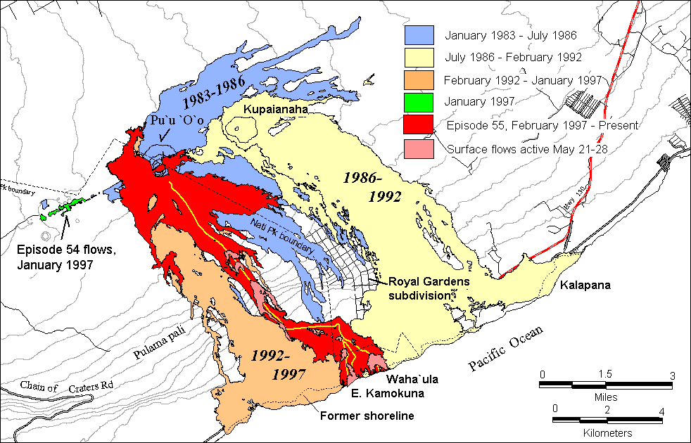
Pause on May 19-20 Leads to Lava Breakouts
A temporary pause in the supply of magma to Pu`u `O`o on May 19-20 permitted lava within the tube system to drain completely so that lava ceased flowing into the ocean at the Waha`ula and Kamokuna entry points. After lava began re-entering the tube system during the evening of May 20, several breakouts occurred along the length of the tube. The most voluminous breakouts began early in the morning of May 21 on the steep slope of the pali between 2,000 and 1,100 feet.
During a pause, the roof and walls of the drained tubes are prone to collapse. When lava reoccupies the tube system, blockages or irregularities in the tube cause the lava to back up and escape through skylights or other weak points. A prolonged period of surface flow activity inevitably results in lateral expansion of the lava-flow field, because the middle of the field is usually higher than the sides and new surface flows are diverted to the edges. During this most recent pause, however, the tube system quickly accommodated nearly all of the lava. The Kamokuna entry point resumed abruptly at about 1240 on May 21. Sixteen similar pauses have occurred since episode 55 began in March 1997.


Lava Entry Points Remain Hazardous
At the coast, the tube system continues to discharge lava into the ocean at two sites, Waha`ula and Kamokuna. Most of the lava enters the ocean at the Kamokuna entry point, where new land collapses into the ocean without warning, and various types of littoral explosions occur frequently. Following a collapse of the Kamokuna bench sometime between May 1 and 4, a new bench about 90 m wide was built by June 2. Numerous breakouts have been occurring along the entire bench area, and prominent cracks have formed immediately behind a new littoral cone that is forming on the seaward edge of the new bench. This bench is susceptible to collapse, which is likely to trigger vigorous explosions and scalding waves that can endanger people who venture too close to the entry point.


As the lava enters the sea it builds new land along the ocean edge. This land proves unstable, owing to the steep submarine slope along the south coast of the Big Island. The lava builds a low shelf known as a bench, but periodically the bench and its underpinnings slide seaward, a process called bench collapse. These collapses are life endangering; the land itself is destroyed and numerous explosions ensue as the hot lava reacts violently with the ocean water. For more information about this activity and the associated hazards, see:
- Collapse of new land into the sea
- Explosions at lava entry points
- Waves send scalding water onto new land
Eruption-viewing opportunities change constantly, so those readers planning a visit to the volcano should contact Hawai`i Volcanoes National Park for the most current eruption information (ph. 808-985-6000). Additional photographs and descriptions of east rift eruptive activity may be found on the University of Hawai`i's web site.
Get Our News
These items are in the RSS feed format (Really Simple Syndication) based on categories such as topics, locations, and more. You can install and RSS reader browser extension, software, or use a third-party service to receive immediate news updates depending on the feed that you have added. If you click the feed links below, they may look strange because they are simply XML code. An RSS reader can easily read this code and push out a notification to you when something new is posted to our site.