U.S. flag

An official website of the United States government

September 16, 2024

Kīlauea volcano erupted briefly last night just west of Nāpau Crater on the middle East Rift Zone. This eruption, which is now over, likely occurred between approximately 9:00 and 10:00 p.m. HST on Sunday 15, 2024, in a remote and closed area of Hawaiʻi Volcanoes National Park. 

Kīlauea volcano erupted briefly last night, September 15, 2024, on the middle East Rift Zone in Hawaiʻi Volcanoes National Park. USGS Hawaiian Volcano Observatory geologists conducted an aerial overflight this morning, to document the eruption and assess hazards. The Volcano Alert Level for ground-based hazards remains at WATCH and the Aviation Color Code remains at ORANGE at this time. Rates of seismicity and ground deformation beneath the summit, lower East Rift Zone, and Southwest Rift Zone remain low. Current activity is restricted to Kīlaueaʻs upper-to-middle East Rift Zone. 

A brief, small eruption occurred on the East Rift Zone of Kīlauea late on September 15. The eruption produced two small pads of lava just west of Nāpau crater, which is west (uprift) of the former Pu‘u‘ō‘ō eruption site. USGS video by M. Patrick.
This video, taken during a Hawaiian Volcano Observatory morning overflight of Kīlaueaʻs middle East Rift Zone on September 16, 2024, shows new lava flows erupted over about an hour during the evening on September 15, 2024.  Although the eruption was over by the time of the monitoring overflight, volcanic gas was continuing to be emitted by the new fissure vents in this remote area of Hawaiʻi Volcanoes National Park. Nāpau Crater is visible in the background of this photo. USGS video by M. Patrick. 
During a USGS Hawaiian Volcano Observatory overflight at approximately 10:30 a.m. HST on September 16, geologists observed freshly erupted lava west of Nāpau Crater on the remote middle East Rift Zone of Kīlauea, within Hawaiʻi Volcanoes National Park, surrounded by dead trees and vegetation. The eruption likely occurred between approximately 9–10 p.m. HST on September 15.  USGS video by M. Patrick. 
Color photograph of recent eruption site emitting volcanic gas and steam

Kīlauea volcano erupted briefly last night just west of Nāpau Crater on the middle East Rift Zone. This eruption, which is now over, likely occurred between approximately 9:00 and 10:00 p.m. HST on Sunday 15, 2024, in a remote and closed area of Hawaiʻi Volcanoes National Park. Chain of Craters Road, which is closed, is located downslope and downwind of the new fissures.  Continued degassing from the fissure system may pose a hazard to humans downwind of the eruption site.  The eruption does not currently pose an immediate threat to human life or infrastructure. 

The eruption took place near the National Park Nāpau campsite (east of Kānenuiohamo and Makaopuhi Crater and west of Nāpau Crater).  Small lava pads erupted from two fissure segments in a couple hundred meters (hundred yards).  The lava extended 50 or so meters (yards) from the fissure vents, with the uprift fissure segment being larger than the downrift fissure segment.  The eruption does not appear to have impacted Napau campground, but may have partly covered the pulu (Hawaiian tree fern) station nearby.  Vegetation in the eruption area was burned and sulfur dioxide continues to de-gas from the vents.  Residents of nearby subdivisions reported smelling volcanic gas and other smells related to this event during the evening of September 15. 

A photo taken from a helicopter shows a steaming fresh lava flow that has cut a slash through a green, forested landscape.
During a USGS Hawaiian Volcano Observatory overflight at approximately 10:30 a.m. HST on September 16, geologists observed freshly erupted lava west of Nāpau Crater on the remote middle East Rift Zone of Kīlauea, within Hawaiʻi Volcanoes National Park. This eruption likely occurred between approximately 9–10 p.m. HST on September 15.  

HVO is continuing to closely monitor the middle East Rift Zone and in contact with Hawai‘i Volcanoes National Park and the Hawai‘i County Civil Defense Agency. Temporary closures have been implemented as a result of this elevated activity; please see the Hawaiʻi Volcanoes National Park website for visitor information: https://www.nps.gov/havo/index.htm.   

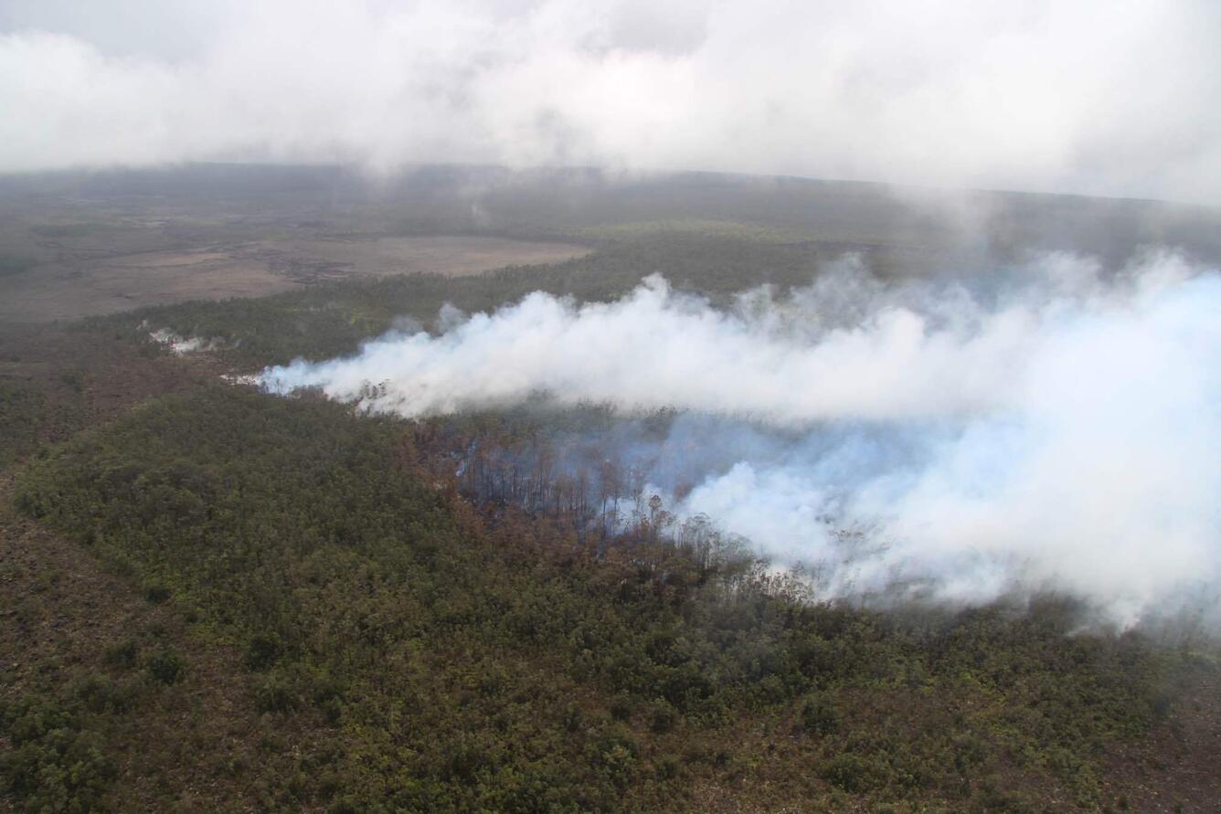
A photo taken from a helicopter shows plumes of white steam rising above a small fresh lava flow cutting through a jungle
During a USGS Hawaiian Volcano Observatory overflight at approximately 10:30 a.m. HST on September 16, geologists observed steam rising above freshly erupted lava west of Nāpau Crater on the remote middle East Rift Zone of Kīlauea, within Hawaiʻi Volcanoes National Park. This eruption likely occurred between approximately 9–10 p.m. HST on September 15.  USGS photo by M. Zoeller.
Color photograph of recently active volcanic vents emitting volcanic gas and steam
Another aerial view showing the new lava flows that had erupted over about an hour during the evening of September 15, 2024. Though no incandescence was observed during a USGS Hawaiian Volcano Observatory overflight the morning of September 16, volcanic gas and steam continues to issue from fissure vents on the middle East Rift Zone of Kīlauea, within Hawaiʻi Volcanoes National Park.  USGS photo by M. Zoeller. 

Numerous eruptions took place in Kīlauea's middle East Rift Zone during the 1960s–1970s. Most of these eruptions occurred between Hiʻiaka crater and Puʻuʻōʻō and lasted from less than one day to about two weeks, although there were long-lived eruptions at Maunaulu (1969–1971 and 1972–1974) and Puʻuʻōʻō (1983–2018).  A map of past eruptive activity in the upper-to-middle East Rift Zone of Kīlauea is available here: https://www.usgs.gov/maps/kilauea-middle-east-rift-zone-reference-map.  

Color map showing the ground temperature in an area where lava was recently erupted
This thermal map shows two small lava pads erupted late on September 15, just west of Nāpau Crater on the East Rift Zone of Kīlauea. This small eruption resulted from magma intruding from the summit into the East Rift Zone, and was associated with an increase in earthquake activity along the rift. The largest of the two lava pads was only about 200 m (yards) long. 
Color map of lava flows and fissure vents
This reference map depicts the fissure and lava flows from the Kīlauea middle East Rift Zone eruption of Sunday, September 15, 2024. The eruption occurred between approximately 9:00 and 10:00 p.m., in a remote and closed area of Hawaiʻi Volcanoes National Park. This map was constructed from data collected during a Hawaiian Volcano Observatory overflight the following morning, Monday, September 16. Geologists observed two lava pads covering 16,500 square meters (4 acres) that had erupted from a 480-meter (1600-foot) long fissure, which was eruptively inactive but still emitting volcanic gases at the time of the flight.

For more information about the meaning of volcano alert levels and aviation color codes, see https://www.usgs.gov/programs/VHP/volcanic-alert-levels-characterize-conditions-us-volcanoes 

Get Our News

These items are in the RSS feed format (Really Simple Syndication) based on categories such as topics, locations, and more. You can install and RSS reader browser extension, software, or use a third-party service to receive immediate news updates depending on the feed that you have added. If you click the feed links below, they may look strange because they are simply XML code. An RSS reader can easily read this code and push out a notification to you when something new is posted to our site.

Was this page helpful?