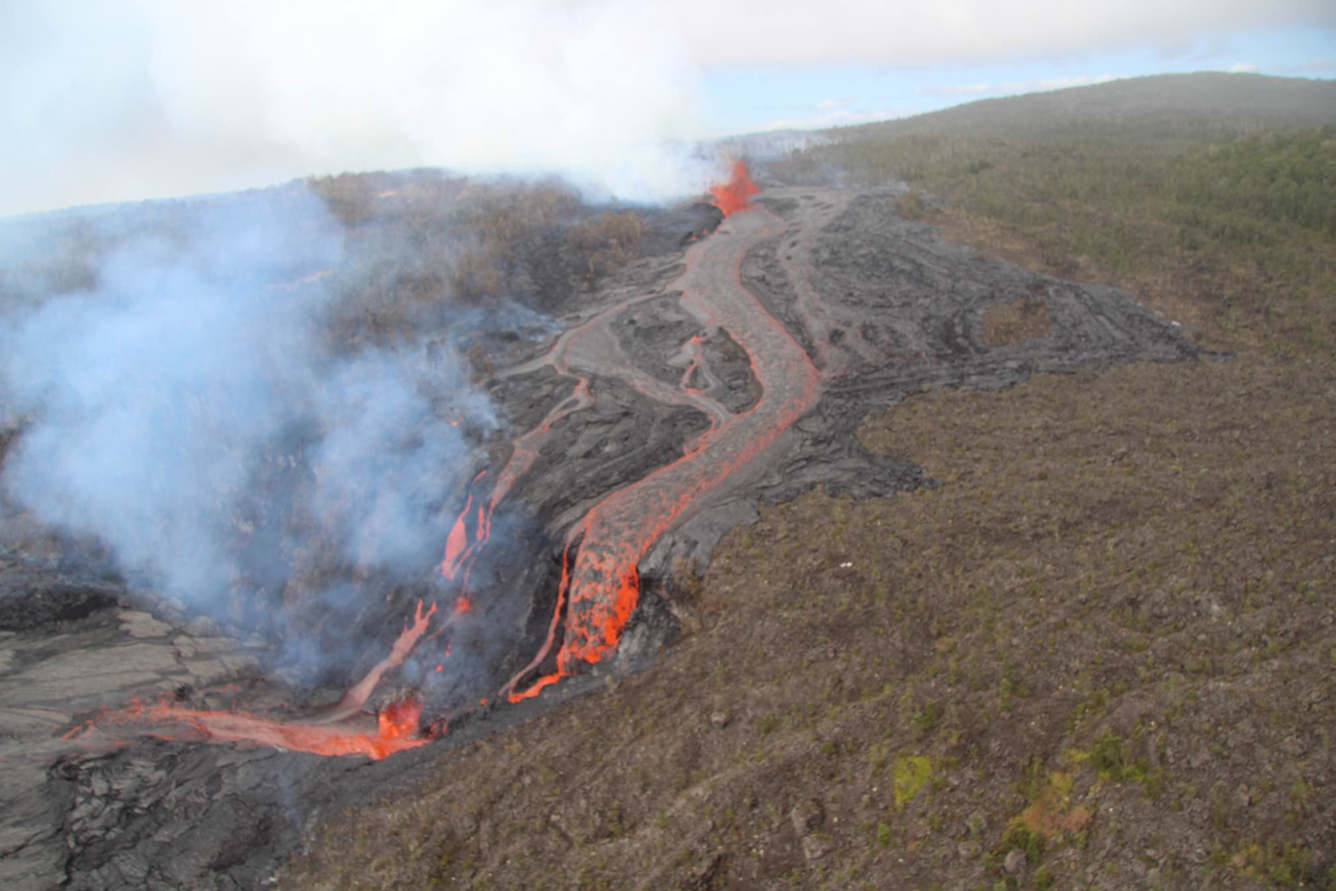
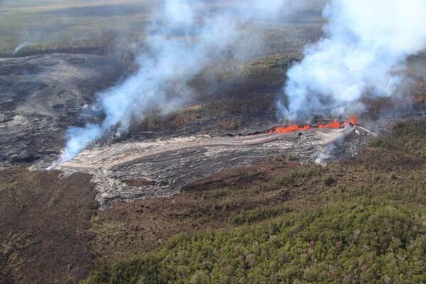
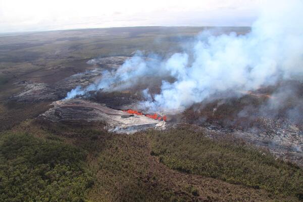
U.S. flag

An official website of the United States government

September 19, 2024

Kīlauea volcano continues to erupt in Hawai’i Volcanoes National Park near Nāpau Crater on the remote middle East Rift Zone. 

Last night, September 18, glow from the eruption was visible from Chain of Craters Road, which Hawaiʻi Volcanoes National Park reopened yesterday. 

Color photograph of glow from volcanic eruption
During the evening of September 18, the glow from the middle East Rift Zone eruption of Kīlauea was visible from the Keauhou Trail pull-off within Hawaiʻi Volcanoes National Park. USGS photo by K. Mulliken.


September 19 Overflight

On September 19, USGS Hawaiian Volcano Observatory geologists were able to capture this video of the fissure vent eruption west of Nāpau Crater on the middle East Rift Zone of Kīlauea. They observed a 150-m-long (nearly 500 feet) fissure west of the crater erupting lava in a curtain of lava 10-20 meters (33-66 feet) high. USGS video by M. Zoeller.
Video of USGS Hawaiian Volcano Observatory eruption monitoring overflight on September 19, 2024. Kīlauea middle East Rift Zone eruption near Nāpau Crater continues. USGS video by N. Deligne. 
Molten glowing lava cascades over the rim of a crater after flowing through the jungle from an erupting fissure
USGS Hawaiian Volcano Observatory geologists conducted a reconnaissance overflight of the eruption near Nāpau Crater on the middle East Rift Zone of Kīlauea. They observed lava cascading over the rim of the crater from a channel more than 50 meters (about 164 feet) wide. Lava is contained within Nāpau Crater and now covers about two thirds of the crater floor. USGS photo by M. Zoeller.
Color photograph of erupting vent
The 150-m-long (nearly 500 feet) fissure erupting west of Nāpau Crater within Hawaʻi Volcanoes National Park began erupting yesterday, September 18, around 3:15 p.m. It's part of an eruptive sequence that began in this area the night of September 15, 2024.  Overnight, this fissure fed a lava flow that cascaded into the crater via a channel more than 50 meters (about 164 feet) wide. USGS photo by M. Zoeller. 


Color photograph of eruption
During the USGS Hawaiian Volcano Observatory reconnaissance overflight the morning of September 19, geologists observed the fissure west of Nāpau Crater generating a lava flow that travels northeast before cascading into the crater on the remote middle East Rift Zone of Kīlauea. This aerial view is looking in a south direction, from north of the eruption site. Nāpau Crater is in the left part of the photo. USGS photo by M. Zoeller. 
Color photograph of vents erupting lava
USGS Hawaiian Volcano Observatory geologists conducted a reconnaissance overflight of the eruption near Nāpau Crater on the middle East Rift Zone of Kīlauea. They observed a 150-m-long (nearly 500 feet) fissure west of the crater erupting lava that is flowing in the crater via a channel more than 50 meters (about 164 feet) wide. Lava is contained within Nāpau Crater and now covers about two thirds of the crater floor. USGS photo by M. Zoeller. 
Helicopter view of a circular crater in the jungle, filled by black and brown lava. A lava waterfall glows on the far rim.
USGS Hawaiian Volcano Observatory geologists conducted a reconnaissance overflight of the eruption near Nāpau Crater on the middle East Rift Zone of Kīlauea. New lava from fissure eruptions over the past several days now covers about two thirds of the crater floor. USGS photo by M. Zoeller.
A curtain of molten lava erupting from a line of fissures sits behind a field of glossy black new lava flows
USGS Hawaiian Volcano Observatory geologists conducted a reconnaissance overflight of the eruption near Nāpau Crater on the middle East Rift Zone of Kīlauea. They observed a 150-m-long (nearly 500 feet) fissure west of the crater erupting lava in a curtain of lava 10-20 meters (33-66 feet) high. USGS photo by M. Zoeller.
Helicopter photo of lava erupting from a cluster of fissures. Lava flows in a river away from the viewer over a crater rim.
USGS Hawaiian Volcano Observatory geologists conducted a reconnaissance overflight of the eruption near Nāpau Crater on the middle East Rift Zone of Kīlauea. They observed a 150-m-long (nearly 500 feet) fissure west of the crater erupting lava that is flowing in the crater via a channel more than 50 meters (about 164 feet) wide. Lava is contained within Nāpau Crater and now covers about two thirds of the crater floor. Flows erupted on September 15-16 are visible steaming in the foreground. USGS photo by M. Zoeller.

September 19, 2024 — Thermal map of eruption on Kīlauea East Rift Zone

Color map of ground temperature in area with ongoing eruption
A helicopter overflight on September 19, 2024, allowed for aerial visual and thermal imagery to be collected at the middle East Rift Zone eruption site on Kīlauea. The eruptive activity continues with a fissure vent active west of Nāpau Crater generating lava flows northeast into the crater. The scale of the thermal map ranges from blue to red, with blue colors indicative of cooler temperatures and red colors indicative of warmer temperatures.
Color map of lava flows and fissure vents
This reference map depicts fissures and lava flows from the Kīlauea middle East Rift Zone eruption on Thursday, September 19, 2024. Map data are current as of the Hawaiian Volcano Observatory helicopter overflight that occurred between 9:00 and 10:00 a.m. Areas in bright red represent new lava flows since the area was last mapped late on September 18, with these new flows now covering most of the floor of Nāpau Crater. In total, the fissure system has stretched over 1.8 kilometers (1.1 miles) of the East Rift Zone, with the lava flows now covering 63 hectares (156 acres).

Get Our News

These items are in the RSS feed format (Really Simple Syndication) based on categories such as topics, locations, and more. You can install and RSS reader browser extension, software, or use a third-party service to receive immediate news updates depending on the feed that you have added. If you click the feed links below, they may look strange because they are simply XML code. An RSS reader can easily read this code and push out a notification to you when something new is posted to our site.

Was this page helpful?