Collecting fish using a seine at Lincoln Creek near 47th Street in Milwaukee, Wisconsin in summer. LINCOLN CREEK AT 47TH STREET AT MILWAUKEE, WI - USGS Water Data for the Nation
Amanda H Bell
(She/Her)Over the past 21 years working for the Survey, I have had the privilege to study aquatic ecosystems in the upper Midwest and across the country. The resilience of our natural systems to overcome chemical, physical and biological changes brought on by increasing human populations amazes me and is the main reason I love to study the aquatic ecosystem.
I have lived, studied, and worked in the Upper Midwest most of my life and I have been studying in the Lake Michigan Basin in some capacity my entire career. I have also conducted field work throughout the U.S. broadening my experience and expertise. The Upper Midwest Water Science Center (formerly Wisconsin Water Science Center) has been my home for over 21 years and I want the Center to continue to be a beacon of scientific ingenuity and advancement. Since the Minnesota, Wisconsin and Michigan offices merged in 2017, many unique challenges and opportunities have risen on combining the localized nuances of management, supervision and implementation of policies.
Over the last 3 years I have had the opportunity to serve as the Team Leader for the Integrated Ecosystems Studies and Groundwater Characterization Teams. This experience solidified my desire to be a leader in our organization. Since beginning my role as IES Team Leader and Supervisor, the team members have developed and lead projects from dozens of cooperators across multiple states and international boundaries, totaling over $2.6 million dollars per year.
Beginning in summer of 2021, I began duties pursuant to Center Operations and have been selected as the Center’s Operations Officer. These duties include leading the teams for moving offices, helping the safety teams find direction, perform clean-ups and find their stride, leading the IT team until the new supervisor joined the center, and leading the charge to overhaul the fleet management. As a member of the Executive Leadership Team, I helped resolve concerns related to facilities, operations, data management among other topics. This role was a huge undertaking while continuing to perform my duties as a Team Leader, however, I excelled and move the Center forward during this transition time of not having a permanent Operations Officer.
I enjoy working in a team environment where the personal dynamics foster a professional respect and conflicts are resolved through open communication and a judicial approach. I have a strong work ethic that is reflected in my productivity and dedication to detail. I am a natural-born leader that enjoys helping others develop projects that line with their passions and interests. Thriving on organizing logistics, I can find the people with the right experience and skill to fill the roles they best fit into. I am learning different techniques for personnel conflicts and how to accommodate personalities that differ from my own. I pride myself on clear, honest, and efficient communication in both praise and critique. I value open communication and above all else integrity in my work and personal life.
Professional Experience
April 2022 - Present - Center Operations Officer, GS-14, USGS Upper Midwest Water Science Center
March 2020 – April 2022 - Supervisory Hydrologist, GS-13, USGS Upper Midwest Water Science Center
May 2001 – February 2020 - Hydrologist, GS-12, USGS Upper Midwest Water Science Center
June 2021 – January 2022 - Acting Deputy Director For Operations, GS-13, USGS Upper Midwest Water Science Center
Education and Certifications
M.S. Natural Resources - 2005, University of Wisconsin-Stevens Point
B.S. Watershed Management - 2002, University of Wisconsin-Stevens Point
Affiliations and Memberships*
Professional Organizations
Wisconsin Section of the American Water Resources Association
o Member 2005-present
o Past President 2019
o President 2018
o President Elect 2017
o Vice President 2016
o Director at Large 2013-2015Wisconsin Conservation Hall of Fame
o AWRA representative 2018-present
o Executive committee 2019-2021
o Vice President Nov. 2020-2021
Science and Products
Summary of fish communities along Underwood Creek, Milwaukee, Wisconsin, 2004–2019
Development and application of a risk assessment tool for aquatic invasive species in the international Rainy-Lake of the Woods Basin, United States and Canada
The Rainy-Lake of the Woods Basin covers 70,000 square kilometers in mid-central North America and is contained within the Provinces of Ontario and Manitoba in Canada and the State of Minnesota in the United States. This basin contains natural wilderness areas, national parks, and thousands of lakes that bring outdoor enthusiasts from around the world for hunting, fishing, backpacking, boating, an
Summary of fish communities along Underwood Creek, Milwaukee, Wisconsin, 2004–2019
Physical and chemical stressors on algal, invertebrate, and fish communities in 14 Milwaukee area streams, 2004–2013
Ecological status of aquatic communities in selected streams in the Milwaukee Metropolitan Sewerage District planning area of Wisconsin, 2004–13
Design and methods of the California stream quality assessment (CSQA), 2017
Benthos and plankton of western Lake Michigan Areas of Concern in comparison to non-Areas of Concern for selected rivers and harbors, 2012 and 2014
Design and methods of the U.S. Geological Survey Northeast Stream Quality Assessment (NESQA), 2016
An evaluation of the zooplankton community at the Sheboygan River Area of Concern and non-Area of Concern comparison sites in western Lake Michigan rivers and harbors in 2016
Design and methods of the Pacific Northwest Stream Quality Assessment (PNSQA), 2015
Comparison of benthos and plankton for selected areas of concern and non-areas of concern in western Lake Michigan Rivers and Harbors in 2012
Benthos and plankton community data for selected rivers and harbors along the western Lake Michigan shoreline, 2014
Design and methods of the Southeast Stream Quality Assessment (SESQA), 2014
Aquatic community and environmental data for 14 rivers and streams in the Milwaukee Metropolitan Sewerage District Planning Area, 2004-13
Geospatial database of the study boundary, sampled sites, watersheds, and riparian zones for U.S. Geological Survey Southeast Stream Quality Assessment

Collecting fish using a seine at Lincoln Creek near 47th Street in Milwaukee, Wisconsin in summer. LINCOLN CREEK AT 47TH STREET AT MILWAUKEE, WI - USGS Water Data for the Nation

Fish sampling using a seine. USGS scientists use a seine to sample fish communities in the Little Menomonee River at Milwaukee, Wisconsin. LITTLE MENOMONEE RIVER AT MILWAUKEE, WI - USGS Water Data for the Nation.
Fish sampling using a seine. USGS scientists use a seine to sample fish communities in the Little Menomonee River at Milwaukee, Wisconsin. LITTLE MENOMONEE RIVER AT MILWAUKEE, WI - USGS Water Data for the Nation.

Fish sampling using a backpack shocker. USGS scientists use a backpack-mounted electrofishing device to sample fish communities in the Menomonee River at Wauwatosa, WI (MENOMONEE RIVER AT WAUWATOSA, WI - USGS Water Data for the Nation), near 70th Street.
Fish sampling using a backpack shocker. USGS scientists use a backpack-mounted electrofishing device to sample fish communities in the Menomonee River at Wauwatosa, WI (MENOMONEE RIVER AT WAUWATOSA, WI - USGS Water Data for the Nation), near 70th Street.
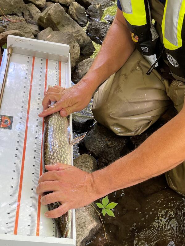
Fish are weighed and measured for length.
Fish are weighed and measured for length.
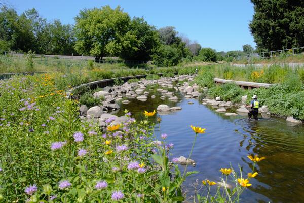
Habitat sampling at a restored reach at Underwood Creek at Wauwatosa, Wisconsin. https://waterdata.usgs.gov/monitoring-location/04087088/
Habitat sampling at a restored reach at Underwood Creek at Wauwatosa, Wisconsin. https://waterdata.usgs.gov/monitoring-location/04087088/
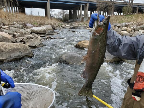
USGS scientist holding a milting rainbow trout caught as part of an assessment of fish passage in Underwood Creek at Wauwatosa, Wisconsin, just downstream of I-41/US 45. https://waterdata.usgs.gov/monitoring-location/04087088/
USGS scientist holding a milting rainbow trout caught as part of an assessment of fish passage in Underwood Creek at Wauwatosa, Wisconsin, just downstream of I-41/US 45. https://waterdata.usgs.gov/monitoring-location/04087088/
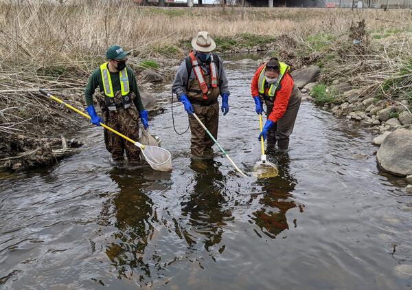
USGS scientists electrofishing with a backpack shocker at Underwood Creek at Wauwatosa, Wisconsin. https://waterdata.usgs.gov/monitoring-location/04087088/.
USGS scientists electrofishing with a backpack shocker at Underwood Creek at Wauwatosa, Wisconsin. https://waterdata.usgs.gov/monitoring-location/04087088/.
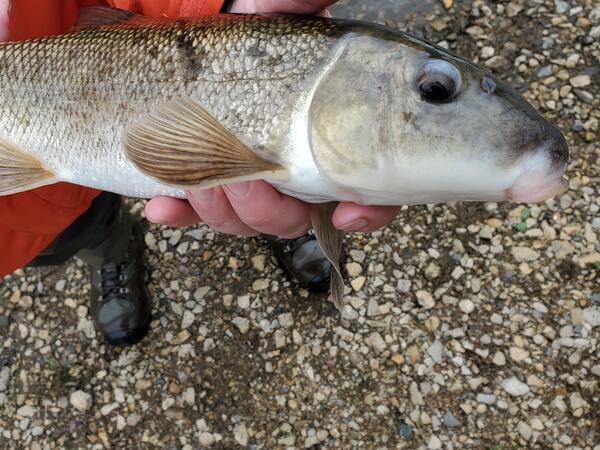
USGS scientist holding a white sucker fish caught in Underwood Creek at Wauwatosa, Wisconsin. https://waterdata.usgs.gov/monitoring-location/04087088/
USGS scientist holding a white sucker fish caught in Underwood Creek at Wauwatosa, Wisconsin. https://waterdata.usgs.gov/monitoring-location/04087088/
Fish are identified and counted in the field, and game fish are measured for total length and weighed, before being released live back to the stream site.
Fish are identified and counted in the field, and game fish are measured for total length and weighed, before being released live back to the stream site.
Science and Products
Summary of fish communities along Underwood Creek, Milwaukee, Wisconsin, 2004–2019
Development and application of a risk assessment tool for aquatic invasive species in the international Rainy-Lake of the Woods Basin, United States and Canada
The Rainy-Lake of the Woods Basin covers 70,000 square kilometers in mid-central North America and is contained within the Provinces of Ontario and Manitoba in Canada and the State of Minnesota in the United States. This basin contains natural wilderness areas, national parks, and thousands of lakes that bring outdoor enthusiasts from around the world for hunting, fishing, backpacking, boating, an
Summary of fish communities along Underwood Creek, Milwaukee, Wisconsin, 2004–2019
Physical and chemical stressors on algal, invertebrate, and fish communities in 14 Milwaukee area streams, 2004–2013
Ecological status of aquatic communities in selected streams in the Milwaukee Metropolitan Sewerage District planning area of Wisconsin, 2004–13
Design and methods of the California stream quality assessment (CSQA), 2017
Benthos and plankton of western Lake Michigan Areas of Concern in comparison to non-Areas of Concern for selected rivers and harbors, 2012 and 2014
Design and methods of the U.S. Geological Survey Northeast Stream Quality Assessment (NESQA), 2016
An evaluation of the zooplankton community at the Sheboygan River Area of Concern and non-Area of Concern comparison sites in western Lake Michigan rivers and harbors in 2016
Design and methods of the Pacific Northwest Stream Quality Assessment (PNSQA), 2015
Comparison of benthos and plankton for selected areas of concern and non-areas of concern in western Lake Michigan Rivers and Harbors in 2012
Benthos and plankton community data for selected rivers and harbors along the western Lake Michigan shoreline, 2014
Design and methods of the Southeast Stream Quality Assessment (SESQA), 2014
Aquatic community and environmental data for 14 rivers and streams in the Milwaukee Metropolitan Sewerage District Planning Area, 2004-13
Geospatial database of the study boundary, sampled sites, watersheds, and riparian zones for U.S. Geological Survey Southeast Stream Quality Assessment

Collecting fish using a seine at Lincoln Creek near 47th Street in Milwaukee, Wisconsin in summer. LINCOLN CREEK AT 47TH STREET AT MILWAUKEE, WI - USGS Water Data for the Nation
Collecting fish using a seine at Lincoln Creek near 47th Street in Milwaukee, Wisconsin in summer. LINCOLN CREEK AT 47TH STREET AT MILWAUKEE, WI - USGS Water Data for the Nation

Fish sampling using a seine. USGS scientists use a seine to sample fish communities in the Little Menomonee River at Milwaukee, Wisconsin. LITTLE MENOMONEE RIVER AT MILWAUKEE, WI - USGS Water Data for the Nation.
Fish sampling using a seine. USGS scientists use a seine to sample fish communities in the Little Menomonee River at Milwaukee, Wisconsin. LITTLE MENOMONEE RIVER AT MILWAUKEE, WI - USGS Water Data for the Nation.

Fish sampling using a backpack shocker. USGS scientists use a backpack-mounted electrofishing device to sample fish communities in the Menomonee River at Wauwatosa, WI (MENOMONEE RIVER AT WAUWATOSA, WI - USGS Water Data for the Nation), near 70th Street.
Fish sampling using a backpack shocker. USGS scientists use a backpack-mounted electrofishing device to sample fish communities in the Menomonee River at Wauwatosa, WI (MENOMONEE RIVER AT WAUWATOSA, WI - USGS Water Data for the Nation), near 70th Street.

Fish are weighed and measured for length.
Fish are weighed and measured for length.

Habitat sampling at a restored reach at Underwood Creek at Wauwatosa, Wisconsin. https://waterdata.usgs.gov/monitoring-location/04087088/
Habitat sampling at a restored reach at Underwood Creek at Wauwatosa, Wisconsin. https://waterdata.usgs.gov/monitoring-location/04087088/

USGS scientist holding a milting rainbow trout caught as part of an assessment of fish passage in Underwood Creek at Wauwatosa, Wisconsin, just downstream of I-41/US 45. https://waterdata.usgs.gov/monitoring-location/04087088/
USGS scientist holding a milting rainbow trout caught as part of an assessment of fish passage in Underwood Creek at Wauwatosa, Wisconsin, just downstream of I-41/US 45. https://waterdata.usgs.gov/monitoring-location/04087088/

USGS scientists electrofishing with a backpack shocker at Underwood Creek at Wauwatosa, Wisconsin. https://waterdata.usgs.gov/monitoring-location/04087088/.
USGS scientists electrofishing with a backpack shocker at Underwood Creek at Wauwatosa, Wisconsin. https://waterdata.usgs.gov/monitoring-location/04087088/.

USGS scientist holding a white sucker fish caught in Underwood Creek at Wauwatosa, Wisconsin. https://waterdata.usgs.gov/monitoring-location/04087088/
USGS scientist holding a white sucker fish caught in Underwood Creek at Wauwatosa, Wisconsin. https://waterdata.usgs.gov/monitoring-location/04087088/
Fish are identified and counted in the field, and game fish are measured for total length and weighed, before being released live back to the stream site.
Fish are identified and counted in the field, and game fish are measured for total length and weighed, before being released live back to the stream site.
*Disclaimer: Listing outside positions with professional scientific organizations on this Staff Profile are for informational purposes only and do not constitute an endorsement of those professional scientific organizations or their activities by the USGS, Department of the Interior, or U.S. Government


