An official website of the United States government
Here's how you know
Official websites use .gov
A .gov website belongs to an official government organization in the United States.
Secure .gov websites use HTTPS
A lock () or https:// means you’ve safely connected to the .gov website. Share sensitive information only on official, secure websites.
An aerial view of Kīlauea Volcano's summit taken on August 1. A section of Hawai‘i Volcanoes National Park's Crater Rim Drive and the road leading to the Kīlauea Overlook parking area are visible at lower right. HVO, Jaggar Museum, and the museum parking area are visible at far middle right. A down-dropped section of the caldera floor can be seen to the left of Halema‘uma‘u, a crater that continues to grow. On the caldera rim (upper right) light-colored ash deposits from explosions in May are stirred up by brisk winds, creating a dust cloud that's blown downwind.
Then and now. It has proven difficult to exactly match past and present views of Kīlauea'S summit to show the dramatic changes in the volcanic landscape, but here's our latest attempt. At left is a photo taken on November 28, 2008, with a distinct gas plume rising from the vent that had opened within Halema‘uma‘u about eight months earlier. At right is a photo taken on August 1, 2018, to approximate the 2008 view for comparison.
During this morning's overflight, HVO geologists used a telephoto lens to capture this image of the fissure 8 cone. Activity within the vent was low, with small bubble bursts in the eastern part of the vent and low lava fountains on the western side. The fountains occasionally threw spatter onto the west rim of the cone (right).
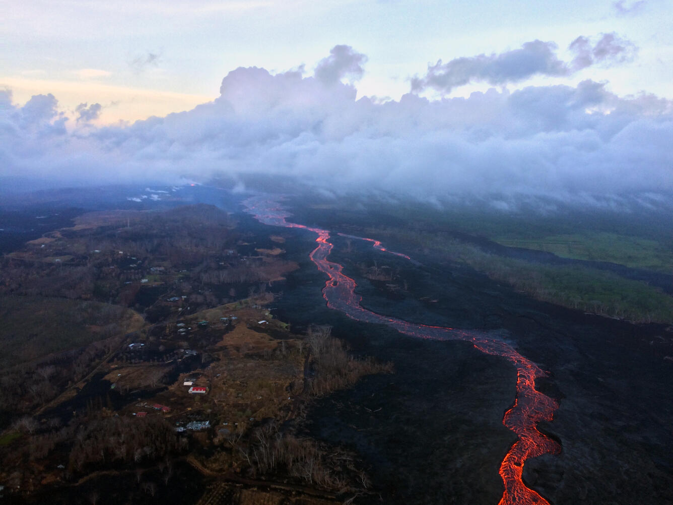
An early morning aerial view (looking west) of the fissure 8 lava channel. Downstream of the vent, the channel splits to form a "braided" section in the lava channel, and, this morning, the north (right) arm of the braided section appeared to be partially abandoned. Lava was still visible in part of the northern braid, but the lower section was only weakly incandescent. During today's overflight, lava within the channel generally appeared to be at a lower level than in previous days.
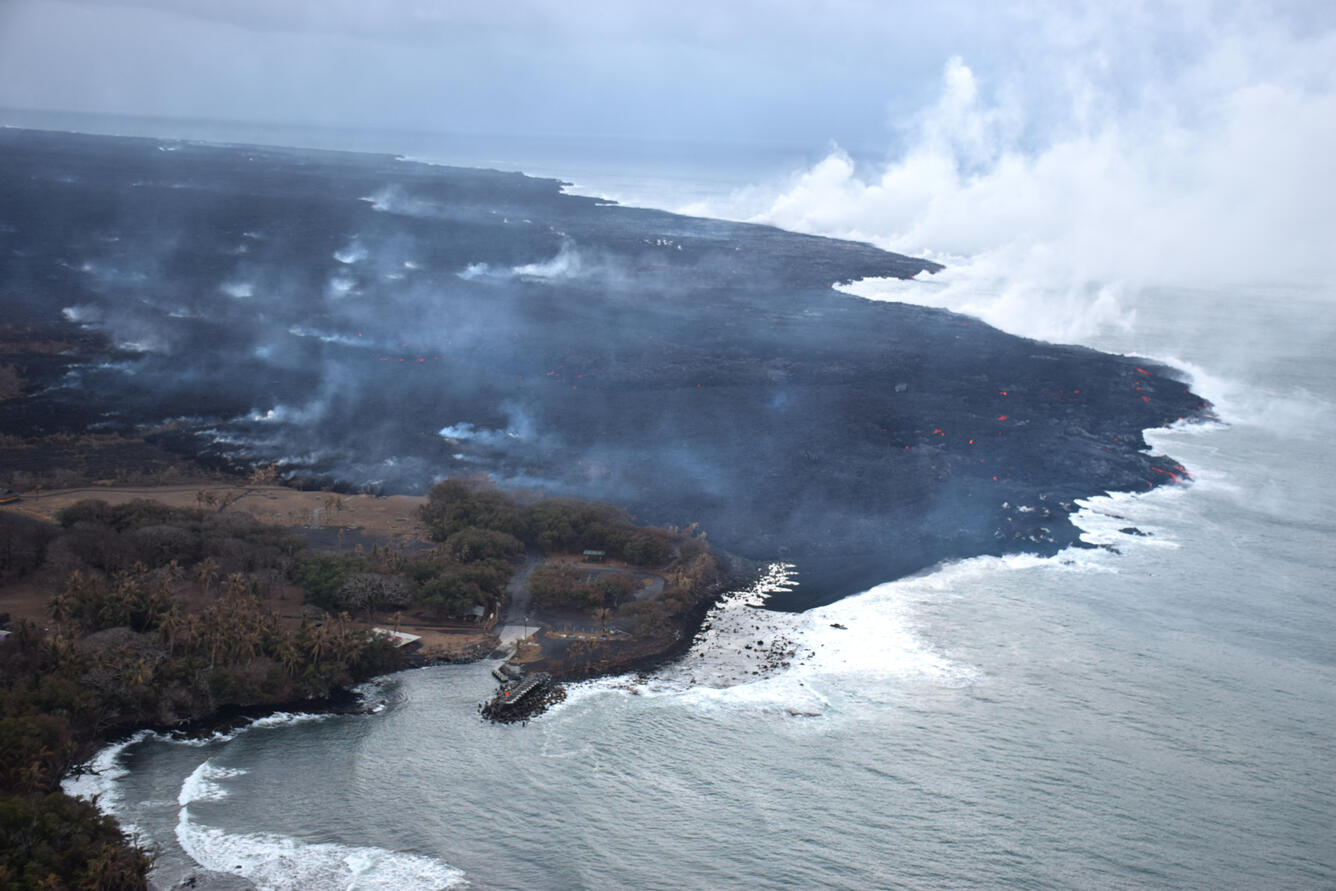
During this morning's overflight, the ocean entry laze plume was being blown offshore, allowing this fairly clear view (looking west) of the Pohoiki boat ramp at Isaac Hale Beach Park. Incandescent (glowing red) spots of lava can be seen within the flow field beyond the boat ramp. HVO geologists also observed a few oozes of lava on or near the western flow margin, but all appeared weak as of 6:00 a.m. HST.
On July 13, we posted an image of a tiny "island" forming just offshore of the Kapoho ocean entry. Today, that feature—likely a submarine tumulus of lava that built up underwater and emerged above sea level—is no longer an "island." It now looks more like a peninsula, attached to the coast by a black sand tombolo, a sandy isthmus, creating a feature known as a "tied island." Whether or not it will withstand wave erosion over time remains to be seen.
Rockfalls along Kīlauea's caldera walls are common during summit collapse events. This image, taken just after today's 11:55 a.m. HST collapse, shows dust rising from rockfalls along Uēkahuna Bluff.
Get Our News
These items are in the RSS feed format (Really Simple Syndication) based on categories such as topics, locations, and more. You can install and RSS reader browser extension, software, or use a third-party service to receive immediate news updates depending on the feed that you have added. If you click the feed links below, they may look strange because they are simply XML code. An RSS reader can easily read this code and push out a notification to you when something new is posted to our site.