An official website of the United States government
Here's how you know
Official websites use .gov
A .gov website belongs to an official government organization in the United States.
Secure .gov websites use HTTPS
A lock () or https:// means you’ve safely connected to the .gov website. Share sensitive information only on official, secure websites.
Kīlauea's summit eruption continues on the Island of Hawai‘i. Halema‘uma‘u west vent remains active; the lava lake level has not changed significantly. Summit gas emissions and seismic activity remain elevated. HVO field crews—equipped with specialized safety gear and PPE—monitor the current eruption from the closed area of
Overnight, the eruption in Halema‘uma‘u at Kīlauea's summit continued. At about 3:45 a.m. HST this morning (Dec. 30), HVO field crews measured the lava lake as 181 m (593 ft) deep with a narrow black ledge around it. This photo, taken at around 2 a.m. HST December 30, shows that lava continues to flow from the west vents into the lava lake. Reduced, but still elevated, SO2 emissions were measured at Kīlauea's summit on Monday (Dec. 28), with rates of about 3,300 tonnes/day. USGS photo by H. Dietterich.
HVO field crews observed activity within Halema‘uma‘u, at Kīlauea Volcano's summit, overnight from within a closed area of Hawai‘i Volcanoes National Park. The area remains closed to the public for safety reasons and HVO field crews are equipped with a range of specialized safety gear and personal protective equipment. In the early hours of December 30, the western vent in the wall of Halema‘uma‘u continued to erupt primarily effusively (flowing lava), but sporadic strombolian activity (minor explosions ejecting lava into the air) was also observed at the top of the west vent. USGS photo by H. Dietterich.
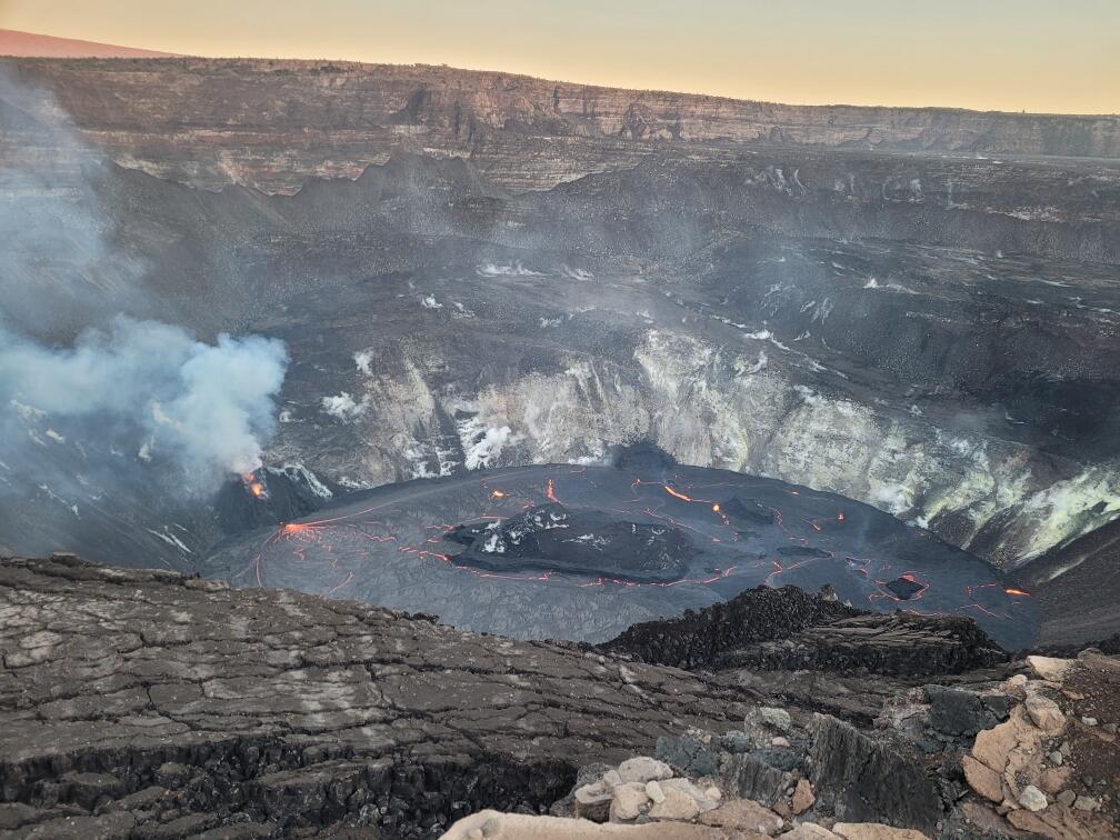
The lava lake within Halemaʻumaʻu crater has changed little in the past few days.The most recent thermal map (Dec. 28) provided the lake dimensions as 770 by 490 m (840 by 535 yds) for a total area of 29 ha (72 acres). Over the past day, the main island of cooler, solidified lava floating in the lava lake (the raised mass visible in the center of the photo) drifted slightly to the west (left in the photo) in the lake and rotated counter-clockwise, whereas the 10 or so much smaller islands to the east (raised masses to the right of the island in the photo) remained stationary. The main island measured about 250 m (820 ft) in length, 135 m (440 ft) in width, and about 3 ha (7 acres) in area based on the Dec. 28 thermal map. Measurements on Dec. 27 show that the island surface was about 6 m (20 ft) above the lake surface. USGS photo by N. Deligne.
During an HVO helicopter overflight of Kīlauea Volcano’s summit this morning (December 30), geologists collected photos and thermal imagery to document eruptive changes and to make maps of the lava lake within Halema‘uma‘u crater. This aerial photo, taken at approximately 10:00 a.m. HST, shows the lava lake that is slowly rising within Halema‘uma‘u crater. The west vent remains active and continues to emit a small plume. SO2 emission rates remain elevated. USGS photo taken by L. DeSmither.
Video from a helicopter overflight of Kīlauea summit eruption on December 30, 2020, around 10:00 a.m., shows the western vents (area of bluish-colored gas emissions on left) erupting through crusted-over channels into a lava lake within Halema'uma'u crater.As of December 30, at 3:45 a.m., the lava lake was 181 m (593 ft) deep. The lake volume was about 23 million cubic meters (30 million cubic yards or 5.2 billion gallons). The most recent measurement of the lake shows that it covers an area of 29 ha (72 acres). The large “raft” in the center of the lava lake is about 250 m (820 ft) in length, 135 m (440 ft) in width, and about 3 ha (7 acres) in area.Visual and thermal images collected during the overflight are used to map the ongoing activity and assess hazards during the eruption. Video by Matt Patrick (Public domain).
A telephoto view of the west vent taken during this morning’s overflight of Kīlauea Volcano’s summit, at about 10:00 a.m. HST. The west vent in Halema‘uma‘u crater remains active, with two vents visibly glowing on either side of the spatter cone. The crusted over channel feeds lava into the lake from the western-most vent (left). USGS photo by L. DeSmither.
Annotated eruption photograph taken at 5 p.m. HST on December 30, 2020, from the south rim of Halemaʻumaʻu, Kīlauea Volcano summit. USGS photo by K. Lynn.
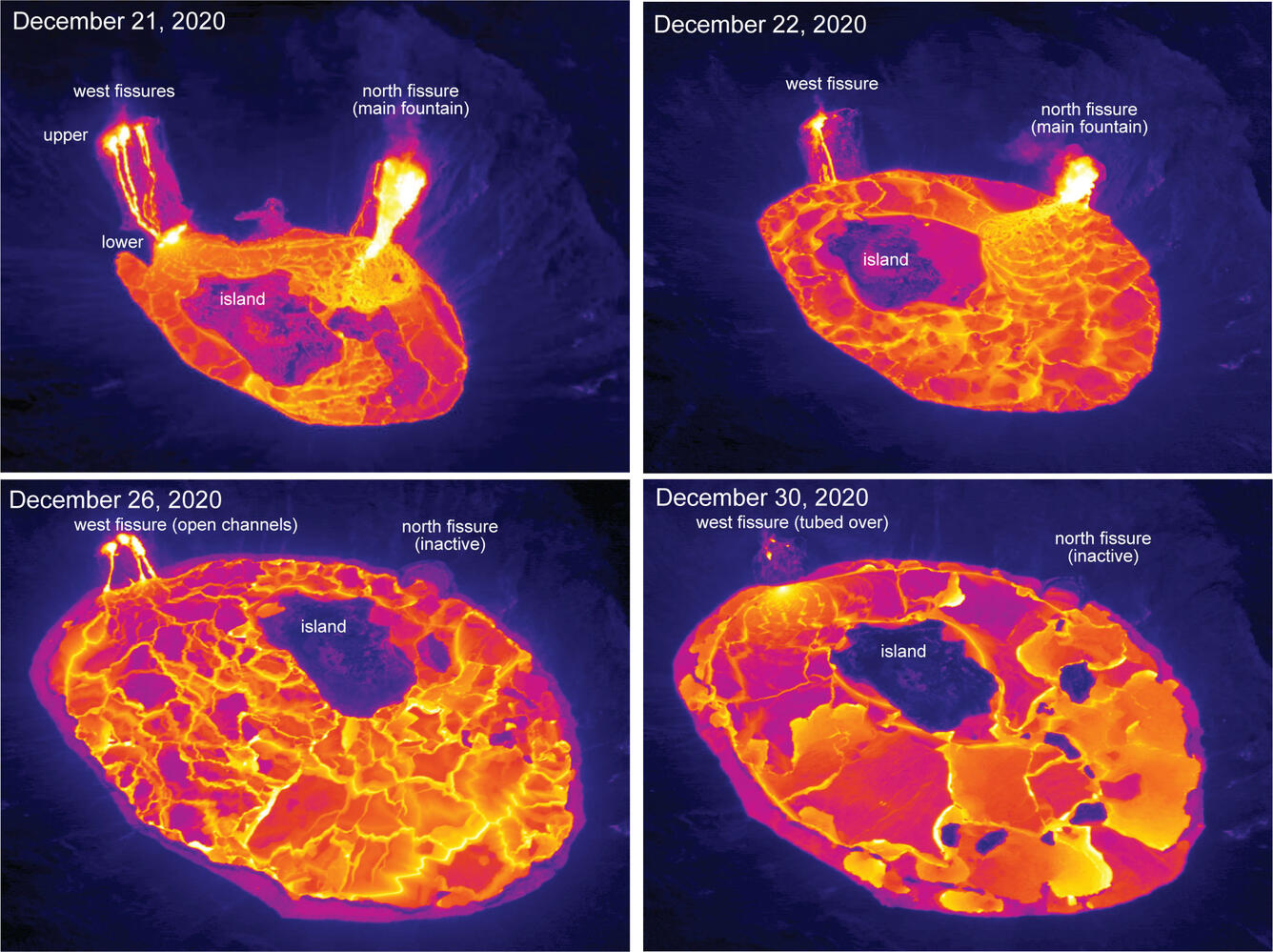
These aerial thermal images of Kīlauea Volcano’s summit compare the changes within Halema‘uma‘u crater over the course of this summit eruption. The first image (upper left) was taken on December 21, the morning after the eruption started, with the north and west fissure vents feeding the lava lake and the middle fissure inactive. The depth of the lava lake was approximately 88 m (289 ft). By the next morning, December 22, (upper right) the lava lake depth increased to about 134 m (440 ft) and had drowned the inactive middle fissure. In the December 26 image (lower left), the north fissure is inactive and only the west fissure vents are feeding lava into the lava lake, which was at a depth of about 176 m (577 ft) that morning. During today’s overflight (lower right), the lava lake was approximately 182 m (597 ft) deep, and lava flowing into the lake was crusted over. Note the change in position over time of the island within the lava lake. USGS thermal images taken by M. Patrick.
Get Our News
These items are in the RSS feed format (Really Simple Syndication) based on categories such as topics, locations, and more. You can install and RSS reader browser extension, software, or use a third-party service to receive immediate news updates depending on the feed that you have added. If you click the feed links below, they may look strange because they are simply XML code. An RSS reader can easily read this code and push out a notification to you when something new is posted to our site.