An official website of the United States government
Here's how you know
Official websites use .gov
A .gov website belongs to an official government organization in the United States.
Secure .gov websites use HTTPS
A lock () or https:// means you’ve safely connected to the .gov website. Share sensitive information only on official, secure websites.
Kīlauea's summit eruption continues on the Island of Hawai‘i; the west vent in Halema‘uma‘u erupts lava into the lava lake. Gas emissions and seismic activity at the summit remain elevated. HVO field crews—equipped specialized safety gear and PPE—monitor the current eruption from within the closed area of Hawai‘i Volcanoes Natio
HVO scientists collect detailed data to assess hazards and understand how the eruption is evolving at Kīlauea's summit, all of which are shared with the National Park Service and emergency managers. Access to this hazardous area is by permission from, and in coordination with, Hawai‘i Volcanoes National Park.
At Halema‘uma‘u, the west vents (visible in the foreground of this photo as two glowing holes on a cone-shaped feature) erupt occaisional spatter. Lava is also emerging in a small dome fountain above the lake crust in front of the west vents, probably from a submerged portion of the vent (visible in the background of this photo as a bright spot with lava crust boundaries emanating from it like a spider web). These processes can be observed in Kīlauea Volcano's summit F1 thermal webcam view of the lava lake. USGS photo by H. Dietterich.
Early this morning, the west vents in Halema‘uma‘u spattered from two places at the top of a small cone plastered on the northwest wall. This process can be seen in Kīlauea Volcano's summit F1 thermal webcam view of the lava lake. USGS photo by H. Dietterich.
The eruption in Halema‘uma‘u, at Kīlauea Volcano's summit, continues. Lava activity is confined to Halemaʻumaʻu with lava erupting from vents on the northwest side of the crater. Yesterday afternoon (Jan. 2), HVO field geologists observed that the lava lake was 190 m (623 ft) deep and perched about a meter (yard) above its edge. SO2 emission rates were still elevated. USGS photo by F. Trusdell.
HVO geologists shared this look through the laser rangefinder viewfinder, showing the west vents in Halema‘uma‘u and the dome fountain in the lava lake. The small dome fountain rises above the lake crust in front of the west vents and is probably from a submerged portion of the vent. USGS photo by K. Lynn.
The west vents in Halema‘uma‘u continue to erupt. The large island in Kīlauea's summit lava lake has drifted closer to the west vent area, where a dome fountain has become more vigorous in the past day. USGS photo by K. Lynn.
Over the past week, the lava lake in Halema‘uma‘u has developed a subtle levee around its perimeter that allows the lake to be slightly perched above its base, like a mesa. The levees grow from repeated small overflows, and the rafting and piling of pieces of surface crust that fuse together into a barrier that impounds the fluid lake. This is called a "perched" lava lake, and this geometry has been common for lava lakes at Kīlauea's summit and rift zones. For example, see this photo of a perched lava pond within Pu‘u ‘Ō‘ō crater in 2011. USGS photo by M. Patrick on Jan. 1, 2021.
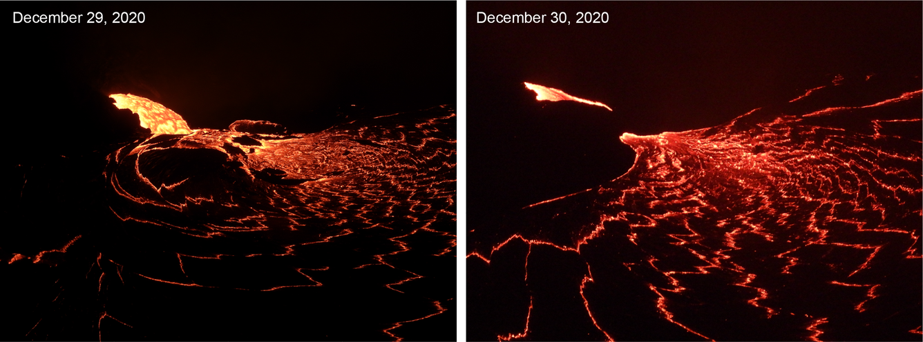
The west vent in Halema‘uma‘u crater continues to erupt at Kīlauea’s summit. These telephoto images from December 29 (left) and December 30 (right) compare the lava lake surface below the west vent. The west vent is supplying lava to the lake through a crusted over channel, which was starting to form by December 30. USGS photos by H. Dietterich.
The west vent in Halema‘uma‘u crater continues to erupt at Kīlauea’s summit. These telephoto images from January 1 (left) and January 2 (right) compare the lava lake surface below the west vent. The west vent is supplying lava to the lake through a crusted over channel, which enters just below the lake surface. As the lava enters the lake, it produces localized upwelling at the surface. By January 2 there appears to be an increase in eruptive vigor where a small dome-like fountain is breaking through the surface crust. USGS photos by M. Patrick.
Get Our News
These items are in the RSS feed format (Really Simple Syndication) based on categories such as topics, locations, and more. You can install and RSS reader browser extension, software, or use a third-party service to receive immediate news updates depending on the feed that you have added. If you click the feed links below, they may look strange because they are simply XML code. An RSS reader can easily read this code and push out a notification to you when something new is posted to our site.