An official website of the United States government
Here's how you know
Official websites use .gov
A .gov website belongs to an official government organization in the United States.
Secure .gov websites use HTTPS
A lock () or https:// means you’ve safely connected to the .gov website. Share sensitive information only on official, secure websites.
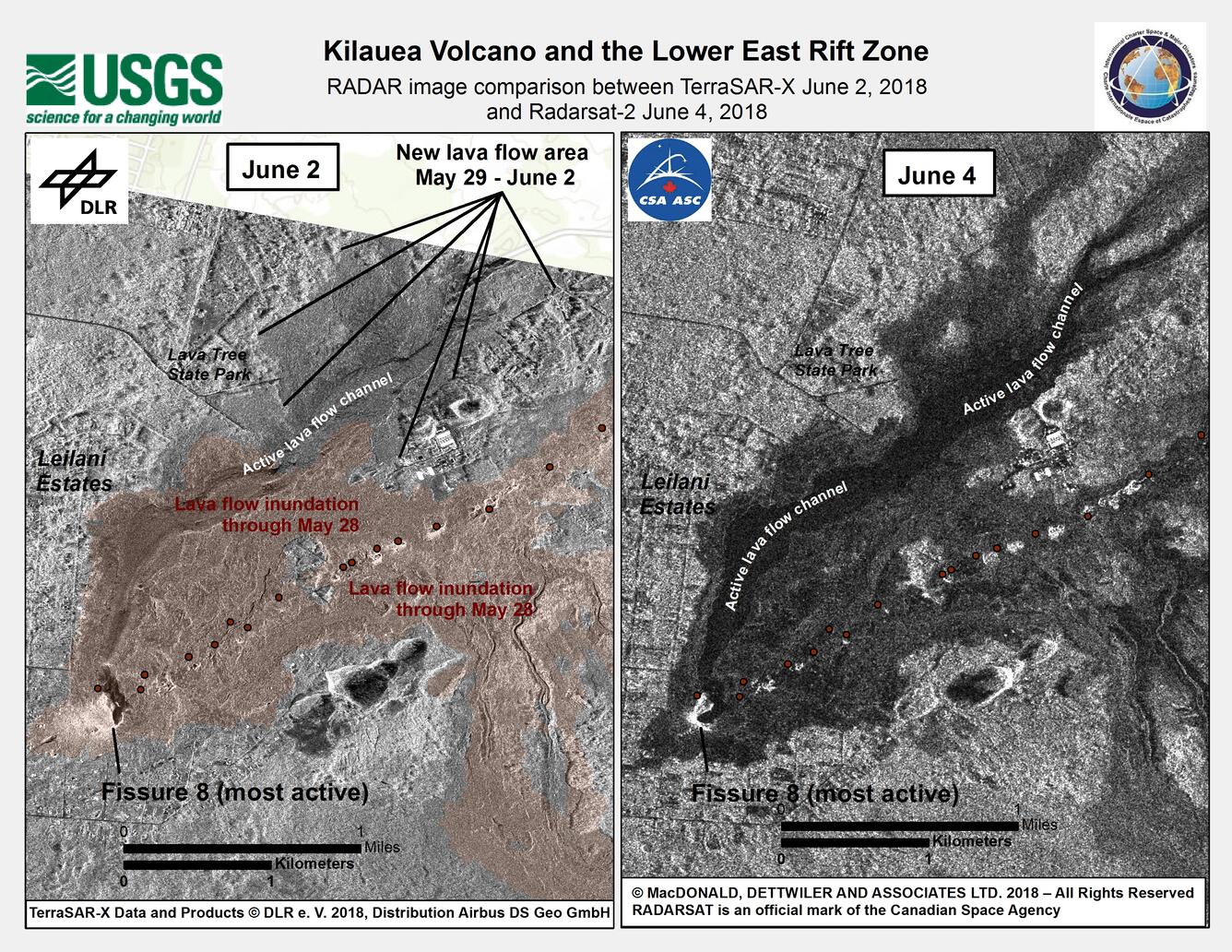
The International Charter for Space and Major Disasters (https://disasterscharter.org/) is a means for space agencies around the world to help with disaster monitoring by providing satellite data to responders and scientists on the ground. The charter was invoked for recent eruptive activity at Kīlauea, and numerous space agencies are providing satellite imagery that HVO scientists are using to help evaluate eruptive activity. In this example, high-resolution radar data from the German TerraSAR-X satellite acquired on June 2 (left) and from the Canadian RADARSAT-2 satellite on June 4 (right) show the area of the Fissure 8 lava flow, which appears as a darkened area in both images. We are grateful to our colleagues and partners at space agencies worldwide for their help in better tracking activity at Kīlauea.
HVO's mid-day overflight on June 5 shows ongoing partial collapse of Halema‘uma‘u at the summit of Kīlauea Volcano. To the north of the former visitor Overlook parking area (closed in 2008) is the site of the former lava lake—now a deep hole piled with wall-rock rubble. The western portion of Halema‘uma‘u has moved down and toward the center of the crater as new cracks form on the caldera floor to the west. Kīlauea's summit continues to subside due to withdrawal of magma towards the volcano's East Rift Zone.
Robust fissure 8 lava channels and ocean entry plume
This view, looking south at Kīlauea's lower East Rift Zone, was captured during HVO's 6:00 a.m. HST helicopter overflight today. It shows continued fountaining of fissure 8 and the lava flow channel fed by it. Lava continues to flow quickly in these braided channels; the flow margins are currently stable and have not experienced any breakouts since June 5.
This fish-eye view of the lava delta filling the former Kapoho Bay shows that while the delta margin nearest the ocean has cooled somewhat, the lava flow front is still very hot and producing laze (lava haze). Laze is a local hazard composed of acidic gases and volcanic glass fragments and should be avoided.
A robust laze (lava haze) plume rises from the northern side of the fissure 8 lava flow margins in the former Kapoho Bay. As of 6:00 AM HST on June 6, this part of the flow front was slowly advancing through the remaining sections of the Kapoho Beach Lots subdivision.
UAS hovering over active lava channel helps in estimating flow velocity
A UAS (Unmanned Aircraft Systems) conducts a mission in Kīlauea Volcano's lower East Rift Zone to collect video of flowing lava in fissure 8's upper lava channel. The video was used by scientists to assess lava flow velocities. Velocity is measured by tracking surface features in the stationary video view. UAS offers an advantage for this type of investigation because it can hover above hazardous areas and utilizes stabilized gimbals and mounts so that the video captured by onboard HD cameras is steady and smooth. Information obtained from this mission was relayed to emergency officials to aid in issuing emergency alerts and notices about the timing of evacuations. Video by the U.S. Geological Survey and Office of Aviation Services, Department of the Interior, with support from the Hawaiian Volcano Observatory.
Video from morning helicopter overflight traces lava's path to the sea
This is a video compilation from a helicopter overflight of Kīlauea Volcano's lower East Rift Zone on June 6, 2018, around 6:30 AM. The video shows the fissure 8 lava fountain feeding a channelized lava flow that travels northeast around the Kapoho cone, and then flows toward the south to enter the ocean at Kapoho Bay and Vacationland. The ocean entry has completely filled Kapoho Bay with lava, building a delta that extends 0.8 miles from shore.
Views from HVO's helicopter overflight at 1PM HST, show the remains of the Kapoho Beach Lots subdivision and the fissure 8 flow front. The northern flow margin in this area was unchanged from HVO's morning flight and appeared to have stopped advancing at the time of the flight.
3D thermal map of the new geometry of Halema‘uma‘u Crater
This 3D thermal map shows the new geometry of Halema‘uma‘u Crater. Magma in the summit magma chamber has drained over the past month due to the Lower East Rift Zone eruption, causing much of the floor and rim of Halema‘uma‘u to drop or collapse. These changes have resulted in a much deeper crater, with rubble covering the floor. The deepest part of the crater is 280 m (920 ft) below the former level of the crater floor.
Get Our News
These items are in the RSS feed format (Really Simple Syndication) based on categories such as topics, locations, and more. You can install and RSS reader browser extension, software, or use a third-party service to receive immediate news updates depending on the feed that you have added. If you click the feed links below, they may look strange because they are simply XML code. An RSS reader can easily read this code and push out a notification to you when something new is posted to our site.