An official website of the United States government
Here's how you know
Official websites use .gov
A .gov website belongs to an official government organization in the United States.
Secure .gov websites use HTTPS
A lock () or https:// means you’ve safely connected to the .gov website. Share sensitive information only on official, secure websites.
This image shows radar data acquired by the European Space Agency's Sentinel-1 satellite over Kīlauea Volcano on May 19 at 6:30 PM HST (left) compared to May 25 at 6:30 PM HST (right). The satellite transmits a radar signal toward the surface and measures the strength of the return, with bright areas indicating a strong return and dark areas a weak return. Strong returns indicate rough surfaces or slopes that point back at the radar, while weak returns come from smooth surfaces or slopes angled away from the radar.Comparing the two images shows that the summit eruptive vent continues to expand as the unsupported conduit walls collapse. As of the afternoon of May 25, the vent expansion included not only continued westward growth of the vent rim, but also a subsidiary pit on the north part of the floor of Halema‘uma‘u crater. The vent area is now approximately 90 acres, and we anticipate further enlargements over the coming days to weeks as subsidence of Kīlauea caldera, rockfalls, and small explosions continue.
Eruption continues from fissure complex, lower East Rift Zone
Pāhoehoe lava advancing west from fissure 7 (lava fountain in background) on Leilani Avenue. Fissure 7 activity increased overnight, with lava fountains reaching 50 to 60 m (164 to 197 ft) high.
Dramatic lava fountains at fissure 6 on Kīlauea Volcano's lower East Rift Zone on May 23, 2018, around 9:30 p.m. HST, are compared in the final frames of this video to the inactive fissure three days later (May 26, 2018, at 5:11 p.m. HST).
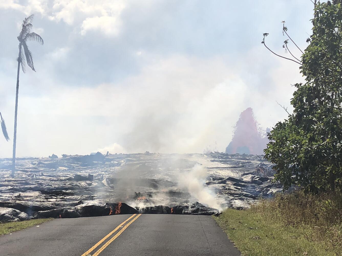
Downrift view of fissure 7 and a line of low lava fountains on Kīlauea Volcano's lower East Rift Zone. Fissure 7 activity increased overnight, with lava fountains reaching 150-200 feet high and producing a large spatter rampart over 100 feet tall. The fountains fed a perched pāhoehoe flow 20-40 feet thick, and a flow that ultimately turned south toward the coast.
Aerial view of the ocean-entry areas at about 12:30 p.m. HST. Lava flowing into the ocean diminished overnight and this morning (note lack of obvious plume at the entry areas). View is toward the northwest. Photograph courtesy of Civil Air Patrol.
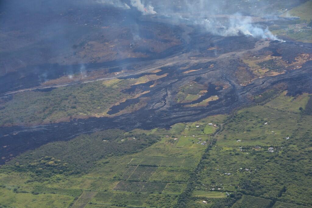
Aerial view of the eastern-most end of the fissure complex (top right) and active lava channels and inactive flows south of the fissures (toward left side of photo) at about 12:30 p.m. HST; the ocean is out of view left side of photo. In this view, fissure 22 in top right is supplying most of the lava to the active channel. Photograph courtesy of Civil Air Patrol.
Aerial view of Kīlauea Volcano's summit caldera and an ash plume billowing from Halema‘uma‘u, a crater within the caldera. The USGS–Hawaiian Volcano Observatory and Hawai‘i Volcanoes National Park's Jaggar Museum are visible on the caldera rim (center right); Kīlauea Military Camp can be seen in the lower right. Photo courtesy of the Civil Air Patrol.
On May 27, 2018, around noon, an ashy plume rose from the Overlook crater at Kīlauea Volcano’s summit. The base of the plume is about 600 m (2,000 ft) wide. The summit continues to subside in response to the withdrawal of magma. Rockfalls from the steep crater walls into the crater have produced explosions that send ash plumes to heights of 10,000 feet above sea level or higher.
UAS mission documents conditions at the Overlook vent
A UAS (Unmanned Aircraft Systems) mission during this past week documented the widening of the Overlook vent. Earthquakes in the Kīlauea Volcano's summit region continue as the area subsides and adjusts to the withdrawal of magma. The vent is widening due to the collapse of the steep enclosing walls and rim. Large rockfalls from these areas have triggered explosive events that produce minor amounts of ashfall downwind. The video surveys the southeast rim of the Overlook vent to the old Overlook parking lot, showing cracks in the rim and areas dusted with ash. Limited UAS flights into this hazardous area are conducted with permission and coordination with Hawai‘i Volcanoes National Park. The information is used to quantify change and informs our assessment of hazards, which is shared with the National Park Service and emergency managers. Footage is courtesy of the U.S. Department of the Interior Office of Aviation Services.
Get Our News
These items are in the RSS feed format (Really Simple Syndication) based on categories such as topics, locations, and more. You can install and RSS reader browser extension, software, or use a third-party service to receive immediate news updates depending on the feed that you have added. If you click the feed links below, they may look strange because they are simply XML code. An RSS reader can easily read this code and push out a notification to you when something new is posted to our site.