
Terrain features
Terrain features
Center of Excellence for Geospatial Information Science (CEGIS)
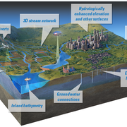
Terrain features refers to the land surface and its many components.
Terrain data, such as information about elevation, slope, aspect (the orientation of the land), can play an integral part in many land change and management studies.
These data are particularly useful in the form of digital elevation models (DEMs).


Knowledge extraction
Knowledge extraction
Filter Total Items: 1
Terrain features
Terrain refers to the land surface and its many components. Terrain data, such as information about elevation, slope, aspect (the orientation of the land), can play an integral part in many land change and management studies. These data are particularly useful in the form of digital elevation models (DEMs).