
USGS Science Collaboration Portal for the Colorado River Basin
Collaboration platform that brings together science, data, and mapping and analytical tools from across the basin
Collaboration platform that brings together science, data, and mapping and analytical tools from across the basin
Colorado River Basin Actionable and Strategic Integrated Science and Technology (ASIST) Initiative
Fostering Innovative Interdisciplinary Science for Characterizing and Adapting to Long-term Drought
Fostering Innovative Interdisciplinary Science for Characterizing and Adapting to Long-term Drought
Colorado River Basin Drought and the 2023 Water Year
Geonarrative presentation comparing 2023 conditions to the long-term drought in the Colorado River Basin
Geonarrative presentation comparing 2023 conditions to the long-term drought in the Colorado River Basin
Great Salt Lake Data and Reports by the USGS
Learn about Water Quantity and Quality and Aquatic Ecology of this National Treasure
Learn about Water Quantity and Quality and Aquatic Ecology of this National Treasure
Colorado River Basin Studies in Utah
Learn about Surface Water, Groundwater Quantities and Quality and Artificial Recharge of Groundwater in the Colorado River Basin in Utah
Learn about Surface Water, Groundwater Quantities and Quality and Artificial Recharge of Groundwater in the Colorado River Basin in Utah
Streamflow in the Upper Rio Grande Basin
USGS Analyses of the Effects of Potential Future Climate Conditions on Streamflows in the Upper Rio Grande Basin
USGS Analyses of the Effects of Potential Future Climate Conditions on Streamflows in the Upper Rio Grande Basin
Next Generation Water Observing System (NGWOS) Study: Upper Colorado River Basin
The USGS NGWOS Program Provides Innovative, High-fidelity, Real-time Data and Insightful Analyses about Water Quantity, Quality, and Use in Selected Watersheds across the U.S.
The USGS NGWOS Program Provides Innovative, High-fidelity, Real-time Data and Insightful Analyses about Water Quantity, Quality, and Use in Selected Watersheds across the U.S.
Rocky Mountain Region
USGS Region 7 Staff support and advise USGS Science Centers that provide numerous stakeholders with vital information about spatial distribution and temporal trends in critical minerals, energy resources, geology, water resources, native plants and wildlife, and hazards posed by earthquakes and landslides in Colorado, New Mexico, Utah, Wyoming and beyond.
USGS Region 7: Upper Colorado Basin (Rocky Mountain)
USGS Region 7: Upper Colorado Basin (Rocky Mountain)

Map Showing USGS/DOI Unified Region 7 and adjoining Regions
Key USGS Region 7 Contacts
Key USGS Region 7 Contacts
Additional Information about USGS Region 7
Additional Information about USGS Region 7
News
New Nationwide Tool Helps Answer: Do We Have Enough Water?
New Nationwide Tool Helps Answer: Do We Have Enough Water?
FORT Updates: From Plains to Peaks - Vol. 4 | Issue 1
FORT Updates: From Plains to Peaks - Vol. 4 | Issue 1
New tree-ring science demonstrates successful restoration of historical fire patterns in two southwestern wilderness areas
New tree-ring science demonstrates successful restoration of historical fire patterns in two southwestern wilderness areas
Publications
The United States Magnetotelluric Array and the National Impedance Map The United States Magnetotelluric Array and the National Impedance Map
The United States Magnetotelluric Array (USMTArray) data set, collected in the years 2006–2024, consists of more than 1,700 long-period magnetotelluric stations covering the entirety of the contiguous United States on a quasi-regular 70 km grid. Funding across multiple federal agencies was critical to sustaining this effort to its completion. Important components of the project included...
Springtime formation of laminated soil carbonate rinds and changes in fluvial terrace soils on orbital timescales at Rio Mesa, Utah, USA Springtime formation of laminated soil carbonate rinds and changes in fluvial terrace soils on orbital timescales at Rio Mesa, Utah, USA
Laminated soil carbonate rinds are a Quaternary paleoclimate archive whose isotope composition is linked to soil formation conditions. At Rio Mesa, Utah (USA), we investigated the fidelity of rind records in a river terrace setting by determining the seasonal timing of rind formation and testing for inter-record replication. We infer soil carbonate formed in the spring season...
Modeling chronic wasting disease transmission risk in mule deer related to habitat characteristics Modeling chronic wasting disease transmission risk in mule deer related to habitat characteristics
Chronic wasting disease (CWD) is a prion disease of cervids that spreads to uninfected individuals through direct transmission (contact with infected individuals), vertical transmission (from mother to offspring), or indirect transmission (exposure to contaminated environments). The risk of indirect transmission is unevenly distributed on the landscape, and risk levels are expected to be
Science
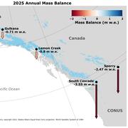
2025 USGS Benchmark Glaciers Executive Summary
2025 Data Now Available: Explore how the USGS Benchmark Glaciers have changed in 2025

Developing Science Plans for the Bureau of Land Management’s National Landscape Conservation System
The Bureau of Land Management’s National Landscape Conservation System seeks to conserve, protect, and restore nationally significant landscapes. Science is a critical piece of this effort. The US Geological Survey is working with the Bureau of Land Management to develop Science Plans to help prioritize and support science efforts to better understand and manage resources in these landscapes.

Land Treatment Exploration Tool
The Land Treatment Exploration Tool provides a practical resource for managers who are planning restoration and rehabilitation actions on public lands. The tool generates a variety of spatial products while being user friendly for all levels of GIS expertise, even to those with little or no experience.