Data Science: Converting Data into Actionable Knowledge
Science Analytics and Synthesis (SAS)
USGS Library
Core Science Systems Mission Area
USGS CSS serves as the primary national civilian mapping agency, including topographic and geologic mapping for Federal and State requirements, national geospatial coordination, satellite operations and remote sensing. Our products and data are necessary to understand, monitor, and detect changes that affect the Nation’s natural and agricultural resources, the economy, public safety, and security.
National Geospatial Program

The National Geospatial Program is the Federal civilian mapping agency and provides the digital geospatial foundation for the Nation. It engages partners and communities of use to collaboratively produce consistent and accurate topographic map data.
Science Synthesis, Analysis and Research Program

The Science Synthesis Analysis, and Research (SSAR) Program provides analysis and synthesis of scientific data and information, interdisciplinary research to improve understanding of Earth system changes, and preservation of scientific data and samples and library collections.
News
USGS Seeks Industry Input on Landsat 10 Mission Operations Center and Flight Operations
Released: NASA Goddard Issues Draft Request for Proposal for the Landsat 10 Spacecraft
Our Research on a Tire Chemical and its Impact on Fish Featured in LakeLine Magazine
Publications
ECCOE Landsat quarterly calibration and validation report—Quarter 4, 2025 ECCOE Landsat quarterly calibration and validation report—Quarter 4, 2025
System characterization report on Tanager System characterization report on Tanager
Adapting wildfire risk assessment for a Tribal landscape: Mount Baldy and the Fort Apache Reservation in Arizona Adapting wildfire risk assessment for a Tribal landscape: Mount Baldy and the Fort Apache Reservation in Arizona
Science
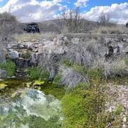
Las Moras Wash Restoration: Integrated Geomorphic Assessment, Modeling, Monitoring, and Adaptive Management

Fire Science