JACIE 2026 Workshop
April 13-17, 2026 — USGS Headquarters in Reston, Virginia, USA
How can I learn more about remote sensing satellite missions?
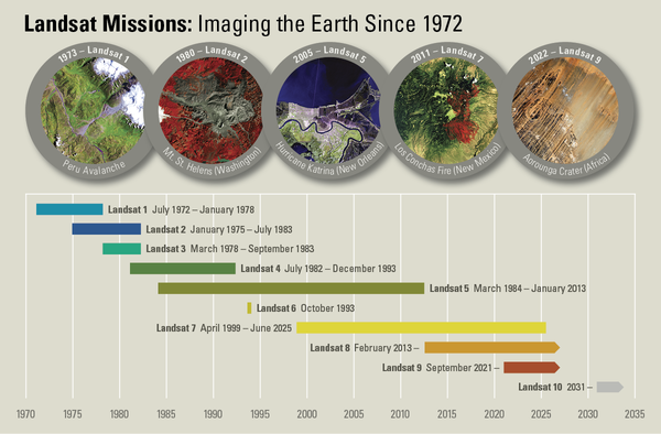
This comprehensive resource covers technical details for nearly 700 past, current and future land remote sensing satellites and their sensors.
Spectral Characteristics Viewer
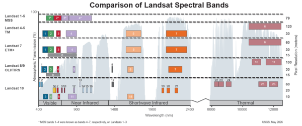
Which satellite bands are best suited for your research?
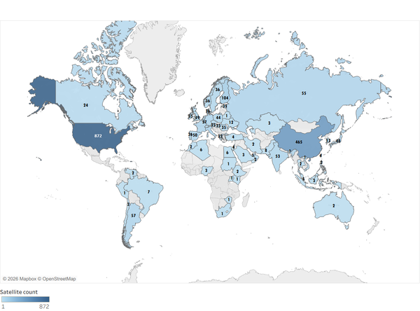
Worldwide Test Site Catalog
The BigMAC exercise
A 2021 Landsat surface product validation instrumentation campaign
Landsat Collection 2
Includes updated global digital elevation modeling sources, absolute geolocation accuracy, and interoperability improvements
EROS CalVal Center of Excellence (ECCOE)
The EROS Cal/Val Center of Excellence (ECCOE) is a global leader in improving the accuracy, precision, and quality of remote sensing data. ECCOE experts provide support to Landsat Calibration/Validation, Uncrewed Aircraft Systems, Lidar-3DEP, and Satellite Derived Bathymetry activities.
Landsat Calibration and Validation

The USGS ECCOE Landsat Cal/Val Team, along with their NASA counterparts, maintains primary responsibility for radiometric and geometric characterization and the calibration and validation of the Landsat instruments and spacecrafts.
The Team continually monitors the geometric and radiometric performance of active Landsat missions and makes calibration adjustments as needed to maintain data quality at the highest level. Results of the analysis are summarized in quarterly USGS Open File Reports.
This work includes both the ongoing operations of active Landsat missions, as well as the retired Landsat missions.
Visit the Landsat Calibration and Validation webpage to learn more.
Joint Agency Commercial Imagery Evaluation (JACIE)
The Joint Agency Commercial Imagery Evaluation (JACIE) was formed to leverage resources from several Federal agencies for the characterization of remote sensing data and to share those results across the remote sensing community. Consisting of representatives from six Federal agencies, JACIE provides independent characterizations of image and image-derived end products.
JACIE is the strong collaboration and enhanced working relationships between government and non-governmental organizations to understand remote sensing information and make it more useful to the user community. JACIE Workshops are held each year.
Visit the JACIE webpages to learn more.
Earth Observing Satellites Online Compendium

The JACIE Earth Observing Satellites Online Compendium contains details about past, present and future Earth observing satellites and the sensors they carry.
Derived from print versions of Compendiums published in 2019, 2020, and 2022, this resource has been developed and is managed by the Requirements, Capabilities and Analysis for Earth Observation (RCA-EO) team at the USGS EROS Center in Sioux Falls, South Dakota.
Access the Earth Observing Satellites Online Compendium
Lidar

Lidar data and their derivative metrics are fundamental inputs to many areas of scientific research, including flood, erosion, and coastal modeling and mapping, fault detection, land-surface mapping, landslide and volcano hazards, and mapping forest canopy.
Uncrewed Aerial Systems

Three-dimensional (3D) data capture technologies continue to become more commonplace, as Uncrewed Aerial Systems (UAS) have become available.
UAS's allow for new opportunities for gathering data essential to land management and Earth science. The potential of these systems requires that they be able to reliably gather accurate data.
Learn more about Uncrewed Aerial Systems
Test Sites Catalog

The USGS ECCOE Test Sites Catalog began in 2007 to provide information about effective radiometric, geometric, and spatial qualities useful in the calibration of Earth observation sensors. The catalog now contains prime candidate test sites worldwide for the calibration and post-launch characterization of space-based optical imaging sensors. The number of Earth-observing sensors and their derived science products continue to grow rapidly.
Accurate, well-documented calibration is needed to understand and address local and global science and societal impacts and benefits.
News
Latest in Landsat June 2026 - Vol. 5 | Issue 6
Latest in Landsat May 2026 - Vol. 5 | Issue 5
Satellite Data and Science Abound in 2025
Publications
System characterization report on Tanager System characterization report on Tanager
Landsat 8–9 geometric and radiometric calibration and characterization Landsat 8–9 geometric and radiometric calibration and characterization
ECCOE Landsat Quarterly Calibration and Validation Report—Quarter 2, 2025 ECCOE Landsat Quarterly Calibration and Validation Report—Quarter 2, 2025
Science

Eyes on Earth Episode 136 – The EROS Test Site

Eyes on Earth Episode 134 – Data Accuracy: The Calibration and Validation of Landsat