

Women have been crucial to the EROS workforce from the very beginning in a variety of areas, from customer service and computers to film processing and administration.
EROS History: Archive Unveils Earth’s Secrets
Time, precision, consistency key to scientific benefits
Time, precision, consistency key to scientific benefits
By Earth Resources Observation and Science (EROS) Center
August 26, 2024
Archive: The word evokes stacks of dusty papers, white-gloved scholars paging through books, crates of hidden treasure.
But the EROS archive is a dynamic, ever-evolving recreation of Earth through imagery—a time-travel treasure scientists wield to forecast fire, watch over water, predict famine, protect resources.
It is the largest civilian collection of remote sensing data on the planet.
Hidden Depths
Hidden Depths
We invite you to explore the archive of the U.S. Geological Survey’s Earth Resources Observation and Science (EROS) Center. EROS’ archive is the designated central location for all civilian federal remotely sensed satellite data, officially titled the National Satellite Land Remote Sensing Data Archive, established by Congress in 1992.
While the 50-plus years of Landsat data remain the powerhouse of the collection, our entire archive dates back to before satellites existed. EROS’ oldest collection starts with aerial photographs from 1937. Photos from sister agencies like NASA, the USDA and the Bureau of Land Management are also stored at EROS.
Scroll down to learn the full story—and don’t miss our archive timeline and “By the Numbers” section!
BACKGROUND: An uncrewed aerial systems (UAS) image of algal blooms on Milford Lake in Kansas, part of the Earth As Art 6 collection.
Sources/Usage: Public Domain. View Media Details


Landsat Proves Its Worth
Landsat Proves Its Worth

Sources/Usage: Public Domain. View Media Details
Every collection of imagery stored at EROS has value, but Landsat plays the starring role for many reasons. The chief one is the 50-plus-year history of satellite missions—from Landsat 1 through today’s near-twin Landsats 8 and 9—continuously mapping Earth along the same polar orbits.
This consistency through time enables our ability to track changes on the Earth’s surface. Reservoirs grow and shrink. Exotic grasses encroach upon sagebrush. Cities expand. Fires and volcanoes scar the landscape, and then we see as seasons change and years go by, the ecosystems recover.
EROS collects and processes satellite data into highly accurate imagery. Scientists at EROS and elsewhere analyze the imagery to help identify, track and predict changes in water, fire, ground cover, infrastructure and more. Governments, first responders, land managers and public and private entities use satellite data to help make land, water and wildlife management decisions every day.
A 2019 study showed Landsat’s economic benefit worldwide totals \$3.45 billion, with more than \$2 billion in the United States alone. Here are just a few of those benefits:
Helping the World Through Science
Helping the World Through Science
Helping the World Through Science
Mapping Land Cover and Change
Mapping Land Cover and Change
Mapping Land Cover and Change
The Color of Water with Landsat
The Color of Water with Landsat
The Color of Water with Landsat
New Ways to Measure Ocean Depth
New Ways to Measure Ocean Depth
New Ways to Measure Ocean Depth
Eight Decades of Aerial Imagery
Eight Decades of Aerial Imagery

Sources/Usage: Public Domain. View Media Details
Before Landsat 1 (then called ERTS 1) launched, EROS staff honed their photo development and interpretation skills with existing federal and state aerial photography. They had plenty of material—in fact, it was decades before Landsat scenes outnumbered aerial shots! And collections kept rolling in over time.
Imagery from airplanes complements Landsat imagery. Since airplanes pre-date satellites, our ability to view land change, both natural and human caused, extends back to 1937 in some places.
Read on to see examples of how aerial imagery stored at EROS teaches us more about land change, even helping restore an ecosystem on private land.
Sources/Usage: Public Domain. View Media Details
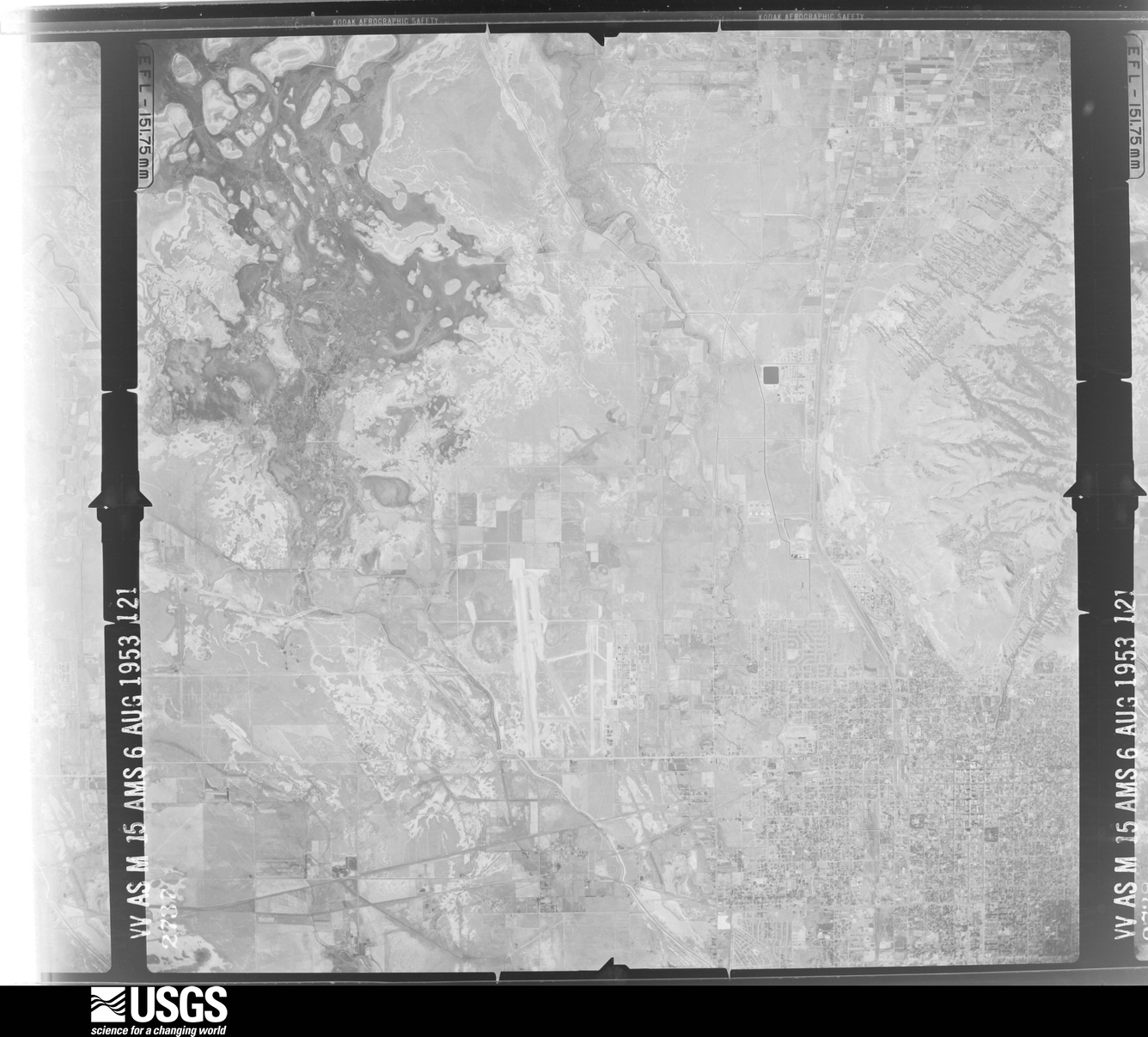
Army Map Service
In the 1950s, the Army Map Service (AMS) took detailed photos from aircraft to map the United States. The goal was to be prepared in case of a military invasion. A University of Montana project used that imagery to create Landscape Explorer, a tool to show how land has changed since the 1950s.
The website allows you to enter in a location, like your hometown, then links directly to the USGS archive, allowing you to compare the AMS version of the same spot in the 1950s. The comparison of images sheds light on growth of cities and other changes to the landscape for conservation purposes, to name a few examples. Today, the AMS images are available in the EROS archive. They cover the Great Plains to the West Coast. This photo is of Salt Lake City, Utah.
Visit the Landscape Explorer website to learn more.
NHAP, NAPP and NAIP
Several national aerial datasets are stored in the EROS archive: National High Altitude Photography (NHAP), National Aerial Photography Program (NAPP) and National Aerial Imagery Program (NAIP).
When a Minnesota scientist bought land in northeast Iowa, he noticed soggy patches on his property. Aerial photography from 1949 showed that a spring-fed brook had previously run through the field.
This USGS EROS Image of the Week video shows the restoration of the brook. Learn more about each of these collections in our timeline below.
BACKGROUND: A color infrared image of Little Rock, Arkansas, from 2001, taken as part of NAPP.
Sources/Usage: Public Domain. View Media Details

Declassified Images
Declassified Images
During the Cold War, classified military satellite reconnaissance programs codenamed CORONA, ARGON and LANYARD collected imagery of potential geopolitical hotspots in places like the Middle East, Soviet Union and China from 1960-1972. Eventually, the photos were declassified, and EROS received rolls of film from these programs starting in 1996.
Rolls of higher-resolution Gambit/Hexagon declassified photography, acquired 1963-1984, were added to the archive as late as 2019. Almost 60,000 high-resolution declassified images are freely available to download via USGS on EarthExplorer. Because of processing costs, the remainder of the 1.4 million scenes is available by order only. Once ordered, the scans become available in the archive.
Keep scrolling to learn how some researchers have used the declassified images.

Sources/Usage: Public Domain. View Media Details
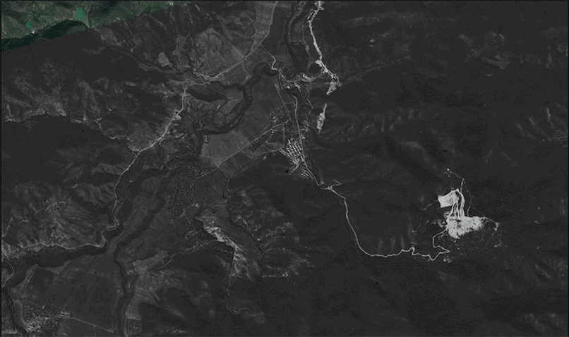
Finding Roman Forts
Using declassified CORONA imagery archived at EROS, Cambridge archaeologists zoomed in on Syria, Iraq and Jordan to study ancient Roman forts. They found hundreds of new sites and developed a new theory about the forts’ purpose—protecting commerce along trade routes.
Sources/Usage: Public Domain. View Media Details
Aftereffects of Chaotic Times
Wildlife ecologist Volker Radeloff compared high-resolution CORONA photography to Landsat imagery to study how landscapes changed in the aftermath of the Cold War in areas of the former Soviet Union. His goal? Predicting land use changes after calamities.
BACKGROUND: A view of the Forbidden City in Beijing, China, in 1966 from declassified satellite imagery stored in the archive at the USGS EROS Center.
Sources/Usage: Public Domain. View Media Details

Our Data Through History
Our Data Through History

Sources/Usage: Public Domain. View Media Details
EROS acquires about 1,500 Landsat scenes daily, a reliable, steady flow of data. But the history of our growth is full of surprising jumps and sudden changes, including retrieving millions of scenes from Landsat ground stations around the globe starting in 2010!
Our timeline highlights key additions to the collection. It also shows changes in data storage, data processing, data use and data accessibility—including the transformational decision in 2008 to provide remotely sensed data at no cost.
The growth of the film archive is not linear. The EROS archive grew by boxes, pallets and truckloads of film. Even Landsat came in with spurts of deliveries—the first two rolls of 70 mm film were hand-carried to EROS via Northwest Airlines.
—Tim Smith, KBR Inc., Information Management Services, contractor to USGS EROS Center


Archive Facts & Figures
Archive Facts & Figures

Sources/Usage: Public Domain. View Media Details
What's Next for the Archive?
What's Next for the Archive?
Landsat Next is expected to bring a data avalanche when its three satellites launch in about 2030. Landsat Next will capture a complete picture of the Earth every six days. It will deliver an additional 15 bands of data on top of Landsat's existing 11 bands.
To be fully prepared for the influx of data, EROS leaders are evaluating storage and processing options on premises and in the cloud.
Landsat Next
Landsat Next
“Landsat Next, to me, is an incredible mission … I really think of it as a game changer. The measurements provided to the community not only provide continuity with our current 52-year plus archive, but also drive new and emerging applications and science research. Landsat Next isn’t just a one-time science mission. It’s a global land survey mission, and it’s going to monitor our planet to further quantify and understand changes.”
— Brian Sauer, USGS Landsat Next Project Manager
Podcast
Listen to an Eyes on Earth episode highlighting preparations for data acquisition for Landsat Next:

Sources/Usage: Public Domain. View Media Details
Sources/Usage: Public Domain. View Media Details

More about EROS History
More about EROS History
Trio of Stories about EROS History
Trio of Stories about EROS History
Trio of Stories about EROS History
Data at No Cost
Data at No Cost
Data at No Cost
EROS 50th History Website
EROS 50th History Website
EROS 50th History Website
Related Content
Listen to podcasts and watch videos about USGS EROS.

Eyes on Earth Episode 100 – EROS 50th: Our Legacy
As USGS EROS turns 50 this month, our Eyes on Earth podcast also marks a big moment: Episode 100. To celebrate, we bring together some treasured moments from previous episodes in which people inside and outside of EROS share their thoughts on EROS and its role in the world of remote sensing, including as keeper of all Landsat satellite data.
Eyes on Earth Episode 115 – EROS Women in Science
Women have been crucial to the EROS workforce from the very beginning in a variety of areas, from customer service and computers to film processing and administration.

Eyes on Earth Episode 112 - Landsat in Popular Media
In this episode of Eyes on Earth, we aim to separate science fiction from science fact when it comes to how Landsat satellites and the EROS Center are portrayed in popular media. To do that, we consulted experts on a range of potential uses, including military, heat signatures, paleontology, and forests.
In this episode of Eyes on Earth, we aim to separate science fiction from science fact when it comes to how Landsat satellites and the EROS Center are portrayed in popular media. To do that, we consulted experts on a range of potential uses, including military, heat signatures, paleontology, and forests.

Eyes on Earth Episode 104 – EROS 50th: Alumni and Friends, Part 2
At the USGS EROS 50th anniversary events on August 17-19, 2023, a special effort was made to include alumni who had worked at the center, especially those from the earliest years of EROS’ existence. This episode of Eyes on Earth is the second to highlight their stories, with emphasis on science, technology, and EROS’ international outlook.
At the USGS EROS 50th anniversary events on August 17-19, 2023, a special effort was made to include alumni who had worked at the center, especially those from the earliest years of EROS’ existence. This episode of Eyes on Earth is the second to highlight their stories, with emphasis on science, technology, and EROS’ international outlook.

Eyes on Earth Episode 103 - EROS 50th: Alumni and Friends, Part 1
At the USGS EROS 50th anniversary events on August 17-19, 2023, a special effort was made to include alumni who had worked at the center, especially those from the earliest years of EROS’ existence. This episode of Eyes on Earth highlights their stories, with emphasis on EROS’ history and its dedicated employees.
At the USGS EROS 50th anniversary events on August 17-19, 2023, a special effort was made to include alumni who had worked at the center, especially those from the earliest years of EROS’ existence. This episode of Eyes on Earth highlights their stories, with emphasis on EROS’ history and its dedicated employees.

USGS EROS: Celebrating 50 Years of Excellence
For 50 years, the people of EROS have overcome difficulties and celebrated triumphs together, always centered on providing a perspective of the Earth that helps us better understand its condition. This video, timed with the 50th anniversary celebration at EROS in August of 2023, explores the center's history.
For 50 years, the people of EROS have overcome difficulties and celebrated triumphs together, always centered on providing a perspective of the Earth that helps us better understand its condition. This video, timed with the 50th anniversary celebration at EROS in August of 2023, explores the center's history.

EROS Radome: 20 Things You Didn't Know
Landsat satellites move in a polar orbit from north to south at over 27,000 kilometers per hour. For the ten meter antenna at EROS, a typical flyover, also known as a pass, lasts 14 minutes from horizon to horizon.
Landsat satellites move in a polar orbit from north to south at over 27,000 kilometers per hour. For the ten meter antenna at EROS, a typical flyover, also known as a pass, lasts 14 minutes from horizon to horizon.

Eyes on Earth Episode 93 – EROS 50th: Film Scanning
Working with film has always been part of EROS’ 50-year history. How did EROS end up with an extensive film archive, and how are we making that data available to users? In this episode of Eyes on Earth, we talk about the custom scanners built in-house from discarded parts to digitally capture historical aerial photos and declassified spy satellite images.
Working with film has always been part of EROS’ 50-year history. How did EROS end up with an extensive film archive, and how are we making that data available to users? In this episode of Eyes on Earth, we talk about the custom scanners built in-house from discarded parts to digitally capture historical aerial photos and declassified spy satellite images.

Eyes on Earth Episode 81 - Tour of the EROS Radome
The Landsat satellites have been collecting Earth imagery for more than 50 years. A key piece of equipment that moves the data from the spacecraft to the archive so researchers can use it is the antenna at the EROS Center. The antenna and its radome have a fascinating history of their own that adds to the overall Landsat story.
The Landsat satellites have been collecting Earth imagery for more than 50 years. A key piece of equipment that moves the data from the spacecraft to the archive so researchers can use it is the antenna at the EROS Center. The antenna and its radome have a fascinating history of their own that adds to the overall Landsat story.

Eyes on Earth Episode 79 – Landsat Global Archive Consolidation
The Landsat archive at EROS contains an unparalleled 50 years of Earth observation data. But with earlier technologies, some Landsat scenes were collected and stored only by international ground receiving stations rather than in the central archive at EROS.
The Landsat archive at EROS contains an unparalleled 50 years of Earth observation data. But with earlier technologies, some Landsat scenes were collected and stored only by international ground receiving stations rather than in the central archive at EROS.

Eyes on Earth Episode 78 - Landsat 50 Lookback
Government officials and scientists had high hopes for Landsat when the first experimental satellite launched July 23, 1972. Those hopes were soon realized when imagery came back depicting features never before seen. Since then, an archive of imagery surpassing 10 million scenes has amassed at EROS, collected from eight different Landsat satellites.
Government officials and scientists had high hopes for Landsat when the first experimental satellite launched July 23, 1972. Those hopes were soon realized when imagery came back depicting features never before seen. Since then, an archive of imagery surpassing 10 million scenes has amassed at EROS, collected from eight different Landsat satellites.

Outreach EROS Overview
This is EROS.
It's located just north of Sioux Falls in South Dakota in the United States on the planet Earth!
This is EROS.
It's located just north of Sioux Falls in South Dakota in the United States on the planet Earth!

USGS EROS | How To Search and Download Satellite Imagery
Learn more about the history of EROS and how to access the archive.

USGS EROS Celebrates 50 Years of a Mission that Matters
Fifty years ago, the U.S. Geological Survey (USGS) brought people together to work in a new government facility surrounded by South Dakota farm fields. The mission: act as stewards for land remote sensing imagery, especially the scenes collected by the fledgling Landsat satellite, and help people around the world make sense of it to benefit themselves and the planet.
Related Content
Listen to podcasts and watch videos about USGS EROS.
Eyes on Earth Episode 100 – EROS 50th: Our Legacy
As USGS EROS turns 50 this month, our Eyes on Earth podcast also marks a big moment: Episode 100. To celebrate, we bring together some treasured moments from previous episodes in which people inside and outside of EROS share their thoughts on EROS and its role in the world of remote sensing, including as keeper of all Landsat satellite data.
Eyes on Earth Episode 115 – EROS Women in Science
Women have been crucial to the EROS workforce from the very beginning in a variety of areas, from customer service and computers to film processing and administration.
Women have been crucial to the EROS workforce from the very beginning in a variety of areas, from customer service and computers to film processing and administration.
Eyes on Earth Episode 112 - Landsat in Popular Media
In this episode of Eyes on Earth, we aim to separate science fiction from science fact when it comes to how Landsat satellites and the EROS Center are portrayed in popular media. To do that, we consulted experts on a range of potential uses, including military, heat signatures, paleontology, and forests.
In this episode of Eyes on Earth, we aim to separate science fiction from science fact when it comes to how Landsat satellites and the EROS Center are portrayed in popular media. To do that, we consulted experts on a range of potential uses, including military, heat signatures, paleontology, and forests.
Eyes on Earth Episode 104 – EROS 50th: Alumni and Friends, Part 2
At the USGS EROS 50th anniversary events on August 17-19, 2023, a special effort was made to include alumni who had worked at the center, especially those from the earliest years of EROS’ existence. This episode of Eyes on Earth is the second to highlight their stories, with emphasis on science, technology, and EROS’ international outlook.
At the USGS EROS 50th anniversary events on August 17-19, 2023, a special effort was made to include alumni who had worked at the center, especially those from the earliest years of EROS’ existence. This episode of Eyes on Earth is the second to highlight their stories, with emphasis on science, technology, and EROS’ international outlook.
Eyes on Earth Episode 103 - EROS 50th: Alumni and Friends, Part 1
At the USGS EROS 50th anniversary events on August 17-19, 2023, a special effort was made to include alumni who had worked at the center, especially those from the earliest years of EROS’ existence. This episode of Eyes on Earth highlights their stories, with emphasis on EROS’ history and its dedicated employees.
At the USGS EROS 50th anniversary events on August 17-19, 2023, a special effort was made to include alumni who had worked at the center, especially those from the earliest years of EROS’ existence. This episode of Eyes on Earth highlights their stories, with emphasis on EROS’ history and its dedicated employees.
USGS EROS: Celebrating 50 Years of Excellence
For 50 years, the people of EROS have overcome difficulties and celebrated triumphs together, always centered on providing a perspective of the Earth that helps us better understand its condition. This video, timed with the 50th anniversary celebration at EROS in August of 2023, explores the center's history.
For 50 years, the people of EROS have overcome difficulties and celebrated triumphs together, always centered on providing a perspective of the Earth that helps us better understand its condition. This video, timed with the 50th anniversary celebration at EROS in August of 2023, explores the center's history.
EROS Radome: 20 Things You Didn't Know
Landsat satellites move in a polar orbit from north to south at over 27,000 kilometers per hour. For the ten meter antenna at EROS, a typical flyover, also known as a pass, lasts 14 minutes from horizon to horizon.
Landsat satellites move in a polar orbit from north to south at over 27,000 kilometers per hour. For the ten meter antenna at EROS, a typical flyover, also known as a pass, lasts 14 minutes from horizon to horizon.
Eyes on Earth Episode 93 – EROS 50th: Film Scanning
Working with film has always been part of EROS’ 50-year history. How did EROS end up with an extensive film archive, and how are we making that data available to users? In this episode of Eyes on Earth, we talk about the custom scanners built in-house from discarded parts to digitally capture historical aerial photos and declassified spy satellite images.
Working with film has always been part of EROS’ 50-year history. How did EROS end up with an extensive film archive, and how are we making that data available to users? In this episode of Eyes on Earth, we talk about the custom scanners built in-house from discarded parts to digitally capture historical aerial photos and declassified spy satellite images.
Eyes on Earth Episode 81 - Tour of the EROS Radome
The Landsat satellites have been collecting Earth imagery for more than 50 years. A key piece of equipment that moves the data from the spacecraft to the archive so researchers can use it is the antenna at the EROS Center. The antenna and its radome have a fascinating history of their own that adds to the overall Landsat story.
The Landsat satellites have been collecting Earth imagery for more than 50 years. A key piece of equipment that moves the data from the spacecraft to the archive so researchers can use it is the antenna at the EROS Center. The antenna and its radome have a fascinating history of their own that adds to the overall Landsat story.
Eyes on Earth Episode 79 – Landsat Global Archive Consolidation
The Landsat archive at EROS contains an unparalleled 50 years of Earth observation data. But with earlier technologies, some Landsat scenes were collected and stored only by international ground receiving stations rather than in the central archive at EROS.
The Landsat archive at EROS contains an unparalleled 50 years of Earth observation data. But with earlier technologies, some Landsat scenes were collected and stored only by international ground receiving stations rather than in the central archive at EROS.
Eyes on Earth Episode 78 - Landsat 50 Lookback
Government officials and scientists had high hopes for Landsat when the first experimental satellite launched July 23, 1972. Those hopes were soon realized when imagery came back depicting features never before seen. Since then, an archive of imagery surpassing 10 million scenes has amassed at EROS, collected from eight different Landsat satellites.
Government officials and scientists had high hopes for Landsat when the first experimental satellite launched July 23, 1972. Those hopes were soon realized when imagery came back depicting features never before seen. Since then, an archive of imagery surpassing 10 million scenes has amassed at EROS, collected from eight different Landsat satellites.
Outreach EROS Overview
This is EROS.
It's located just north of Sioux Falls in South Dakota in the United States on the planet Earth!
This is EROS.
It's located just north of Sioux Falls in South Dakota in the United States on the planet Earth!
USGS EROS | How To Search and Download Satellite Imagery
Learn more about the history of EROS and how to access the archive.
USGS EROS Celebrates 50 Years of a Mission that Matters
Fifty years ago, the U.S. Geological Survey (USGS) brought people together to work in a new government facility surrounded by South Dakota farm fields. The mission: act as stewards for land remote sensing imagery, especially the scenes collected by the fledgling Landsat satellite, and help people around the world make sense of it to benefit themselves and the planet.
Get Our News
These items are in the RSS feed format (Really Simple Syndication) based on categories such as topics, locations, and more. You can install and RSS reader browser extension, software, or use a third-party service to receive immediate news updates depending on the feed that you have added. If you click the feed links below, they may look strange because they are simply XML code. An RSS reader can easily read this code and push out a notification to you when something new is posted to our site.