


ECOSTRESS, or ECOsystem Spaceborne Thermal Radiometer Experiment on Space Station, data provides variables related to plant water stress, including evapotranspiration, evaporative stress index and water use efficiency. The NASA Land Processes Distributed Active Archive Center (LP DAAC) at EROS provides storage and distribution of ECOSTRESS data.
NASA Archive Evolves While Still Calling USGS Home
The LP DAAC and EROS both benefit from their connections
The LP DAAC and EROS both benefit from their connections
By Earth Resources Observation and Science (EROS) Center
February 4, 2025
A U.S. Geological Survey (USGS) building in rural South Dakota might seem like an unusual setting for people from across the country to gather and offer input for a NASA endeavor. But the visit to the NASA Land Processes Distributed Active Archive Center (LP DAAC) there highlighted a number of ways the USGS intertwines with NASA to produce and support remote sensing data.
NASA established the LP DAAC at the USGS Earth Resources Observation and Science (EROS) Center more than three decades ago to manage some data from its Earth Observing System (EOS). But NASA’s roots at EROS run even deeper: The center began as NASA’s archive partner in the 52-year-old Landsat satellite program.
Media

Sources/Usage: Public Domain. View Media Details
About 40 USGS EROS federal and contract employees provide the workforce for the LP DAAC, which archives NASA-funded land data from sensors located on satellites and the International Space Station. Some LP DAAC employees first worked at other positions at EROS, which has expanded from its initial archive purpose into Landsat satellite operations and science applications. Similarly, some previous LP DAAC employees have shifted into other departments at EROS.
Today, data from both the LP DAAC and USGS EROS archives are used by scientists in government agencies, universities and other organizations around the world to monitor and make decisions about topics that range from agriculture and wildfires to urban planning, flooding and hotspot detections.
The recent LP DAAC Annual User Working Group (UWG) Meeting at EROS spotlighted just a few of the many uses for remote sensing data. The LP DAAC UWG is made up of 15 representatives in various career stages at universities, government agencies and commercial endeavors whose work involves using LP DAAC data, tools and resources.
The data come from well-known sensors such as the Moderate Resolution Imaging Spectroradiometer (MODIS) and newer sensors like the Global Ecosystem Dynamics Investigation (GEDI). The LP DAAC also archives the Harmonized Landsat Sentinel-2 (HLS) data, produced from a combination of data from Landsat satellites and European Sentinel-2 satellites.
Some LP DAAC users also use EROS-generated data—commonly Landsat, but also science products like the National Land Cover Database (NLCD), now called Annual NLCD; LANDFIRE (Landscape Fire and Resource Management Planning Tools); and Monitoring Trends in Burn Severity (MTBS).
‘Tons of Connections’ Between LP DAAC Users and EROS
Media

Sources/Usage: Public Domain. View Media Details
The User Working Group was designed to help the LP DAAC learn more about current and future user needs and to collect feedback on how to better support user communities. The working group learned, too—from updates about changes at the LP DAAC and NASA’s 11 other Distributed Active Archive Centers around the country to status reports about the LP DAAC’s active sensors.
They also heard about Landsat updates and were given an overview of the science work at EROS. EROS employees were invited to attend as well to become more familiar with the LP DAAC.
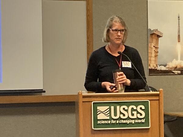
“Hosting at EROS gives us a unique opportunity to kind of expand our User Working Group, because you’ve got the USGS science projects that are also users of LP DAAC data. There’s tons of connections. And then it’s kind of a two-way street because I’ve also got UWG members that are using LANDFIRE data and a lot using Landsat data,” said USGS LP DAAC Project Scientist Cole Krehbiel.
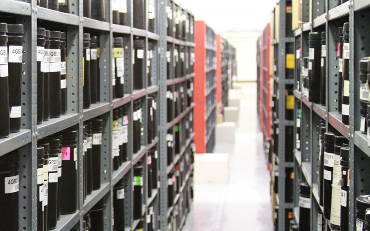
The User Working Group members who attended in person learned more about the EROS archive (below left) firsthand as they were led on a basement tour showing aisles and aisles of shelves loaded with older media containing Landsat and aerial imagery. “It’s funny that the basement is always everyone’s favorite, I think, and seeing those old rolls of film,” Krehbiel said.
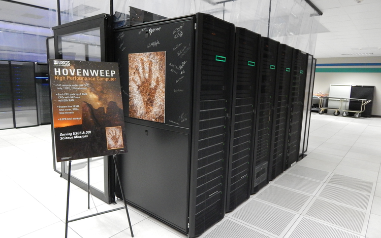
In technological contrast, they also viewed supercomputers, available for use by USGS and other Department of Interior scientists, in a climate-controlled computer room at EROS (below right). The computer room also contains several storage racks of LP DAAC data—at least for now.
Updates on LP DAAC Data Access Efforts
Media
Sources/Usage: Public Domain. View Media Details
One LP DAAC update that the User Working Group heard about will affect those EROS computer room racks.
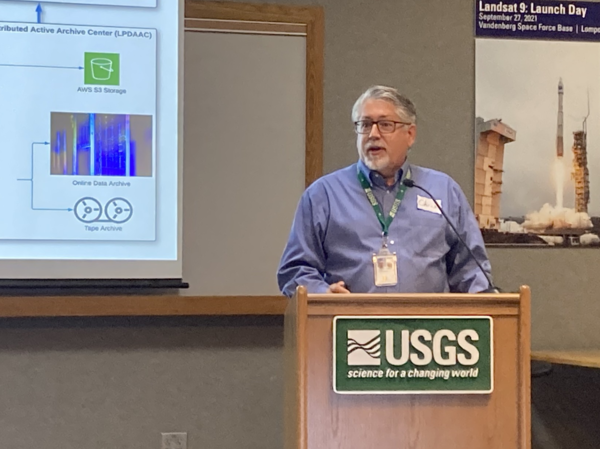
The LP DAAC has been in the process of moving its archive data into the commercial cloud environment for several years so it can be more interoperable, or more easily used in combination with other datasets by scientists. “Datasets are important on their own and stand alone. But they’re better together,” said Chris Torbert, USGS Project Manager for the LP DAAC.
The vast majority of the LP DAAC data that users work with has now been moved to the cloud, the User Working Group was informed, and the LP DAAC will reduce its physical storage footprint at EROS within a year. Still taking up room at EROS for a couple of years will be data from the Advanced Spaceborne Thermal Emission and Reflection Radiometer (ASTER) sensor, which launched in 1999. At the conclusion of a processing effort to create a collection in the cloud of all the ASTER data, that data will be removed physically from EROS, too.
Another update provided to the User Working Group included the LP DAAC’s web presence, which soon will shift from an individual website managed by the USGS to a unified NASA website with the other DAACs. LP DAAC data is accessed through the LP DAAC-developed AppEEARS (Application for Extracting and Exploring Analysis Ready Samples) tool, which serves several other DAACs, too. AppEEARS also currently offers Landsat U.S. Analysis Ready Data (ARD) Surface Reflectance products; integrating those data into AppEEARS was a recommendation from the UWG and a collaborative effort between USGS EROS and the LP DAAC.
AppEEARS provides access, processing and visualization of popular LP DAAC data all in one spot. The LP DAAC wants to explore adding other EROS data products, in addition to Landsat ARD, to AppEEARS for the convenience of its user community using multiple datasets. At the top of the wish list from the UWG was the Annual NLCD products, which the LP DAAC plans to integrate into AppEEARS this year.
EROS Scientist Joins User Working Group
Media
Sources/Usage: Public Domain. View Media Details
Among the LP DAAC User Working Group’s newest members is EROS’ own Birgit Peterson, a USGS supervisory geographer and the fire science team lead in the Integrated Science and Applications Branch. Peterson uses GEDI data that’s stored in the LP DAAC to get a three-dimensional view of vegetation that can act as fuel for fires and help indicate how a fire would behave in a forest, for example.
Attending the LP DAAC meeting was eye-opening for Peterson, who had given little thought to how the data she downloaded and used became available. Now, she realizes, “there’s a whole science behind it. There’s a whole technology. It makes me want to go out and try different ways to get at some of the data that were talked about.”
Times have changed for the better, she said. “The level of thought that is being put into how we get data out there, just comparing back to 10, 15, close to 20 years ago, has improved so dramatically.”
Peterson hopes to not only represent her own project interests on the User Working Group, but also help represent the perspective of scientists she knows who, with severely limited time, need remote sensing data to be easy to access and use.
“Birgit was an extremely good candidate with her experience with the LANDFIRE program and also wildfire management, fire ecology and those sorts of things,” Krehbiel said. “We were definitely interested in bringing someone into the User Working Group to represent EROS because it is such a huge user community.”
Big Developments Expected for Data Management at EROS
Both the LP DAAC and USGS archive at EROS are looking forward to separate planned Earth observation missions that would significantly expand their data management work in coming years.
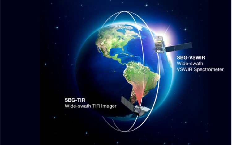
The Surface Biology and Geology (SBG) mission is building a new satellite with aspirations for a second, each collecting different data. “I would say, for 30 years, by and large, the LP DAAC has been the MODIS and ASTER DAAC. That’s really been our identity,” Torbert said. “In the future, it’s SBG.”
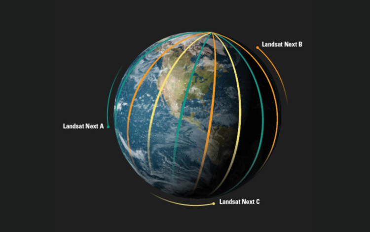
Meanwhile, the next iteration of Landsat satellites, labeled Landsat Next, is planned to be a constellation of three satellites offering more frequent revisit times around the Earth than previous Landsat satellites. Landsat Next is expected to collect about 20 times the amount of data collected by its predecessor, Landsat 9, which is currently orbiting with Landsat 8.
“To have Landsat Next and SBG both be managed at USGS EROS is a huge accomplishment, and we should be very proud of our center for that,” Krehbiel said.
Related
Listen to Eyes on Earth podcast episodes based on data managed by the LP DAAC.
Eyes on Earth Episode 83 - ECOSTRESS and Burn Severity
Eyes on Earth is a podcast on remote sensing, Earth observation, land change and science, brought to you by the USGS Earth Resources Observation and Science (EROS) Center. In this episode, we learn about the usefulness of ECOSTRESS data in examining predictors for wildfire burn patterns.
Eyes on Earth Episode 82 - Introduction to GEDI
Eyes on Earth is a podcast on remote sensing, Earth observation, land change and science, brought to you by the USGS Earth Resources Observation and Science (EROS) Center. In this episode, we learn about the purpose of the GEDI mission on the International Space Station and what is being learned from it.
Eyes on Earth Episode 80 – ECOSTRESS and Carbon
Eyes on Earth is a podcast on remote sensing, Earth observation, land change and science, brought to you by the USGS Earth Resources Observation and Science (EROS) Center. In this episode, we learn about the role ECOSTRESS temperature measurements played in a study of the carbon dioxide exchange in and around Los Angeles.
Eyes on Earth Episode 77 – ECOSTRESS and Urban Heat
Eyes on Earth is a podcast on remote sensing, Earth observation, land change and science, brought to you by the USGS Earth Resources Observation and Science (EROS) Center. In this episode, we learn about tracking urban heat from space.
Eyes on Earth Episode 76 – ECOSTRESS and Disease Risk
Eyes on Earth is a podcast on remote sensing, Earth observation, land change and science, brought to you by the USGS Earth Resources Observation and Science (EROS) Center. In this episode, we learn how measurements from space can track risk of mosquito-borne disease.
Eyes on Earth Episode 75 – Mapping Dust Sources Worldwide
Eyes on Earth is a podcast on remote sensing, Earth observation, land change and science, brought to you by the USGS Earth Resources Observation and Science (EROS) Center. In this episode, we hear about a mission to map the Earth’s minerals from above.
Eyes on Earth Episode 70 - ECOSTRESS and Aquatic Ecosystems
Eyes on Earth is a podcast on remote sensing, Earth observation, land change and science, brought to you by the USGS Earth Resources Observation and Science (EROS) Center. In this episode, we learn how space-based measurements of water temperature can help manage invasive species.
Eyes on Earth Episode 67 - ECOSTRESS and Water Use
Eyes on Earth is a podcast on remote sensing, Earth observation, land change and science, brought to you by the USGS Earth Resources Observation and Science (EROS) Center. In this episode, we learn how the ECOSTRESS sensor can track water use efficiency.
Eyes on Earth Episode 63 - ECOSTRESS and Post-Fire Recovery
Eyes on Earth is a podcast on remote sensing, Earth observation, land change and science, brought to you by the USGS Earth Resources Observation and Science (EROS) Center. In this episode, we learn how a new spaceborne sensor aids the study of wildfire recovery.
Listen to podcasts related to data managed by the LP DAAC.
Eyes on Earth Episode 83 - ECOSTRESS and Burn Severity
ECOSTRESS, or ECOsystem Spaceborne Thermal Radiometer Experiment on Space Station, data provides variables related to plant water stress, including evapotranspiration, evaporative stress index and water use efficiency. The NASA Land Processes Distributed Active Archive Center (LP DAAC) at EROS provides storage and distribution of ECOSTRESS data.

Eyes on Earth Episode 82 - Introduction to GEDI
The Global Ecosystem Dynamics Investigation, or GEDI, instrument on the International Space Station acquires lidar waveforms to observe the Earth’s surface in 3D. The GEDI lidar measures the height and density of objects, so it provides information such as surface elevation and tree canopy height and cover.
The Global Ecosystem Dynamics Investigation, or GEDI, instrument on the International Space Station acquires lidar waveforms to observe the Earth’s surface in 3D. The GEDI lidar measures the height and density of objects, so it provides information such as surface elevation and tree canopy height and cover.

Eyes on Earth Episode 80 - ECOSTRESS and Carbon
ECOSTRESS, which stands for the ECOsystem Spaceborne Thermal Radiometer Experiment on Space Station, collects land surface temperatures in an effort to answer questions about plants’ use of water. The NASA Land Processes Distributed Active Archive Center (LP DAAC) at EROS has provided storage and distribution of ECOSTRESS data for four years now and counting.
ECOSTRESS, which stands for the ECOsystem Spaceborne Thermal Radiometer Experiment on Space Station, collects land surface temperatures in an effort to answer questions about plants’ use of water. The NASA Land Processes Distributed Active Archive Center (LP DAAC) at EROS has provided storage and distribution of ECOSTRESS data for four years now and counting.

Eyes on Earth Episode 77 – ECOSTRESS and Urban Heat
We don't need a scientist to tell us that city streets catch and hold heat. Anyone who's walked barefoot from a parking lot to a beach can tell you that. What scientists can help us understand, particularly scientists who work with spaceborne, remotely sensed data, is just how big a difference there is between cities and the countryside.
We don't need a scientist to tell us that city streets catch and hold heat. Anyone who's walked barefoot from a parking lot to a beach can tell you that. What scientists can help us understand, particularly scientists who work with spaceborne, remotely sensed data, is just how big a difference there is between cities and the countryside.

Eyes on Earth Episode 76 – ECOSTRESS and Disease Risk
Spaceborne sensors orbit hundreds of miles over our heads. Even the most advanced among them struggle to capture high-resolution imagery of individual human beings. Mosquitos, of course, are far smaller than we are. Clearly, sensors on a satellite or space station can’t see them.
Spaceborne sensors orbit hundreds of miles over our heads. Even the most advanced among them struggle to capture high-resolution imagery of individual human beings. Mosquitos, of course, are far smaller than we are. Clearly, sensors on a satellite or space station can’t see them.

Eyes on Earth Episode 75 – Mapping Dust Sources Worldwide
Clouds of dust kicked up in places like the Sahara can travel thousands of miles across the planet. We can see those clouds in satellite imagery, but we don’t typically know much about the composition of that dust. That’s a huge blind spot, because those unknown characteristics—such as the particles’ lightness or darkness—have an impact on what they do.
Clouds of dust kicked up in places like the Sahara can travel thousands of miles across the planet. We can see those clouds in satellite imagery, but we don’t typically know much about the composition of that dust. That’s a huge blind spot, because those unknown characteristics—such as the particles’ lightness or darkness—have an impact on what they do.

Eyes on Earth Episode 70 - ECOSTRESS and Aquatic Ecosystems
Summary: The Earth observation data archived here have plenty of value to the study of aquatic ecosystems. Landsat satellites can capture harmful algal blooms, for example. Spaceborne sensors can also record land surface temperatures, and that includes water surfaces.
Summary: The Earth observation data archived here have plenty of value to the study of aquatic ecosystems. Landsat satellites can capture harmful algal blooms, for example. Spaceborne sensors can also record land surface temperatures, and that includes water surfaces.

Eyes on Earth Episode 67 - ECOSTRESS and Water Use
If you want to know how much rain fell yesterday, you can catch it and measure it. Water vapor? That's not so easy. Which is a problem if you want to know how quickly that rate is returning to the atmosphere. Water vapor is the single largest part of the water budget, but without space-based observations, it would be all but impossible to measure at wide scale.
If you want to know how much rain fell yesterday, you can catch it and measure it. Water vapor? That's not so easy. Which is a problem if you want to know how quickly that rate is returning to the atmosphere. Water vapor is the single largest part of the water budget, but without space-based observations, it would be all but impossible to measure at wide scale.

Eyes on Earth Episode 63 – ECOSTRESS and Post-Fire Recovery
Fires can be destructive or healthy for a landscape—often both. Fires have grown larger and more destructive in recent years, though, thanks to human activity, climate change, and a host of other factors. Satellite data helps us to map and monitor fire activity, but the study of post-fire plant life using remote sensing data goes further than fire mapping.
Fires can be destructive or healthy for a landscape—often both. Fires have grown larger and more destructive in recent years, though, thanks to human activity, climate change, and a host of other factors. Satellite data helps us to map and monitor fire activity, but the study of post-fire plant life using remote sensing data goes further than fire mapping.

Eyes on Earth Episode 45 - Harmonized Landsat-Sentinel
Landsat satellites have monitoring the Earth’s surface for nearly 50 years, providing critical information for countless areas of study and real-world applications. But with observations only collected every 8-16 days, there are limits to what can be tracked.
Landsat satellites have monitoring the Earth’s surface for nearly 50 years, providing critical information for countless areas of study and real-world applications. But with observations only collected every 8-16 days, there are limits to what can be tracked.
Learn more about the LP DAAC, its work and its connections to the USGS.

EROS 50th History: Adding the LP DAAC Archive
An original purpose of the USGS Earth Resources Observation and Science (EROS) Center, 50 years ago when the facility was planted in the middle of farm fields, was to store and send out land remote sensing data to anyone in the world with an interest in using it.
Related
Listen to Eyes on Earth podcast episodes based on data managed by the LP DAAC.
Eyes on Earth Episode 83 - ECOSTRESS and Burn Severity
Eyes on Earth is a podcast on remote sensing, Earth observation, land change and science, brought to you by the USGS Earth Resources Observation and Science (EROS) Center. In this episode, we learn about the usefulness of ECOSTRESS data in examining predictors for wildfire burn patterns.
Eyes on Earth Episode 82 - Introduction to GEDI
Eyes on Earth is a podcast on remote sensing, Earth observation, land change and science, brought to you by the USGS Earth Resources Observation and Science (EROS) Center. In this episode, we learn about the purpose of the GEDI mission on the International Space Station and what is being learned from it.
Eyes on Earth Episode 80 – ECOSTRESS and Carbon
Eyes on Earth is a podcast on remote sensing, Earth observation, land change and science, brought to you by the USGS Earth Resources Observation and Science (EROS) Center. In this episode, we learn about the role ECOSTRESS temperature measurements played in a study of the carbon dioxide exchange in and around Los Angeles.
Eyes on Earth Episode 77 – ECOSTRESS and Urban Heat
Eyes on Earth is a podcast on remote sensing, Earth observation, land change and science, brought to you by the USGS Earth Resources Observation and Science (EROS) Center. In this episode, we learn about tracking urban heat from space.
Eyes on Earth Episode 76 – ECOSTRESS and Disease Risk
Eyes on Earth is a podcast on remote sensing, Earth observation, land change and science, brought to you by the USGS Earth Resources Observation and Science (EROS) Center. In this episode, we learn how measurements from space can track risk of mosquito-borne disease.
Eyes on Earth Episode 75 – Mapping Dust Sources Worldwide
Eyes on Earth is a podcast on remote sensing, Earth observation, land change and science, brought to you by the USGS Earth Resources Observation and Science (EROS) Center. In this episode, we hear about a mission to map the Earth’s minerals from above.
Eyes on Earth Episode 70 - ECOSTRESS and Aquatic Ecosystems
Eyes on Earth is a podcast on remote sensing, Earth observation, land change and science, brought to you by the USGS Earth Resources Observation and Science (EROS) Center. In this episode, we learn how space-based measurements of water temperature can help manage invasive species.
Eyes on Earth Episode 67 - ECOSTRESS and Water Use
Eyes on Earth is a podcast on remote sensing, Earth observation, land change and science, brought to you by the USGS Earth Resources Observation and Science (EROS) Center. In this episode, we learn how the ECOSTRESS sensor can track water use efficiency.
Eyes on Earth Episode 63 - ECOSTRESS and Post-Fire Recovery
Eyes on Earth is a podcast on remote sensing, Earth observation, land change and science, brought to you by the USGS Earth Resources Observation and Science (EROS) Center. In this episode, we learn how a new spaceborne sensor aids the study of wildfire recovery.
Listen to podcasts related to data managed by the LP DAAC.
Eyes on Earth Episode 83 - ECOSTRESS and Burn Severity
ECOSTRESS, or ECOsystem Spaceborne Thermal Radiometer Experiment on Space Station, data provides variables related to plant water stress, including evapotranspiration, evaporative stress index and water use efficiency. The NASA Land Processes Distributed Active Archive Center (LP DAAC) at EROS provides storage and distribution of ECOSTRESS data.
ECOSTRESS, or ECOsystem Spaceborne Thermal Radiometer Experiment on Space Station, data provides variables related to plant water stress, including evapotranspiration, evaporative stress index and water use efficiency. The NASA Land Processes Distributed Active Archive Center (LP DAAC) at EROS provides storage and distribution of ECOSTRESS data.
Eyes on Earth Episode 82 - Introduction to GEDI
The Global Ecosystem Dynamics Investigation, or GEDI, instrument on the International Space Station acquires lidar waveforms to observe the Earth’s surface in 3D. The GEDI lidar measures the height and density of objects, so it provides information such as surface elevation and tree canopy height and cover.
The Global Ecosystem Dynamics Investigation, or GEDI, instrument on the International Space Station acquires lidar waveforms to observe the Earth’s surface in 3D. The GEDI lidar measures the height and density of objects, so it provides information such as surface elevation and tree canopy height and cover.
Eyes on Earth Episode 80 - ECOSTRESS and Carbon
ECOSTRESS, which stands for the ECOsystem Spaceborne Thermal Radiometer Experiment on Space Station, collects land surface temperatures in an effort to answer questions about plants’ use of water. The NASA Land Processes Distributed Active Archive Center (LP DAAC) at EROS has provided storage and distribution of ECOSTRESS data for four years now and counting.
ECOSTRESS, which stands for the ECOsystem Spaceborne Thermal Radiometer Experiment on Space Station, collects land surface temperatures in an effort to answer questions about plants’ use of water. The NASA Land Processes Distributed Active Archive Center (LP DAAC) at EROS has provided storage and distribution of ECOSTRESS data for four years now and counting.
Eyes on Earth Episode 77 – ECOSTRESS and Urban Heat
We don't need a scientist to tell us that city streets catch and hold heat. Anyone who's walked barefoot from a parking lot to a beach can tell you that. What scientists can help us understand, particularly scientists who work with spaceborne, remotely sensed data, is just how big a difference there is between cities and the countryside.
We don't need a scientist to tell us that city streets catch and hold heat. Anyone who's walked barefoot from a parking lot to a beach can tell you that. What scientists can help us understand, particularly scientists who work with spaceborne, remotely sensed data, is just how big a difference there is between cities and the countryside.
Eyes on Earth Episode 76 – ECOSTRESS and Disease Risk
Spaceborne sensors orbit hundreds of miles over our heads. Even the most advanced among them struggle to capture high-resolution imagery of individual human beings. Mosquitos, of course, are far smaller than we are. Clearly, sensors on a satellite or space station can’t see them.
Spaceborne sensors orbit hundreds of miles over our heads. Even the most advanced among them struggle to capture high-resolution imagery of individual human beings. Mosquitos, of course, are far smaller than we are. Clearly, sensors on a satellite or space station can’t see them.
Eyes on Earth Episode 75 – Mapping Dust Sources Worldwide
Clouds of dust kicked up in places like the Sahara can travel thousands of miles across the planet. We can see those clouds in satellite imagery, but we don’t typically know much about the composition of that dust. That’s a huge blind spot, because those unknown characteristics—such as the particles’ lightness or darkness—have an impact on what they do.
Clouds of dust kicked up in places like the Sahara can travel thousands of miles across the planet. We can see those clouds in satellite imagery, but we don’t typically know much about the composition of that dust. That’s a huge blind spot, because those unknown characteristics—such as the particles’ lightness or darkness—have an impact on what they do.
Eyes on Earth Episode 70 - ECOSTRESS and Aquatic Ecosystems
Summary: The Earth observation data archived here have plenty of value to the study of aquatic ecosystems. Landsat satellites can capture harmful algal blooms, for example. Spaceborne sensors can also record land surface temperatures, and that includes water surfaces.
Summary: The Earth observation data archived here have plenty of value to the study of aquatic ecosystems. Landsat satellites can capture harmful algal blooms, for example. Spaceborne sensors can also record land surface temperatures, and that includes water surfaces.
Eyes on Earth Episode 67 - ECOSTRESS and Water Use
If you want to know how much rain fell yesterday, you can catch it and measure it. Water vapor? That's not so easy. Which is a problem if you want to know how quickly that rate is returning to the atmosphere. Water vapor is the single largest part of the water budget, but without space-based observations, it would be all but impossible to measure at wide scale.
If you want to know how much rain fell yesterday, you can catch it and measure it. Water vapor? That's not so easy. Which is a problem if you want to know how quickly that rate is returning to the atmosphere. Water vapor is the single largest part of the water budget, but without space-based observations, it would be all but impossible to measure at wide scale.
Eyes on Earth Episode 63 – ECOSTRESS and Post-Fire Recovery
Fires can be destructive or healthy for a landscape—often both. Fires have grown larger and more destructive in recent years, though, thanks to human activity, climate change, and a host of other factors. Satellite data helps us to map and monitor fire activity, but the study of post-fire plant life using remote sensing data goes further than fire mapping.
Fires can be destructive or healthy for a landscape—often both. Fires have grown larger and more destructive in recent years, though, thanks to human activity, climate change, and a host of other factors. Satellite data helps us to map and monitor fire activity, but the study of post-fire plant life using remote sensing data goes further than fire mapping.
Eyes on Earth Episode 45 - Harmonized Landsat-Sentinel
Landsat satellites have monitoring the Earth’s surface for nearly 50 years, providing critical information for countless areas of study and real-world applications. But with observations only collected every 8-16 days, there are limits to what can be tracked.
Landsat satellites have monitoring the Earth’s surface for nearly 50 years, providing critical information for countless areas of study and real-world applications. But with observations only collected every 8-16 days, there are limits to what can be tracked.
Learn more about the LP DAAC, its work and its connections to the USGS.
EROS 50th History: Adding the LP DAAC Archive
An original purpose of the USGS Earth Resources Observation and Science (EROS) Center, 50 years ago when the facility was planted in the middle of farm fields, was to store and send out land remote sensing data to anyone in the world with an interest in using it.
Get Our News
These items are in the RSS feed format (Really Simple Syndication) based on categories such as topics, locations, and more. You can install and RSS reader browser extension, software, or use a third-party service to receive immediate news updates depending on the feed that you have added. If you click the feed links below, they may look strange because they are simply XML code. An RSS reader can easily read this code and push out a notification to you when something new is posted to our site.