

First responders need reliable, accurate mapping capabilities as quickly as possible in the wake of a disaster—and they don’t have time to download and organize it.
USGS Staff Present at Natural Disasters Response Workshop
By Earth Resources Observation and Science (EROS) Center
May 30, 2024
When wildfires threaten homes and hurricanes ravage communities, satellite data are vital for relief efforts. Coordinating those resources is the mission of the 2024 Disaster Response/Data Mining Geospatial Workshop.
Various USGS Earth Resources Observation and Science (EROS) Center personnel will be there to present sessions and build relationships with other agencies and first responders.

Sources/Usage: Public Domain. View Media Details
Connecting Responders and Resources
EROS team members will present alongside other speakers from NASA, NOAA and the National Weather Service, FEMA and several Louisiana state agencies.
“It’s all about knowing what’s out there and how to access it when emergency managers are trying to deal with the immediate onset of a disaster event,” says Michael Budde of EROS.
In its 25th year, the disasters workshop has approximately 100 attendees traveling to the NASA Regional Application Center on the campus of the University of Louisiana, Lafayette, for the June 6 workshop. More than 50 attendees are signed up to participate virtually. Online registration for virtual attendance is still open.
“It’s a very well-organized meeting and draws on a wide variety of expertise from the Gulf states, particularly Louisiana,” says Budde, who will attend the workshop for the sixth time. “A unique aspect of this year’s workshop is that it will not only focus on hurricane preparedness but will also have a wildfire response component.”
Both Budde and Kurtis Nelson, a physical scientist with the USGS Wildland Fire Science Team, will talk about wildfire preparedness response and recovery data and tools available at EROS.
EROS Emergency Support
USGS Emergency Operations (EO) is the division at EROS dedicated to getting timely remote sensing data into the hands of agencies responding to disasters. At the Louisiana workshop, EO Coordinator Dean Mierau and Brenda Ellis, a contractor leading the EO Team at EROS, will give an overview of how it works.
When a disaster happens, the Hazards Data Distribution System (HDDS) at EROS provides a one-stop shop for agencies and governments that need quick access to remote sensing visuals. HDDS data is not just from Landsat or other sources in the EROS archive but from multiple government and even commercial databases.
The support during hazardous events doesn’t stop at the border. USGS is a member of the International Charter Space and Major Disasters, which means that any government agency around the world that needs remote sensing data can request assistance by activating the Charter. Budde, the USGS liaison to the International Charter, will present an overview of the Charter at the disasters workshop in addition to information about wildfire response.

Sources/Usage: Public Domain. View Media Details
More USGS Support
As a workshop highlight, Tim Newman, lead coordinator of the USGS National Land Imaging Program, will give an overview of Landsat Next, the next generation of satellites. The mission includes a constellation of three satellites with superspectral capabilities.
“Landsat Next is going to be more capable than Landsats 8 and 9, meeting far more user needs,” Newman said in a recent podcast. “It’s going to collect more detailed imagery more often for characterizing the Earth’s surface as it changes. These include applications across the farm belt, ranches, urban areas, coastal areas, and many other areas impacted by drought and wildfire.”
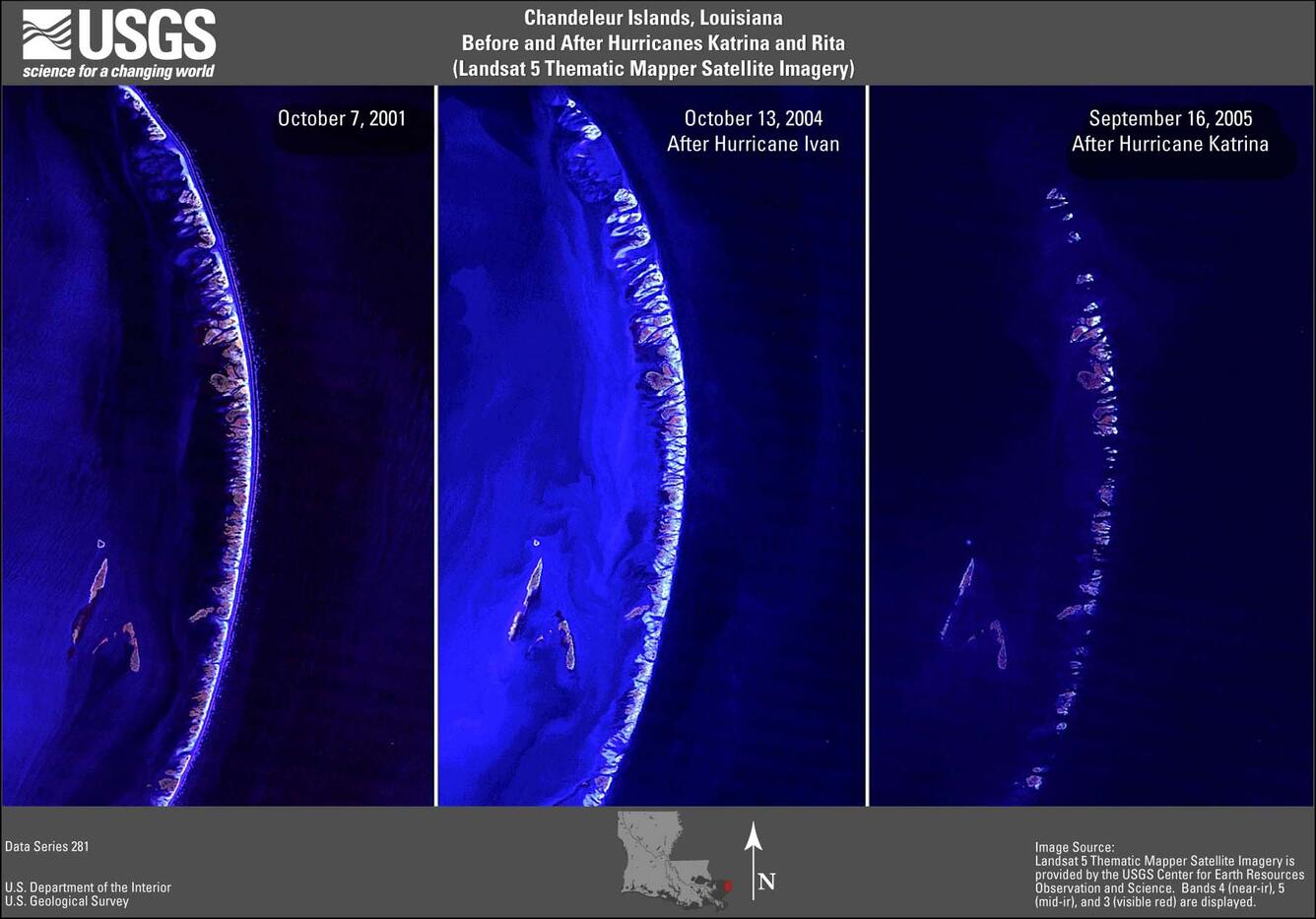
Next year, the disasters workshop will recognize the 20th anniversary of Hurricane Katrina, which devastated the Gulf of Mexico coastline in Louisiana and Mississippi.
Sources/Usage: Some content may have restrictions. View Media Details
Related Content
Listen to podcasts describing USGS efforts to share remote sensing data with first responders during a natural disaster.

Eyes on Earth Episode 36 – International Charter Turns 20
When a disaster like a hurricane, flood or major wildfire hits a remote part of the world, the International Charter Space and Natural Disasters springs into action.
Eyes on Earth Episode 110 – Geospatial Information Response Team
First responders need reliable, accurate mapping capabilities as quickly as possible in the wake of a disaster—and they don’t have time to download and organize it.
Learn more about the long history of disaster response support at EROS.

EROS 50th History: Responding to Disasters
Landsat satellites captured vivid imagery of the massive fires blazing across Canada earlier this year: orange flames, ugly burn scars, thick smoke.
The U.S. Geological Survey’s Earth Resources Observation and Science (EROS) Center was ready to share relevant images and data as quickly as possible to agencies responding to the fires.
Related Content
Listen to podcasts describing USGS efforts to share remote sensing data with first responders during a natural disaster.
Eyes on Earth Episode 36 – International Charter Turns 20
When a disaster like a hurricane, flood or major wildfire hits a remote part of the world, the International Charter Space and Natural Disasters springs into action.
Eyes on Earth Episode 110 – Geospatial Information Response Team
First responders need reliable, accurate mapping capabilities as quickly as possible in the wake of a disaster—and they don’t have time to download and organize it.
First responders need reliable, accurate mapping capabilities as quickly as possible in the wake of a disaster—and they don’t have time to download and organize it.
Learn more about the long history of disaster response support at EROS.
EROS 50th History: Responding to Disasters
Landsat satellites captured vivid imagery of the massive fires blazing across Canada earlier this year: orange flames, ugly burn scars, thick smoke.
The U.S. Geological Survey’s Earth Resources Observation and Science (EROS) Center was ready to share relevant images and data as quickly as possible to agencies responding to the fires.
Get Our News
These items are in the RSS feed format (Really Simple Syndication) based on categories such as topics, locations, and more. You can install and RSS reader browser extension, software, or use a third-party service to receive immediate news updates depending on the feed that you have added. If you click the feed links below, they may look strange because they are simply XML code. An RSS reader can easily read this code and push out a notification to you when something new is posted to our site.