
Coral Reef Project: Roi-Namur Island
The USGS is working to provide a better understanding of how spatially-varying atoll morphology and coral cover interact with changes in water level to affect the propagation of waves of different heights and wavelengths across atoll reefs.
Overview
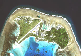
Roi-Namur is the northernmost and second largest island on Kwajalein Atoll, the largest coral atoll in the world. The atoll is in the Republic of the Marshall Islands, which is a self-governed and freely associated republic with the United States. The atoll lies near the equator about 3,900 km (2,100 mi) southwest of Hawaiʻi, and is comprised of 97 islands and islets. Originally two smaller islands, Roi on the west, and Namur on the east, the two were joined with fill during World War II. The single island now encompasses a total area of about 2.5 sq km (about 1 sq mi). Roi-Namur is known locally as “Roi.” Roi and several other islands on the atoll (including Kwajalein Island), are leased by the United States as part of the U.S. Army Kwajalein Atoll, part of the Ronald Reagan Ballistic Missile Defense Test Site formerly known as the Kwajalein Missile Range.
Motivation

Observations show that sea level is rising globally at a rate almost double the Intergovernmental Panel for Climate Change’s 2007 report, and up to half and order of magnitude greater in the central and western Pacific Ocean. Recent estimates suggest sea level will exceed 1.0 m, and may reach 2.0 m, above 2000 levels by the end of the 21st century. Sea-level rise is particularly critical for unconsolidated low-lying coral atoll islands, many of which have maximum elevations of less than 4 m above present sea level, such as Roi-Namur. These islands support 2000+ year-old cultures, yet the amount of land and water available for human habitation, water and food sources, and ecosystems is limited and extremely vulnerable to marine inundation from sea-level rise. Vertical coral reef flat accretion rates for coral reefs exposed to open-ocean storm waves (1 to 4 mm/yr) are up to an order of magnitude smaller than the rates of sea-level rise projected for the years 2000–2100 (8 to 16 mm/yr), therefore projected sea-level rise will outstrip potential new reef flat accretion, resulting in a net increase in water depth over exposed coral reef flats on the order of 0.4 to 1.5 m during the 21st century. The extreme vulnerability of these communities to changing oceanic and atmospheric conditions represents a serious threat through impacts on food and water security, public safety, and environmental health.

The USGS is working with Deltares, NOAA, and the U.S. Department of Defense to provide a better understanding of how spatially-varying atoll morphology and coral cover interact with changes in water level to affect the propagation of waves of different heights and wavelengths across atoll reefs. Such information is necessary to model how predicted sea-level rise and climate change may alter wave-driven inundation, and thus impacts to infrastructure, agriculture, and natural habitats, on low-lying atoll islands.
For additional information, visit the site, "The Impact of Sea-Level Rise and Climate Change on Pacific Ocean Atolls."
Learn more about coral reef and atoll studies at the USGS.


Below are news stories associated with this project.

The USGS is working to provide a better understanding of how spatially-varying atoll morphology and coral cover interact with changes in water level to affect the propagation of waves of different heights and wavelengths across atoll reefs.
Overview
Roi-Namur is the northernmost and second largest island on Kwajalein Atoll, the largest coral atoll in the world. The atoll is in the Republic of the Marshall Islands, which is a self-governed and freely associated republic with the United States. The atoll lies near the equator about 3,900 km (2,100 mi) southwest of Hawaiʻi, and is comprised of 97 islands and islets. Originally two smaller islands, Roi on the west, and Namur on the east, the two were joined with fill during World War II. The single island now encompasses a total area of about 2.5 sq km (about 1 sq mi). Roi-Namur is known locally as “Roi.” Roi and several other islands on the atoll (including Kwajalein Island), are leased by the United States as part of the U.S. Army Kwajalein Atoll, part of the Ronald Reagan Ballistic Missile Defense Test Site formerly known as the Kwajalein Missile Range.
Motivation
Observations show that sea level is rising globally at a rate almost double the Intergovernmental Panel for Climate Change’s 2007 report, and up to half and order of magnitude greater in the central and western Pacific Ocean. Recent estimates suggest sea level will exceed 1.0 m, and may reach 2.0 m, above 2000 levels by the end of the 21st century. Sea-level rise is particularly critical for unconsolidated low-lying coral atoll islands, many of which have maximum elevations of less than 4 m above present sea level, such as Roi-Namur. These islands support 2000+ year-old cultures, yet the amount of land and water available for human habitation, water and food sources, and ecosystems is limited and extremely vulnerable to marine inundation from sea-level rise. Vertical coral reef flat accretion rates for coral reefs exposed to open-ocean storm waves (1 to 4 mm/yr) are up to an order of magnitude smaller than the rates of sea-level rise projected for the years 2000–2100 (8 to 16 mm/yr), therefore projected sea-level rise will outstrip potential new reef flat accretion, resulting in a net increase in water depth over exposed coral reef flats on the order of 0.4 to 1.5 m during the 21st century. The extreme vulnerability of these communities to changing oceanic and atmospheric conditions represents a serious threat through impacts on food and water security, public safety, and environmental health.
The USGS is working with Deltares, NOAA, and the U.S. Department of Defense to provide a better understanding of how spatially-varying atoll morphology and coral cover interact with changes in water level to affect the propagation of waves of different heights and wavelengths across atoll reefs. Such information is necessary to model how predicted sea-level rise and climate change may alter wave-driven inundation, and thus impacts to infrastructure, agriculture, and natural habitats, on low-lying atoll islands.
For additional information, visit the site, "The Impact of Sea-Level Rise and Climate Change on Pacific Ocean Atolls."
Learn more about coral reef and atoll studies at the USGS.
Below are news stories associated with this project.