Investigation of Drivers of Harmful Algal Blooms on the Shenandoah River, Virginia
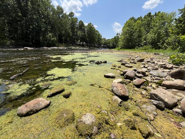
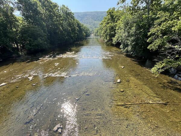
The U.S. Geological Survey (USGS), in cooperation with the Viriginia Department of Environmental Quality (DEQ) and collaboration with the Interstate Commission on the Potomac River Basin (ICPRB) is monitoring harmful algal blooms (HABs) on the two forks of the Shenandoah River in Virginia. Continuous and discrete water-quality and hydrology data is conducted to understand the drivers, persistence, and decline of HABs within the water column and on the streambed. Real-time sensors will be installed in the stream to detect and measure photosynthetic pigments and estimate the abundance of algal taxa in the water. The compiled data set will provide the foundational information about HABs to evaluate the causes and effects of many interacting factors over time.

Overview
Filamentous algae attached to the stream bottom has been a concern in the Shenandoah River basin for over a decade. Concerns have largely centered on the negative impact that filamentous algal blooms have on stream aesthetics and recreational activities such as swimming, wading, kayaking, and fishing. Harmful algal toxins were found in the North Fork Shenandoah River which caused a recreational advisory in over 52 miles of the river for people, pets, and livestock. Drinking water intakes were also affected along the rivers.
The factors and interactions of factors of HAB formation, persistence, and decline are not well understood. These factors can include nutrients, temperature, climate, hydrology, geochemistry, and light. A variety of sensors will be installed to record high-resolution data to distinguish different drivers, including a sensor to analyze nitrate, a type of nutrient, and a sensor to measure the amount of sunlight that could be used by algae to grow. Monthly synoptic sampling and surface-water/groundwater interactions will also be investigated to evaluate the factors that drive HABs formation.
Objectives
The objectives of this monitoring program are to:
- Inform the extent and risk of benthic HABs
- Identify and understand the factors and processes leading to HAB initiation, persistence, and decline
- Identify primary sources of the factors contributing to the formation of HABs
- Identify technologies or approaches to help predict or provide early detection of a HAB event
Active Monitoring Sites
Click the links below to view active site data:
- N F Shenandoah River Near Strasburg, VA – 01634000: 38.9767759, -78.3361152 Website: N F Shenandoah River Near Strasburg, VA - USGS Water Data for the Nation
- N F Shenandoah River at Mount Jackson, VA – 01633000: 38.74567048, -78.6389042 Website: N F Shenandoah River at Mount Jackson, VA - USGS Water Data for the Nation
- S F Shenandoah River Near Lynnwood, VA – 01628500: 38.32262796, -78.7547457 Website: S F Shenandoah River Near Lynnwood, VA - USGS Water Data for the Nation
- S F Shenandoah River Near Luray, VA – 01629500: 38.6462305, -78.5347329 Website: S F Shenandoah River Near Luray, VA - USGS Water Data for the Nation
Harmful Algal Blooms Investigations at the Virginia and West Virginia Water Science Center
Investigation of Drivers of Harmful Algal Blooms on Lake Anna, Virginia
Shenandoah HABS


The U.S. Geological Survey (USGS), in cooperation with the Viriginia Department of Environmental Quality (DEQ) and collaboration with the Interstate Commission on the Potomac River Basin (ICPRB) is monitoring harmful algal blooms (HABs) on the two forks of the Shenandoah River in Virginia. Continuous and discrete water-quality and hydrology data is conducted to understand the drivers, persistence, and decline of HABs within the water column and on the streambed. Real-time sensors will be installed in the stream to detect and measure photosynthetic pigments and estimate the abundance of algal taxa in the water. The compiled data set will provide the foundational information about HABs to evaluate the causes and effects of many interacting factors over time.

Overview
Filamentous algae attached to the stream bottom has been a concern in the Shenandoah River basin for over a decade. Concerns have largely centered on the negative impact that filamentous algal blooms have on stream aesthetics and recreational activities such as swimming, wading, kayaking, and fishing. Harmful algal toxins were found in the North Fork Shenandoah River which caused a recreational advisory in over 52 miles of the river for people, pets, and livestock. Drinking water intakes were also affected along the rivers.
The factors and interactions of factors of HAB formation, persistence, and decline are not well understood. These factors can include nutrients, temperature, climate, hydrology, geochemistry, and light. A variety of sensors will be installed to record high-resolution data to distinguish different drivers, including a sensor to analyze nitrate, a type of nutrient, and a sensor to measure the amount of sunlight that could be used by algae to grow. Monthly synoptic sampling and surface-water/groundwater interactions will also be investigated to evaluate the factors that drive HABs formation.
Objectives
The objectives of this monitoring program are to:
- Inform the extent and risk of benthic HABs
- Identify and understand the factors and processes leading to HAB initiation, persistence, and decline
- Identify primary sources of the factors contributing to the formation of HABs
- Identify technologies or approaches to help predict or provide early detection of a HAB event
Active Monitoring Sites
Click the links below to view active site data:
- N F Shenandoah River Near Strasburg, VA – 01634000: 38.9767759, -78.3361152 Website: N F Shenandoah River Near Strasburg, VA - USGS Water Data for the Nation
- N F Shenandoah River at Mount Jackson, VA – 01633000: 38.74567048, -78.6389042 Website: N F Shenandoah River at Mount Jackson, VA - USGS Water Data for the Nation
- S F Shenandoah River Near Lynnwood, VA – 01628500: 38.32262796, -78.7547457 Website: S F Shenandoah River Near Lynnwood, VA - USGS Water Data for the Nation
- S F Shenandoah River Near Luray, VA – 01629500: 38.6462305, -78.5347329 Website: S F Shenandoah River Near Luray, VA - USGS Water Data for the Nation
Harmful Algal Blooms Investigations at the Virginia and West Virginia Water Science Center
Investigation of Drivers of Harmful Algal Blooms on Lake Anna, Virginia
Shenandoah HABS


