
Probability of Streamflow Permanence (PROSPER)
Probability of Streamflow Permanence (PROSPER)
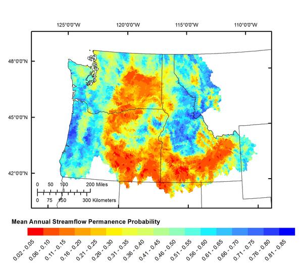
PROSPER is a spatially continuous model developed to predict if and where streams in the Pacific Northwest will cease to flow in any given year.
Rivers and streams are constantly changing. Streamflows can change throughout the year and between years due to snowmelt, precipitation, diversions, and return flows. For many streams, these fluctuations determine whether a stream has year-round flow or not. PRObability of Streamflow PERmanence (PROSPER) is a project initiated to better understand what causes these fluctuations in different hydrological settings.
PROSPER is an empirical model developed to predict if and where streams in the Pacific Northwest (western Montana, Idaho, Oregon, and Washington) will cease to flow in any given year. The model was calibrated with thousands of observations across the Pacific Northwest indicating whether a site had flow or not during the low-flow season. The contributing basins for the wet and dry observations were then characterized using annual or monthly climate data, such as precipitation and temperature, and physiographic characteristics, such as soil types. The model was then used to make predictions of the annual probability of year-round flow at 30-meter resolution for every stream in the Pacific Northwest for 2004-2016. Classification error was about 21 percent.

- PROSPER is a regionally consistent dataset representing probability of streamflow permanence at high spatial (30 meters) and temporal resolution (annual)
- The empirical model is calibrated using about 4,000 streamflow permanence observations and about 300 explanatory variables consisting of monthly or annually updated climate data and physiographic basin characteristics
- After calibration, the PROSPER model was able to correctly predict whether a site was wet or dry about 79 percent of the time based on internal cross-validation.
- Annual predictions for 2004-2016 can be obtained from StreamStats
- Ongoing work includes adding a springs dataset into the model, and working on making PROSPER a real-time prediction tool
- Developed Web apps for storing and collecting new streamflow permanence observations are available for Oregon, Idaho, and Washington
Details about the project are described in a webinar: Mapping and modeling annual probability of year-round streamflow, 2004-2016: A case study in the Pacific Northwest.

Results
After calibration, the PROSPER model was able to correctly predict whether a site was wet or dry about 79 percent of the time based on internal cross-validation (results are from averages across 12-digit Hydrologic Unit Code boundaries). The most important predictors of streamflow permanence in the Pacific Northwest were total annual precipitation, percent of basin covered by forest, annual mean monthly minimum temperature, and snow water equivalent on May 1st.
The standard deviation of the streamflow permanence probability is an indication of how much difference there was in the annual prediction of a wet or dry steam. Areas in red indicate that some years were predicted wet, whereas some years were predicted dry. Alternatively, the areas in green tended to consistently be predicted as either wet or dry. Sites with higher standard deviations tended to have streamflow drivers (such as precipitation and snowpack) that had a much larger range between the minimum and maximum values.
A map illustrating the probability of stream permanence was created by evaluating and classifying each stream segment within the study area. In the example below of the Blackfoot River basin near Deer Lodge, MT, blue pixels indicate higher probability of streamflow permanence and red pixels indicate lower probability of streamflow permanence.

Webpage for Streamflow Permanence Research
To view USGS and partner research on streamflow permanence, visit the USGS Streamflow Permanence webpage. Designed for researchers, resource managers, and decision-makers, the webpage outlines project goals, partners, and the importance of the data and models. The page also offers links to related resources.
Rivers and streams are constantly changing. Streamflows can change throughout the year and between years due to snowmelt, precipitation, diversions, and return flows. For many streams, these fluctuations determine whether a stream has year-round flow or not. PRObability of Streamflow PERmanence (PROSPER) is a project initiated to better understand what causes these fluctuations in different hydrological settings.
PROSPER is an empirical model developed to predict if and where streams in the Pacific Northwest (western Montana, Idaho, Oregon, and Washington) will cease to flow in any given year. The model was calibrated with thousands of observations across the Pacific Northwest indicating whether a site had flow or not during the low-flow season. The contributing basins for the wet and dry observations were then characterized using annual or monthly climate data, such as precipitation and temperature, and physiographic characteristics, such as soil types. The model was then used to make predictions of the annual probability of year-round flow at 30-meter resolution for every stream in the Pacific Northwest for 2004-2016. Classification error was about 21 percent.
- PROSPER is a regionally consistent dataset representing probability of streamflow permanence at high spatial (30 meters) and temporal resolution (annual)
- The empirical model is calibrated using about 4,000 streamflow permanence observations and about 300 explanatory variables consisting of monthly or annually updated climate data and physiographic basin characteristics
- After calibration, the PROSPER model was able to correctly predict whether a site was wet or dry about 79 percent of the time based on internal cross-validation.
- Annual predictions for 2004-2016 can be obtained from StreamStats
- Ongoing work includes adding a springs dataset into the model, and working on making PROSPER a real-time prediction tool
- Developed Web apps for storing and collecting new streamflow permanence observations are available for Oregon, Idaho, and Washington
Details about the project are described in a webinar: Mapping and modeling annual probability of year-round streamflow, 2004-2016: A case study in the Pacific Northwest.
Results
After calibration, the PROSPER model was able to correctly predict whether a site was wet or dry about 79 percent of the time based on internal cross-validation (results are from averages across 12-digit Hydrologic Unit Code boundaries). The most important predictors of streamflow permanence in the Pacific Northwest were total annual precipitation, percent of basin covered by forest, annual mean monthly minimum temperature, and snow water equivalent on May 1st.
The standard deviation of the streamflow permanence probability is an indication of how much difference there was in the annual prediction of a wet or dry steam. Areas in red indicate that some years were predicted wet, whereas some years were predicted dry. Alternatively, the areas in green tended to consistently be predicted as either wet or dry. Sites with higher standard deviations tended to have streamflow drivers (such as precipitation and snowpack) that had a much larger range between the minimum and maximum values.
A map illustrating the probability of stream permanence was created by evaluating and classifying each stream segment within the study area. In the example below of the Blackfoot River basin near Deer Lodge, MT, blue pixels indicate higher probability of streamflow permanence and red pixels indicate lower probability of streamflow permanence.
Webpage for Streamflow Permanence Research
To view USGS and partner research on streamflow permanence, visit the USGS Streamflow Permanence webpage. Designed for researchers, resource managers, and decision-makers, the webpage outlines project goals, partners, and the importance of the data and models. The page also offers links to related resources.