
Preserved Aerial Photos Inform At Risk Resources Post Wildfire
In 2017, the California Geological Survey (CGS) received NGGDPP funds to inventory and create descriptive metadata for a collection comprised primarily of stereo-pair, black and white, and some color ~9”x 9” aerial photographs, which were acquired over the years by CGS staff geologists, to support various projects throughout the state. Projects include statewide fault and seismic hazards evaluations, mineral resource assessment, and regional geologic mapping. Some photos in this collection are particularly valuable, as geologic mapping was recorded directly on the photos. Some photos were acquired immediately after earthquake events that help document perishable ground failure features, such as landslides, liquefaction, and surface rupture. Photos in the collection are frequently cited in documents supporting CGS regulatory maps. For this reason, they are often used by CGS and Department of Conservation staff and private consultants for site reviews and the preparation of geotechnical and fault evaluation reports. In addition, geologists from other Federal, State and local agencies utilize this collection.
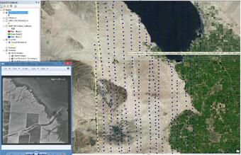
For this collection, an ArcGIS map file and geodatabase was set up with unique feature classes designated by vendor, year, and geographic area. Each photographic frame within the flight line was scanned at high quality, the center point of the image was digitized and located on digital NAIP imagery. The metadata is useful to CGS as an expedient method for locating relevant photographs for staff and other stakeholders. In addition, the metadata will be entered in the USGS-National Digital Catalog in an effort increase awareness of this collection.
One of our recent success that resulted from this study includes a California Geological Survey (CGS) effort from a recent wildfire in southern California. In response to a request from the City of Lake Elsinore, Riverside County, and the State of California Cal Fire representatives, CGS geologists were requested to perform evaluations of the burn area watershed, including noting Values-At-Risk (VARs), and alluvial fan areas. The CGS team requested access to the historical aerial photo records in the CGS Los Angeles Office to evaluate historical land use, evidence of previous debris flows, and landslides. For their evaluation, they also requested this selection of photos to be georeferenced. Because the photo center points were already digitized, the team had rapid access to relevant photo frames for their project, and georeferencing could be performed as a subset of the collection and placed onto a laptop or portable device for fieldwork.