
Authoritative Source: Parcel Viewer
Use a web-based parcel viewer in combination with other sources to research information about a structure.
What is a parcel viewer?
A web-based interactive tool that shows information about properties such as boundaries and ownership to aid in assessing their value, that can be used as a secondary authoritative source when researching structures.
Who provides a web-based parcel viewer?
County-level jurisdictions typically provide an online parcel viewer. To identify county information for a structure, you can turn on the boundaries layer in the map editor.
How do I know if a parcel viewer is available?
To find a parcel viewer via a web search, you might need to try various search terms. A good approach is to search by including the county name - ‘XX county assessor’s office’, ‘XX county parcel viewer’, ‘XX county GIS maps’, etc. You can also expand your geographic scope by searching outside of a county. Sometimes the state GIS/mapping departments can be helpful.
What data is found with a parcel viewer?
Parcel viewer data may consist of reports showing property lines, and land ownership information used for tax assessment. This information is sourced from county assessor databases.
A few valuable data layers for validating TNMCorps structures include:
- Physical address, especially city information (might be more granular)
- Roads layer (helpful with smaller back roads for example in cemetery validation)
- Oblique photos by capture date (handy for rural fire or EMS structures)
While authoritative, parcel data is considered a secondary source, as they are still aggregate sites much like NCES, since they aren't maintained or published directly by the features in question but can be used in conjunction with other authoritative sources. Thorough investigation and common sense must still be practiced when conducting research. You will find that parcel data information availability varies between jurisdictions.
Is access free?
Most don’t require registration and are free to access. However, you may find that a subscription account with username and password is required for additional GIS analysis features which is outside the scope of our use.
Example Applications
Example 1: Verifying a Fire Station
Let’s say you want to validate the location of Tripoli Fire Department, but Google Street ViewTM doesn’t provide coverage, or you can’t find information from an authoritative source.
Turn on the Boundaries layer to determine that the point is located in Bremer County, IA.
Media Sources/Usage: Public Domain. View Media Details
Confirm the physical address from the fire station’s website.
Media Sources/Usage: Public Domain. View Media Details
Search the web to determine that Bremer County, IA has a parcel viewer.
Media Sources/Usage: Public Domain. View Media Details
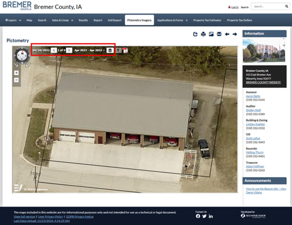
- Review the data and reference layer options to determine what can be useful. In the March 9, 2024, imagery, large doors are visible. While this legitimately may be a fire house, I still need to conduct more research, as this building style is used for many applications.

- Cycle through the available imagery. In the April 2022 imagery, the building has a few doors open. We can clearly see several fire trucks. You can confidently determine that this structure is a fire house while also moving the point to the correct location. Remember to validate that this structure is still operating as a fire station. When using any imagery, be sure to verify the date of the imagery capture; the more recent the capture date, the more reliable it is.
What is Oblique Imagery?
Oblique imagery is aerial imagery taken from low-flying aircraft at angle from 40-50 degrees. It’s extremely detailed because it’s focused on capturing property information for assessments.
You may see imagery referred to as ‘Pictometry’ (a trademarked service by Pictometry International Corp), or ‘CAMAvision’ (a trademarked service by Vanguard Appraisals, Inc.) to name a couple. This resource is useful when Google Street View™ provides no or low-quality coverage or you need to reference other imagery acquisition dates.
We don’t endorse the use of any specific commercial mapping service. Each may have different benefits, as well as limitations, depending on the situation and location. As always, commercial mapping services should only be used as a secondary resource to confirm information found on authoritative sources and the imagery in the editor.
Example 2: Verify a Cemetery
I recently utilized information from the Garland County, Arkansas Assessor’s office to determine that the address entered for Tranquil Cemetery was incorrect.

Turn on the Boundaries layer to determine that Tranquil Cemetery is in Garland County Arkansas.
Media Sources/Usage: Public Domain. View Media Details
- Search the web to find ‘Garland County parcel viewer’ or ‘Garland County assessor’s office’.
Browse the various data layers. I used the Garland County, Arkansas Assessor’s Real Property Records Search tool to search for Tranquil Cemetery by the original address entered in the address 1 field for the point. At other times, its best to limit the search by street name then pan the map to the point because the address number may be non-existent. That is something you’ll need to play around with.
Media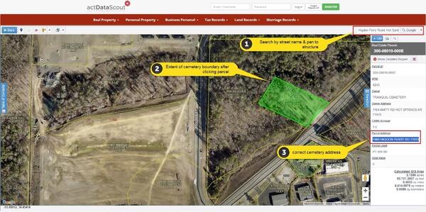 Sources/Usage: Public Domain. View Media Details
- Compare the data displayed in the parcel viewer with the address entered in the TNMCorps map editor, to determine that the address 1 field is incorrect. The correct address is ‘1960 Higdon Ferry Road 71913’. Make sure you are not entering the owner address which oftentimes is different than the address for the physical location of the structure.
Do I use the physical or mailing address?
If a structure has two different addresses posted on an authoritative source, one physical and one mailing, remember to enter the physical address. Although physical and mailing addresses are often the same, if you’re unsure, you can map the addresses to make sure they direct you to the physical location of the structure.
Note that USPS aggregates other city names under a ‘recommended’ city name for mail delivery purposes and assigns those cities to a specific zip code that is tied to a specific mail sorting facility for dispatch. And while you may find that county GIS information to be more granular that would be acceptable also. We appreciate thoroughness and attention to detail. We use the best available sources but sometimes information is unclear or conflicting, even from authoritative sources.