


Overhead blue green view of Theodore Roosevelt National Park from 3DEP Lidar derived DEM USGS_OPR_McKenzie_County_2014_QL2_Lidar
Are there any costs or restrictions to usage of data downloaded from The National Map?
Data from The National Map is free and in the public domain. There are no restrictions on downloaded data; however, we request that the following statement be used when citing, copying, or reprinting data: "Data available from U.S. Geological Survey, National Geospatial Program."
Learn more: USGS Copyrights and Credits Statement
Related
How can I download vector data from The National Map in bulk?
The USGS only offers vector downloads from The National Map in bulk by special request. For assistance, send an e-mail to tnm_help@usgs.gov and include your contact information, requested product, requested area, and download format.
Is there a user guide on how to download data using The National Map?
See the online National Map Viewer Quick Start Guide. For brief instructions, click on the "How to" link at the top of The National Map Downloader. Training videos are also available.
How do I download The National Map data products?
Download or access The National Map data products via several applications and websites: The National Map Download Client – The primary site for data downloads. See the training videos (lessons 4a-4d) or click the Help link at the top of the Downloader for detailed instructions. LidarExplorer – Lidar Point Cloud data only. See where lidar is available, get a list of downloadable products, and...
Why did I receive an "Error: Inventory request failure" message during a download request from The National Map?
The "Error: Inventory request failure" message occurs if our ScienceBase catalog database is not responding to download requests. To ensure data integrity, the ScienceBase catalog is shut down for nightly backup at 11:00 pm Mountain time, which takes 1-2 hours. If you find that the message is still occurring even after the allotted two hours, please contact The National Map Service Desk at tnm...
Are USGS reports/publications copyrighted?
USGS-authored or produced data and information are considered to be in the U.S. public domain and can be freely used without permission. All we ask is that you acknowledge the USGS as the source. While the content of most USGS webpages is in the U.S. public domain, not all information, illustrations, or photographs on our site are. Some non-USGS photographs, images, and/or graphics that appear on...
Are USGS topographic maps copyrighted?
All topographic maps produced by the U.S. Geological Survey (USGS) are in the public domain and are not copyrighted except for the following three cases that apply only to US Topo maps (produced 2009-present): Most maps in the period 2010-2016 contain commercially licensed road data (see note below). Orthoimages in Alaska are commercially licensed. Orthoimages in Hawaii were commercially licensed...
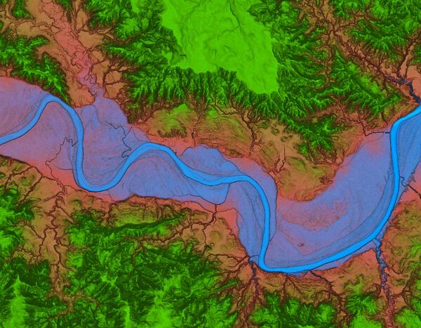
Theodore Roosevelt National Park 3DEP Lidar derived DEM Blue Green
Overhead blue green view of Theodore Roosevelt National Park from 3DEP Lidar derived DEM USGS_OPR_McKenzie_County_2014_QL2_Lidar

Lesson 4b - Downloading Maps and Data with The National Map Download Application
In this lesson we will provide a brief introduction on how to use The National Map Download Application to download USGS maps and data. The TNM Download Application allows users to explore and access the USGS staged products available for download.
In this lesson we will provide a brief introduction on how to use The National Map Download Application to download USGS maps and data. The TNM Download Application allows users to explore and access the USGS staged products available for download.

Lesson 4a – Using The National Map Download Application
In this lesson we will provide a brief introduction on how to use The National Map Download Application. The TNM Download application allows users to explore and access the USGS staged products available for download. This application is a user-friendly version of the USGS staged-product application programming interface, and it is available on most platforms.
In this lesson we will provide a brief introduction on how to use The National Map Download Application. The TNM Download application allows users to explore and access the USGS staged products available for download. This application is a user-friendly version of the USGS staged-product application programming interface, and it is available on most platforms.

USGS Announces NHDPlus HR National Release 1
The NHDPlus HR National presents a continuous representation of the most recent NHDPlus HR vector data for the contiguous United States, Puerto Rico, Hawaii, and parts of Alaska.
The NHDPlus HR National presents a continuous representation of the most recent NHDPlus HR vector data for the contiguous United States, Puerto Rico, Hawaii, and parts of Alaska.

Lesson 1: Introduction to Using The National Map Products and Services
Welcome to the USGS course on Using The National Map Products and Services. This series of videos is focused on The National Map and the variety of products and services that it provides.
Welcome to the USGS course on Using The National Map Products and Services. This series of videos is focused on The National Map and the variety of products and services that it provides.
Related
How can I download vector data from The National Map in bulk?
The USGS only offers vector downloads from The National Map in bulk by special request. For assistance, send an e-mail to tnm_help@usgs.gov and include your contact information, requested product, requested area, and download format.
Is there a user guide on how to download data using The National Map?
See the online National Map Viewer Quick Start Guide. For brief instructions, click on the "How to" link at the top of The National Map Downloader. Training videos are also available.
How do I download The National Map data products?
Download or access The National Map data products via several applications and websites: The National Map Download Client – The primary site for data downloads. See the training videos (lessons 4a-4d) or click the Help link at the top of the Downloader for detailed instructions. LidarExplorer – Lidar Point Cloud data only. See where lidar is available, get a list of downloadable products, and...
Why did I receive an "Error: Inventory request failure" message during a download request from The National Map?
The "Error: Inventory request failure" message occurs if our ScienceBase catalog database is not responding to download requests. To ensure data integrity, the ScienceBase catalog is shut down for nightly backup at 11:00 pm Mountain time, which takes 1-2 hours. If you find that the message is still occurring even after the allotted two hours, please contact The National Map Service Desk at tnm...
Are USGS reports/publications copyrighted?
USGS-authored or produced data and information are considered to be in the U.S. public domain and can be freely used without permission. All we ask is that you acknowledge the USGS as the source. While the content of most USGS webpages is in the U.S. public domain, not all information, illustrations, or photographs on our site are. Some non-USGS photographs, images, and/or graphics that appear on...
Are USGS topographic maps copyrighted?
All topographic maps produced by the U.S. Geological Survey (USGS) are in the public domain and are not copyrighted except for the following three cases that apply only to US Topo maps (produced 2009-present): Most maps in the period 2010-2016 contain commercially licensed road data (see note below). Orthoimages in Alaska are commercially licensed. Orthoimages in Hawaii were commercially licensed...
Theodore Roosevelt National Park 3DEP Lidar derived DEM Blue Green
Overhead blue green view of Theodore Roosevelt National Park from 3DEP Lidar derived DEM USGS_OPR_McKenzie_County_2014_QL2_Lidar
Overhead blue green view of Theodore Roosevelt National Park from 3DEP Lidar derived DEM USGS_OPR_McKenzie_County_2014_QL2_Lidar
Lesson 4b - Downloading Maps and Data with The National Map Download Application
In this lesson we will provide a brief introduction on how to use The National Map Download Application to download USGS maps and data. The TNM Download Application allows users to explore and access the USGS staged products available for download.
In this lesson we will provide a brief introduction on how to use The National Map Download Application to download USGS maps and data. The TNM Download Application allows users to explore and access the USGS staged products available for download.
Lesson 4a – Using The National Map Download Application
In this lesson we will provide a brief introduction on how to use The National Map Download Application. The TNM Download application allows users to explore and access the USGS staged products available for download. This application is a user-friendly version of the USGS staged-product application programming interface, and it is available on most platforms.
In this lesson we will provide a brief introduction on how to use The National Map Download Application. The TNM Download application allows users to explore and access the USGS staged products available for download. This application is a user-friendly version of the USGS staged-product application programming interface, and it is available on most platforms.
USGS Announces NHDPlus HR National Release 1
The NHDPlus HR National presents a continuous representation of the most recent NHDPlus HR vector data for the contiguous United States, Puerto Rico, Hawaii, and parts of Alaska.
The NHDPlus HR National presents a continuous representation of the most recent NHDPlus HR vector data for the contiguous United States, Puerto Rico, Hawaii, and parts of Alaska.
Lesson 1: Introduction to Using The National Map Products and Services
Welcome to the USGS course on Using The National Map Products and Services. This series of videos is focused on The National Map and the variety of products and services that it provides.
Welcome to the USGS course on Using The National Map Products and Services. This series of videos is focused on The National Map and the variety of products and services that it provides.
Updated Date: February 10, 2025