


The seismogram tracks 24 hours of signals at station WRM, just west of Halemaʻumaʻu crater at the summit of Kīlauea. Examples of spectrographic helicopter noise, a small VT event, and a larger VT event are given below the seismogram.
How are earthquakes recorded? How are earthquakes measured? How is the magnitude of an earthquake determined?
Earthquakes are recorded by a seismographic network. Each seismic station in the network measures the movement of the ground at that site. The slip of one block of rock over another in an earthquake releases energy that makes the ground vibrate. That vibration pushes the adjoining piece of ground and causes it to vibrate, and thus the energy travels out from the earthquake hypocenter in a wave.
There are many different ways to measure different aspects of an earthquake:
- Magnitude is the most common measure of an earthquake's size. It is a measure of the size of the earthquake source and is the same number no matter where you are or what the shaking feels like. The Richter scale is an outdated method for measuring magnitude that is no longer used by the USGS for large, teleseismic earthquakes. The Richter scale measures the largest wiggle (amplitude) on the recording, but other magnitude scales measure different parts of the earthquake. The USGS currently reports earthquake magnitudes using the Moment Magnitude scale, though many other magnitudes are calculated for research and comparison purposes.
- Intensity is a measure of the shaking and damage caused by the earthquake; this value changes from location to location.
Learn more:
Related
What is the difference between earthquake magnitude and earthquake intensity? What is the Modified Mercalli Intensity Scale?
Magnitude scales, like the moment magnitude, measure the size of the earthquake at its source. An earthquake has one magnitude. The magnitude does not depend on where the measurement is made. Often, several slightly different magnitudes are reported for an earthquake. This happens because the relation between the seismic measurements and the magnitude is complex and different procedures will often...
Moment magnitude, Richter scale - what are the different magnitude scales, and why are there so many?
Earthquake size, as measured by the Richter Scale is a well known, but not well understood, concept. The idea of a logarithmic earthquake magnitude scale was first developed by Charles Richter in the 1930's for measuring the size of earthquakes occurring in southern California using relatively high-frequency data from nearby seismograph stations. This magnitude scale was referred to as ML, with...
How do you determine the magnitude for an earthquake that occurred prior to the creation of the magnitude scale?
For earthquakes that occurred between about 1890 (when modern seismographs came into use) and 1935 when Charles Richter developed the magnitude scale, people went back to the old records and compared the seismograms from those days with similar records for later earthquakes. For earthquakes prior to about 1890, magnitudes have been estimated by looking at the physical effects (such as amount of...
How do seismologists locate an earthquake?
When an earthquake occurs, one of the first questions is "where was it?" The location may tell us what fault it was on and where damage (if any) most likely occurred. Unfortunately, Earth is not transparent and we can't just see or photograph the earthquake disturbance like meteorologists can photograph clouds. When an earthquake occurs, it generates an expanding wavefront from the earthquake...
What was the duration of the earthquake? Why don't you report the duration of each earthquake? How does the duration affect the magnitude?
The duration of an earthquake is related to its magnitude but not in a perfectly strict sense. There are two ways to think about the duration of an earthquake. The first is the length of time it takes for the fault to rupture and the second is the length of time shaking is felt at any given point (e.g. when someone says "I felt it shake for 10 seconds" they are making a statement about the...
How can an earthquake have a negative magnitude?
Magnitude calculations are based on a logarithmic scale, so a ten-fold drop in amplitude decreases the magnitude by 1. If an amplitude of 20 millimetres as measured on a seismic signal corresponds to a magnitude 2 earthquake, then: 10 times less (2 millimetres) corresponds to a magnitude of 1; 100 times less (0.2 millimetres) corresponds to magnitude 0; 1000 times less (0.02 millimetres)...
What does it mean that the earthquake occurred at a depth of 0 km? How can an earthquake have a negative depth; that would mean it’s in the air. What is the geoid, and what does it have to do with earthquake depth?
An earthquake cannot physically occur at a depth of 0 km or -1km (above the surface of the earth). In order for an earthquake to occur, two blocks of crust must slip past one another, and it is impossible for this to happen at or above the surface of the earth. So why do we report that the earthquake occurred at a depth of 0 km or event as a negative depth sometimes? First of all, the depth of an...
Seismometers, seismographs, seismograms - what's the difference? How do they work?
A seismometer is the internal part of the seismograph, which may be a pendulum or a mass mounted on a spring; however, it is often used synonymously with "seismograph". Seismographs are instruments used to record the motion of the ground during an earthquake. They are installed in the ground throughout the world and operated as part of a seismographic network. The earliest "seismoscope" was...
How can I make my own seismometer?
It is relatively easy to acquire the necessary materials and build your own seismometer. The links here are to various sources with information on how to build a seismometer. They range from very simple and inexpensive to sophisticated and pricey. Model Seismograph - Classroom Demonstration Build your own Seismograph Station Build Your Own Seismograph Amateur Seismology Homebuilt Seismograph FAQ
What was the first instrument that actually recorded an earthquake?
The earliest seismoscope was invented by the Chinese philosopher Chang Heng in A.D. 132. This was a large urn on the outside of which were eight dragon heads facing the eight principal directions of the compass. Below each dragon head was a toad with its mouth opened toward the dragon. When an earthquake occurred, one or more of the eight dragon-mouths would release a ball into the open mouth of...
What is a Geoid? Why do we use it and where does its shape come from?
A geoid is the irregular-shaped “ball” that scientists use to more accurately calculate depths of earthquakes, or any other deep object beneath the earth’s surface. Currently, we use the “WGS84” version (World Geodetic System of 1984). If Earth were a perfect sphere, calculations of depth and distances would be easy because we know the equations for those calculations on a sphere. However, the...

24 hours of seismic signals at station WRM
The seismogram tracks 24 hours of signals at station WRM, just west of Halemaʻumaʻu crater at the summit of Kīlauea. Examples of spectrographic helicopter noise, a small VT event, and a larger VT event are given below the seismogram.

Seismometer installation in Ridgecrest, California
USGS scientists Nicholas van der Elst and Alan Yong installing a seismometer near the 2019 Ridgecrest earthquakes in southern California in order to record its aftershocks.
USGS scientists Nicholas van der Elst and Alan Yong installing a seismometer near the 2019 Ridgecrest earthquakes in southern California in order to record its aftershocks.

An Illustrated Guide to Reading a Seismogram
This video provides a tutorial for anyone interested in interpreting the seismic records on public webicorder displays.
This video provides a tutorial for anyone interested in interpreting the seismic records on public webicorder displays.

Seismogram signal examples from volcanic earthquakes
Seismogram signal examples from volcanic earthquakes: volcano tectonic (VT) Low Frequency (LF)/Deep Long-Period (DLP), hybrid (mix of VT and LF), very low frequency (VLF), and Tremor.
Seismogram signal examples from volcanic earthquakes: volcano tectonic (VT) Low Frequency (LF)/Deep Long-Period (DLP), hybrid (mix of VT and LF), very low frequency (VLF), and Tremor.
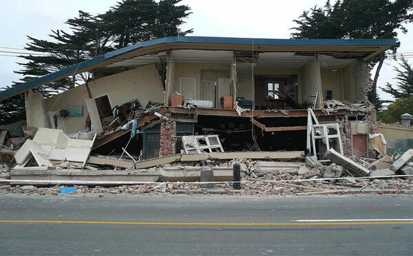
Earthquake-damaged building
Building damanged by the February 2011 earthquake in Christchurch, New Zealand.
Building damanged by the February 2011 earthquake in Christchurch, New Zealand.

Seismologists demonstrates how an earthquake's S and P waves travel...
Seismologists demonstrates how an earthquake's S and P waves travel through the earth at a CVO public open house.
Seismologists demonstrates how an earthquake's S and P waves travel through the earth at a CVO public open house.

Installing Antenna and Solar Panel for Seismic Station
With funding from the American Recovery and Reinvestment Act of 2009, The USGS Hawaiian Volcano Observatory recently upgraded its seismic monitoring network. Here, HVO staff, assisted by an HVO volunteer, installs the solar panel and antenna for one of the upgraded seismic stations on Kīlauea.
With funding from the American Recovery and Reinvestment Act of 2009, The USGS Hawaiian Volcano Observatory recently upgraded its seismic monitoring network. Here, HVO staff, assisted by an HVO volunteer, installs the solar panel and antenna for one of the upgraded seismic stations on Kīlauea.

A map of ShakeOut scenario shaking in southern California
A map of ShakeOut scenario shaking in southern California.
A map of ShakeOut scenario shaking in southern California.

When is an Earthquake not an Earthquake?
We sit down with USGS Senior Science Advisor for Earthquakes and Geologic Hazards David Applegate to talk about some of the subtle nuances and uses of seismic networks.
We sit down with USGS Senior Science Advisor for Earthquakes and Geologic Hazards David Applegate to talk about some of the subtle nuances and uses of seismic networks.
Related
What is the difference between earthquake magnitude and earthquake intensity? What is the Modified Mercalli Intensity Scale?
Magnitude scales, like the moment magnitude, measure the size of the earthquake at its source. An earthquake has one magnitude. The magnitude does not depend on where the measurement is made. Often, several slightly different magnitudes are reported for an earthquake. This happens because the relation between the seismic measurements and the magnitude is complex and different procedures will often...
Moment magnitude, Richter scale - what are the different magnitude scales, and why are there so many?
Earthquake size, as measured by the Richter Scale is a well known, but not well understood, concept. The idea of a logarithmic earthquake magnitude scale was first developed by Charles Richter in the 1930's for measuring the size of earthquakes occurring in southern California using relatively high-frequency data from nearby seismograph stations. This magnitude scale was referred to as ML, with...
How do you determine the magnitude for an earthquake that occurred prior to the creation of the magnitude scale?
For earthquakes that occurred between about 1890 (when modern seismographs came into use) and 1935 when Charles Richter developed the magnitude scale, people went back to the old records and compared the seismograms from those days with similar records for later earthquakes. For earthquakes prior to about 1890, magnitudes have been estimated by looking at the physical effects (such as amount of...
How do seismologists locate an earthquake?
When an earthquake occurs, one of the first questions is "where was it?" The location may tell us what fault it was on and where damage (if any) most likely occurred. Unfortunately, Earth is not transparent and we can't just see or photograph the earthquake disturbance like meteorologists can photograph clouds. When an earthquake occurs, it generates an expanding wavefront from the earthquake...
What was the duration of the earthquake? Why don't you report the duration of each earthquake? How does the duration affect the magnitude?
The duration of an earthquake is related to its magnitude but not in a perfectly strict sense. There are two ways to think about the duration of an earthquake. The first is the length of time it takes for the fault to rupture and the second is the length of time shaking is felt at any given point (e.g. when someone says "I felt it shake for 10 seconds" they are making a statement about the...
How can an earthquake have a negative magnitude?
Magnitude calculations are based on a logarithmic scale, so a ten-fold drop in amplitude decreases the magnitude by 1. If an amplitude of 20 millimetres as measured on a seismic signal corresponds to a magnitude 2 earthquake, then: 10 times less (2 millimetres) corresponds to a magnitude of 1; 100 times less (0.2 millimetres) corresponds to magnitude 0; 1000 times less (0.02 millimetres)...
What does it mean that the earthquake occurred at a depth of 0 km? How can an earthquake have a negative depth; that would mean it’s in the air. What is the geoid, and what does it have to do with earthquake depth?
An earthquake cannot physically occur at a depth of 0 km or -1km (above the surface of the earth). In order for an earthquake to occur, two blocks of crust must slip past one another, and it is impossible for this to happen at or above the surface of the earth. So why do we report that the earthquake occurred at a depth of 0 km or event as a negative depth sometimes? First of all, the depth of an...
Seismometers, seismographs, seismograms - what's the difference? How do they work?
A seismometer is the internal part of the seismograph, which may be a pendulum or a mass mounted on a spring; however, it is often used synonymously with "seismograph". Seismographs are instruments used to record the motion of the ground during an earthquake. They are installed in the ground throughout the world and operated as part of a seismographic network. The earliest "seismoscope" was...
How can I make my own seismometer?
It is relatively easy to acquire the necessary materials and build your own seismometer. The links here are to various sources with information on how to build a seismometer. They range from very simple and inexpensive to sophisticated and pricey. Model Seismograph - Classroom Demonstration Build your own Seismograph Station Build Your Own Seismograph Amateur Seismology Homebuilt Seismograph FAQ
What was the first instrument that actually recorded an earthquake?
The earliest seismoscope was invented by the Chinese philosopher Chang Heng in A.D. 132. This was a large urn on the outside of which were eight dragon heads facing the eight principal directions of the compass. Below each dragon head was a toad with its mouth opened toward the dragon. When an earthquake occurred, one or more of the eight dragon-mouths would release a ball into the open mouth of...
What is a Geoid? Why do we use it and where does its shape come from?
A geoid is the irregular-shaped “ball” that scientists use to more accurately calculate depths of earthquakes, or any other deep object beneath the earth’s surface. Currently, we use the “WGS84” version (World Geodetic System of 1984). If Earth were a perfect sphere, calculations of depth and distances would be easy because we know the equations for those calculations on a sphere. However, the...
24 hours of seismic signals at station WRM
The seismogram tracks 24 hours of signals at station WRM, just west of Halemaʻumaʻu crater at the summit of Kīlauea. Examples of spectrographic helicopter noise, a small VT event, and a larger VT event are given below the seismogram.
The seismogram tracks 24 hours of signals at station WRM, just west of Halemaʻumaʻu crater at the summit of Kīlauea. Examples of spectrographic helicopter noise, a small VT event, and a larger VT event are given below the seismogram.
Seismometer installation in Ridgecrest, California
USGS scientists Nicholas van der Elst and Alan Yong installing a seismometer near the 2019 Ridgecrest earthquakes in southern California in order to record its aftershocks.
USGS scientists Nicholas van der Elst and Alan Yong installing a seismometer near the 2019 Ridgecrest earthquakes in southern California in order to record its aftershocks.
An Illustrated Guide to Reading a Seismogram
This video provides a tutorial for anyone interested in interpreting the seismic records on public webicorder displays.
This video provides a tutorial for anyone interested in interpreting the seismic records on public webicorder displays.
Seismogram signal examples from volcanic earthquakes
Seismogram signal examples from volcanic earthquakes: volcano tectonic (VT) Low Frequency (LF)/Deep Long-Period (DLP), hybrid (mix of VT and LF), very low frequency (VLF), and Tremor.
Seismogram signal examples from volcanic earthquakes: volcano tectonic (VT) Low Frequency (LF)/Deep Long-Period (DLP), hybrid (mix of VT and LF), very low frequency (VLF), and Tremor.
Earthquake-damaged building
Building damanged by the February 2011 earthquake in Christchurch, New Zealand.
Building damanged by the February 2011 earthquake in Christchurch, New Zealand.
Seismologists demonstrates how an earthquake's S and P waves travel...
Seismologists demonstrates how an earthquake's S and P waves travel through the earth at a CVO public open house.
Seismologists demonstrates how an earthquake's S and P waves travel through the earth at a CVO public open house.
Installing Antenna and Solar Panel for Seismic Station
With funding from the American Recovery and Reinvestment Act of 2009, The USGS Hawaiian Volcano Observatory recently upgraded its seismic monitoring network. Here, HVO staff, assisted by an HVO volunteer, installs the solar panel and antenna for one of the upgraded seismic stations on Kīlauea.
With funding from the American Recovery and Reinvestment Act of 2009, The USGS Hawaiian Volcano Observatory recently upgraded its seismic monitoring network. Here, HVO staff, assisted by an HVO volunteer, installs the solar panel and antenna for one of the upgraded seismic stations on Kīlauea.
A map of ShakeOut scenario shaking in southern California
A map of ShakeOut scenario shaking in southern California.
A map of ShakeOut scenario shaking in southern California.
When is an Earthquake not an Earthquake?
We sit down with USGS Senior Science Advisor for Earthquakes and Geologic Hazards David Applegate to talk about some of the subtle nuances and uses of seismic networks.
We sit down with USGS Senior Science Advisor for Earthquakes and Geologic Hazards David Applegate to talk about some of the subtle nuances and uses of seismic networks.
Updated Date: September 10, 2024