


During UAS (uncrewed aircraft systems) overflights on April 15, the north vent within Halemaʻumaʻu at the summit of Kīlauea was not emitting as much volcanic gas as its southern counterpart, and it did not glow as hot in thermal images.
What does the USGS do with the information, pictures, and video collected by uncrewed aircraft systems?
All data collected by USGS uncrewed aircraft systems are processed and used in support of mission-specific research objectives. The vast majority of the resource management and scientific data will be archived for long-term use and placed in the public domain.
Learn more: National Uncrewed Systems Office
Related
How does the USGS use uncrewed aircraft systems?
The USGS National Uncrewed Systems Office (UAS) and the Office of Aviation Services are leading the development and testing of UAS scientific and resource management technology across the Department of the Interior in coordination with the other bureaus. Department of the Interior UAS capabilities support a range of activities including scientific research, monitoring environmental conditions...
Why does the USGS use uncrewed aircraft systems?
Uncrewed aircraft systems (UAS) provide an affordable solution when the USGS needs "eyes in the sky" but doesn’t have the budget to maintain a fleet of aircraft or to obtain commercial imagery. The USGS relies on a variety of remotely sensed data. UAS can provide a range of remote sensing data types, from aerial images to hyperspectral or Synthetic Aperture Radar (SAR) data at resolutions down to...
What types of uncrewed aircraft systems does the USGS use?
The Department of the Interior and USGS uncrewed aircraft systems (UAS) operational strategy emphasizes small systems with a combined aircraft and payload weight of less than 55 pounds. These small UAS are designed to support short (90 minute) missions and operate on rechargeable batteries or gasoline. This strategy recognizes that any given small UAS model will have a limited life span based on...
What restrictions are in place to protect citizens' civil liberties and privacy concerns related to uncrewed aircraft systems?
The USGS is a bureau within the Department of the Interior (DOI), which requires the following actions related to privacy: Operating uncrewed aircraft systems (UAS) primarily over DOI lands. Obtaining written permission from landowners when UAS operations need to launch and/or land on their property. Following standard Federal Aviation Administration (FAA) and DOI-approved procedures for aircraft...
What training do pilots of USGS uncrewed aircraft systems receive?
Training for USGS uncrewed aircraft system (UAS) operators is provided by the Department of the Interior Office of Aviation Services. The training has been approved by the Federal Aviation Administration and is specific to the types of UAS that the department operates. The training provides operators with the skills and knowledge necessary to operate a small UAS in the National Airspace System.
Does the USGS need flight approval to operate uncrewed aircraft systems?
Yes, approval is required for operating uncrewed aircraft systems (UAS). The USGS receives flight approval from the Federal Aviation Administration prior to every UAS mission. The official document is referred to as a Certificate of Authorization and Waiver. It is the approval process by which the Federal Aviation Administration allows for public agencies to operate UAS in the National Airspace...
Will I be able to see my house in an aerial photograph? Will enlarging the image let me see more detail?
The ability to see specific items in an aerial image is mostly a function of scale and resolution. The following aerial photography products all have a resolution of 1 meter or better, so you should be able to see an object the size of a house: High Resolution Orthoimagery (HRO) National Agriculture Imagery Program (NAIP) imagery Digital Orthophoto Quadrangle (DOQ) Use EarthExplorer to search for...
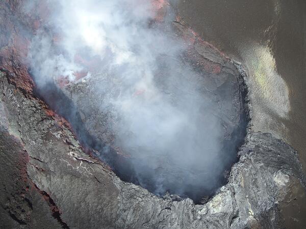
April 15, 2025 — UAS view into north vent
During UAS (uncrewed aircraft systems) overflights on April 15, the north vent within Halemaʻumaʻu at the summit of Kīlauea was not emitting as much volcanic gas as its southern counterpart, and it did not glow as hot in thermal images.

UAS Pilot Jennifer Cramer attaches a YellowScan Mapper+ lidar sensor to the underside of a DJI M600 in preparation to map the beach and marsh
linkUAS Pilot Jennifer Cramer attaches a YellowScan Mapper+ lidar sensor to the underside of a DJI M600 in preparation to map the beach and marsh.
Town Neck Beach, Sandwich, Massachusetts
Fall 2024 Photo Contest Winner: Jin-Si Over, People category

NUSO remote pilot setting up the Yellowscan Mapper+ on a UAS for flights at Palo Alto Battlefield National Historic Park.
linkMatt Burgess (NUSO) setting up the Yellowscan Mapper+ on a DJI M600 for flights at Palo Alto Battlefield National Historic Park.
NUSO remote pilot setting up the Yellowscan Mapper+ on a UAS for flights at Palo Alto Battlefield National Historic Park.
linkMatt Burgess (NUSO) setting up the Yellowscan Mapper+ on a DJI M600 for flights at Palo Alto Battlefield National Historic Park.

USGS Tests Prototype Ground Penetrating Radar Drone
The USGS, in cooperative research and development with GuidelineGEO, tested an 80 GHz self contained ground penetrating radar unit on a DJI Matrice 600 hexcopter (left). This platform was tested for flight performance and for measurement of river channel cross-sectional area as well as river water depth and river width.
The USGS, in cooperative research and development with GuidelineGEO, tested an 80 GHz self contained ground penetrating radar unit on a DJI Matrice 600 hexcopter (left). This platform was tested for flight performance and for measurement of river channel cross-sectional area as well as river water depth and river width.

Testing New Drone Technology to Measure Floodwaters
A USGS crew used new drone technology to test and evaluate new technology to measure water speed from the air without touching the water. This drone footage was taken on the Missouri River at Hermann, Missouri on March 27, 2019. Scientists compared these new method results to the conventional way of taking measurements from a boat.
A USGS crew used new drone technology to test and evaluate new technology to measure water speed from the air without touching the water. This drone footage was taken on the Missouri River at Hermann, Missouri on March 27, 2019. Scientists compared these new method results to the conventional way of taking measurements from a boat.
")
Hovering Above—UAS’ Role in the 2018 Kīlauea Volcano Eruption (AD)
The 2018 Kīlauea Volcano eruption marked the first time the federal government used Unmanned Aircraft Systems (UAS) to assist in an eruption response in the United States.
The 2018 Kīlauea Volcano eruption marked the first time the federal government used Unmanned Aircraft Systems (UAS) to assist in an eruption response in the United States.

Drone Footage of Whiskeytown National Recreation Area after Carr Fire
Drone footage of Whiskeytown National Recreation area in Northern California in October 2018, captured by drone pilot and USGS WERC ecologist Chase Freeman.
Drone footage of Whiskeytown National Recreation area in Northern California in October 2018, captured by drone pilot and USGS WERC ecologist Chase Freeman.

Kīlauea Volcano — Drone Over Lava Channel
USGS Mavic Pro drone image of the fissure 8 lava channel looking toward the vent. Overflows can be seen as incandescent spots beyond the channel margins. Drone flights and resultant imagery help scientists better identify areas of channel overflows and active flow advancement.
USGS Mavic Pro drone image of the fissure 8 lava channel looking toward the vent. Overflows can be seen as incandescent spots beyond the channel margins. Drone flights and resultant imagery help scientists better identify areas of channel overflows and active flow advancement.

3DR Solo quadcopter collecting imagery
A 3DR Solo quadcopter is collecting imagery at Chimney Bluffs State Park in NY. Using photogrammetric techniques, a 3D surface model was created providing elevation data.
A 3DR Solo quadcopter is collecting imagery at Chimney Bluffs State Park in NY. Using photogrammetric techniques, a 3D surface model was created providing elevation data.

The 3DR Solo with GoPro Hero4 camera and gimbal
The 3DR Solo with GoPro Hero4 camera and gimbal. Coming to a beach near you soon.
The 3DR Solo with GoPro Hero4 camera and gimbal. Coming to a beach near you soon.
")
Prescribed Burn — Tall Timbers Research Station, FL (Footage of Drone)
See the actual drone footage at: https://www.usgs.gov/media/videos/prescribed-burn-tall-timbers-research…
Footage of drone during a prescribed fire at Tall Timbers Research Station, Tallahassee, Florida (April 19, 2017).
See the actual drone footage at: https://www.usgs.gov/media/videos/prescribed-burn-tall-timbers-research…
Footage of drone during a prescribed fire at Tall Timbers Research Station, Tallahassee, Florida (April 19, 2017).

Drone Survey
USGS revolutionizes data collection by surveying a river channel within the Redlands area using a drone.
USGS revolutionizes data collection by surveying a river channel within the Redlands area using a drone.
Related
How does the USGS use uncrewed aircraft systems?
The USGS National Uncrewed Systems Office (UAS) and the Office of Aviation Services are leading the development and testing of UAS scientific and resource management technology across the Department of the Interior in coordination with the other bureaus. Department of the Interior UAS capabilities support a range of activities including scientific research, monitoring environmental conditions...
Why does the USGS use uncrewed aircraft systems?
Uncrewed aircraft systems (UAS) provide an affordable solution when the USGS needs "eyes in the sky" but doesn’t have the budget to maintain a fleet of aircraft or to obtain commercial imagery. The USGS relies on a variety of remotely sensed data. UAS can provide a range of remote sensing data types, from aerial images to hyperspectral or Synthetic Aperture Radar (SAR) data at resolutions down to...
What types of uncrewed aircraft systems does the USGS use?
The Department of the Interior and USGS uncrewed aircraft systems (UAS) operational strategy emphasizes small systems with a combined aircraft and payload weight of less than 55 pounds. These small UAS are designed to support short (90 minute) missions and operate on rechargeable batteries or gasoline. This strategy recognizes that any given small UAS model will have a limited life span based on...
What restrictions are in place to protect citizens' civil liberties and privacy concerns related to uncrewed aircraft systems?
The USGS is a bureau within the Department of the Interior (DOI), which requires the following actions related to privacy: Operating uncrewed aircraft systems (UAS) primarily over DOI lands. Obtaining written permission from landowners when UAS operations need to launch and/or land on their property. Following standard Federal Aviation Administration (FAA) and DOI-approved procedures for aircraft...
What training do pilots of USGS uncrewed aircraft systems receive?
Training for USGS uncrewed aircraft system (UAS) operators is provided by the Department of the Interior Office of Aviation Services. The training has been approved by the Federal Aviation Administration and is specific to the types of UAS that the department operates. The training provides operators with the skills and knowledge necessary to operate a small UAS in the National Airspace System.
Does the USGS need flight approval to operate uncrewed aircraft systems?
Yes, approval is required for operating uncrewed aircraft systems (UAS). The USGS receives flight approval from the Federal Aviation Administration prior to every UAS mission. The official document is referred to as a Certificate of Authorization and Waiver. It is the approval process by which the Federal Aviation Administration allows for public agencies to operate UAS in the National Airspace...
Will I be able to see my house in an aerial photograph? Will enlarging the image let me see more detail?
The ability to see specific items in an aerial image is mostly a function of scale and resolution. The following aerial photography products all have a resolution of 1 meter or better, so you should be able to see an object the size of a house: High Resolution Orthoimagery (HRO) National Agriculture Imagery Program (NAIP) imagery Digital Orthophoto Quadrangle (DOQ) Use EarthExplorer to search for...
April 15, 2025 — UAS view into north vent
During UAS (uncrewed aircraft systems) overflights on April 15, the north vent within Halemaʻumaʻu at the summit of Kīlauea was not emitting as much volcanic gas as its southern counterpart, and it did not glow as hot in thermal images.
During UAS (uncrewed aircraft systems) overflights on April 15, the north vent within Halemaʻumaʻu at the summit of Kīlauea was not emitting as much volcanic gas as its southern counterpart, and it did not glow as hot in thermal images.
UAS Pilot Jennifer Cramer attaches a YellowScan Mapper+ lidar sensor to the underside of a DJI M600 in preparation to map the beach and marsh
linkUAS Pilot Jennifer Cramer attaches a YellowScan Mapper+ lidar sensor to the underside of a DJI M600 in preparation to map the beach and marsh.
Town Neck Beach, Sandwich, Massachusetts
Fall 2024 Photo Contest Winner: Jin-Si Over, People category
NUSO remote pilot setting up the Yellowscan Mapper+ on a UAS for flights at Palo Alto Battlefield National Historic Park.
linkMatt Burgess (NUSO) setting up the Yellowscan Mapper+ on a DJI M600 for flights at Palo Alto Battlefield National Historic Park.
NUSO remote pilot setting up the Yellowscan Mapper+ on a UAS for flights at Palo Alto Battlefield National Historic Park.
linkMatt Burgess (NUSO) setting up the Yellowscan Mapper+ on a DJI M600 for flights at Palo Alto Battlefield National Historic Park.
USGS Tests Prototype Ground Penetrating Radar Drone
The USGS, in cooperative research and development with GuidelineGEO, tested an 80 GHz self contained ground penetrating radar unit on a DJI Matrice 600 hexcopter (left). This platform was tested for flight performance and for measurement of river channel cross-sectional area as well as river water depth and river width.
The USGS, in cooperative research and development with GuidelineGEO, tested an 80 GHz self contained ground penetrating radar unit on a DJI Matrice 600 hexcopter (left). This platform was tested for flight performance and for measurement of river channel cross-sectional area as well as river water depth and river width.
Testing New Drone Technology to Measure Floodwaters
A USGS crew used new drone technology to test and evaluate new technology to measure water speed from the air without touching the water. This drone footage was taken on the Missouri River at Hermann, Missouri on March 27, 2019. Scientists compared these new method results to the conventional way of taking measurements from a boat.
A USGS crew used new drone technology to test and evaluate new technology to measure water speed from the air without touching the water. This drone footage was taken on the Missouri River at Hermann, Missouri on March 27, 2019. Scientists compared these new method results to the conventional way of taking measurements from a boat.
Hovering Above—UAS’ Role in the 2018 Kīlauea Volcano Eruption (AD)
The 2018 Kīlauea Volcano eruption marked the first time the federal government used Unmanned Aircraft Systems (UAS) to assist in an eruption response in the United States.
The 2018 Kīlauea Volcano eruption marked the first time the federal government used Unmanned Aircraft Systems (UAS) to assist in an eruption response in the United States.
Drone Footage of Whiskeytown National Recreation Area after Carr Fire
Drone footage of Whiskeytown National Recreation area in Northern California in October 2018, captured by drone pilot and USGS WERC ecologist Chase Freeman.
Drone footage of Whiskeytown National Recreation area in Northern California in October 2018, captured by drone pilot and USGS WERC ecologist Chase Freeman.
Kīlauea Volcano — Drone Over Lava Channel
USGS Mavic Pro drone image of the fissure 8 lava channel looking toward the vent. Overflows can be seen as incandescent spots beyond the channel margins. Drone flights and resultant imagery help scientists better identify areas of channel overflows and active flow advancement.
USGS Mavic Pro drone image of the fissure 8 lava channel looking toward the vent. Overflows can be seen as incandescent spots beyond the channel margins. Drone flights and resultant imagery help scientists better identify areas of channel overflows and active flow advancement.
3DR Solo quadcopter collecting imagery
A 3DR Solo quadcopter is collecting imagery at Chimney Bluffs State Park in NY. Using photogrammetric techniques, a 3D surface model was created providing elevation data.
A 3DR Solo quadcopter is collecting imagery at Chimney Bluffs State Park in NY. Using photogrammetric techniques, a 3D surface model was created providing elevation data.
The 3DR Solo with GoPro Hero4 camera and gimbal
The 3DR Solo with GoPro Hero4 camera and gimbal. Coming to a beach near you soon.
The 3DR Solo with GoPro Hero4 camera and gimbal. Coming to a beach near you soon.
Prescribed Burn — Tall Timbers Research Station, FL (Footage of Drone)
See the actual drone footage at: https://www.usgs.gov/media/videos/prescribed-burn-tall-timbers-research…
Footage of drone during a prescribed fire at Tall Timbers Research Station, Tallahassee, Florida (April 19, 2017).
See the actual drone footage at: https://www.usgs.gov/media/videos/prescribed-burn-tall-timbers-research…
Footage of drone during a prescribed fire at Tall Timbers Research Station, Tallahassee, Florida (April 19, 2017).
Drone Survey
USGS revolutionizes data collection by surveying a river channel within the Redlands area using a drone.
USGS revolutionizes data collection by surveying a river channel within the Redlands area using a drone.
Updated Date: April 18, 2025