


A conceptual diagram of how groundwater storage and flow paths contribute to streamflow. Three key processes are illustrated: the process of infiltration (groundwater recharge), groundwater discharge along faster and slower flow paths to a stream, and variations in groundwater storage in response to wetter years and drought.
What is the Ground Water Atlas of the United States?
This Ground Water Atlas of the United States is a series of USGS publications that describe the location, the extent, and the geologic and hydrologic characteristics of the important aquifers of the Nation. The series consists of 13 chapters that describe the regional groundwater resources that collectively cover 50 States, Puerto Rico, and the U.S. Virgin Islands.
Learn more:
Related
What is the difference between a confined and an unconfined (water table) aquifer?
A confined aquifer is an aquifer below the land surface that is saturated with water. Layers of impermeable material are both above and below the aquifer, causing it to be under pressure so that when the aquifer is penetrated by a well, the water will rise above the top of the aquifer. A water table--or unconfined--aquifer is an aquifer whose upper water surface (water table) is at atmospheric...
How important is groundwater?
Groundwater, which is in aquifers below the surface of the Earth, is one of the Nation's most important natural resources. Groundwater is the source of about 37 percent of the water that county and city water departments supply to households and businesses (public supply). It provides drinking water for more than 90 percent of the rural population who do not get their water delivered to them from...
What is groundwater?
Groundwater is water that exists underground in saturated zones beneath the land surface. The upper surface of the saturated zone is called the water table. Contrary to popular belief, groundwater does not form underground rivers. It fills the pores and fractures in underground materials such as sand, gravel, and other rock, much the same way that water fills a sponge. If groundwater flows...
Where can I find detailed sampling methods for surface water and groundwater?
The National Field Manual for the Collection of Water-Quality Data (National Field Manual) provides guidelines and standard procedures for USGS personnel who collect data used to assess the quality of the Nation’s surface water and groundwater resources. The manual is published as separate chapters. Learn more: Techniques of Water-Resources Investigations Reports
If the ground filters water, is groundwater always clean?
Water drawn from a well was once precipitation that fell onto Earth's surface. It seeped into the ground and, over time, occupied the porous space in some subsurface material. Big particles that are in surface streams, such as leaf chunks, will not be seen in groundwater. So, yes, big particles are filtered out by the ground, along with some minerals and chemicals that are too small to see. But...

How groundwater contributes to streamflow
A conceptual diagram of how groundwater storage and flow paths contribute to streamflow. Three key processes are illustrated: the process of infiltration (groundwater recharge), groundwater discharge along faster and slower flow paths to a stream, and variations in groundwater storage in response to wetter years and drought.

Groundwater Response to Seismic Waves
Earthquakes can sometimes cause rapid changes in water levels. As seismic waves travel through rock formations, they can squeeze and stretch the rocks. This deformation can cause groundwater levels in aquifers to rise and fall, and it can rapidly force water in and out of nearby wells.
Earthquakes can sometimes cause rapid changes in water levels. As seismic waves travel through rock formations, they can squeeze and stretch the rocks. This deformation can cause groundwater levels in aquifers to rise and fall, and it can rapidly force water in and out of nearby wells.

Performing Aquifer Test During Borehole Drilling, Perigo Mine, Colorado
USGS scientists performing a step-injection aquifer test while drilling a bedrock borehole at the Perigo Mine site, Colorado during September 2023.
USGS scientists performing a step-injection aquifer test while drilling a bedrock borehole at the Perigo Mine site, Colorado during September 2023.

Pesticides in groundwater can eventually contaminate well water.
Chemicals can take a long time to appear in groundwater
Chemicals can take a long time to appear in groundwater

Groundwater site inspection, Petersham, Massachusetts
Shown in this photo is Hydrologic Technician Sam Banas performing an electric tape down measurement of a groundwater well. The site ID is: 422906072124301 MA-PHW 16 Petersham, MA
Shown in this photo is Hydrologic Technician Sam Banas performing an electric tape down measurement of a groundwater well. The site ID is: 422906072124301 MA-PHW 16 Petersham, MA
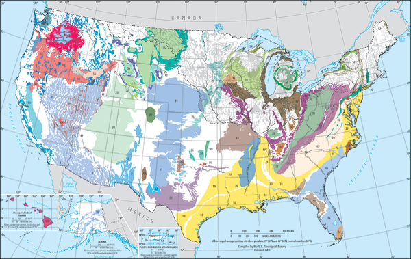
Principal Aquifers of the United States
Two-dimensional map representation of the principal aquifers of the United States.
Two-dimensional map representation of the principal aquifers of the United States.

PubTalk 9/2011 — Tracking the Nation's Groundwater Reserves
--issues facing current and future water supplies
by William Alley, USGS Office of Groundwater
--issues facing current and future water supplies
by William Alley, USGS Office of Groundwater

Aquifer Compaction
Fine-grained sediments (clays and silts) within an aquifer system are the main culprits in land subsidence due to groundwater pumping. Fine-grained sediments are special because they are composed of platy grains. When fine-grained sediments are originally deposited, they tend to be deposited in random orientations.
Fine-grained sediments (clays and silts) within an aquifer system are the main culprits in land subsidence due to groundwater pumping. Fine-grained sediments are special because they are composed of platy grains. When fine-grained sediments are originally deposited, they tend to be deposited in random orientations.

Areas at high risk of nitrogen contamination of groundwater
Modeling integrates information to estimate risks of nitrate contamination to shallow ground water
Modeling integrates information to estimate risks of nitrate contamination to shallow ground water
Related
What is the difference between a confined and an unconfined (water table) aquifer?
A confined aquifer is an aquifer below the land surface that is saturated with water. Layers of impermeable material are both above and below the aquifer, causing it to be under pressure so that when the aquifer is penetrated by a well, the water will rise above the top of the aquifer. A water table--or unconfined--aquifer is an aquifer whose upper water surface (water table) is at atmospheric...
How important is groundwater?
Groundwater, which is in aquifers below the surface of the Earth, is one of the Nation's most important natural resources. Groundwater is the source of about 37 percent of the water that county and city water departments supply to households and businesses (public supply). It provides drinking water for more than 90 percent of the rural population who do not get their water delivered to them from...
What is groundwater?
Groundwater is water that exists underground in saturated zones beneath the land surface. The upper surface of the saturated zone is called the water table. Contrary to popular belief, groundwater does not form underground rivers. It fills the pores and fractures in underground materials such as sand, gravel, and other rock, much the same way that water fills a sponge. If groundwater flows...
Where can I find detailed sampling methods for surface water and groundwater?
The National Field Manual for the Collection of Water-Quality Data (National Field Manual) provides guidelines and standard procedures for USGS personnel who collect data used to assess the quality of the Nation’s surface water and groundwater resources. The manual is published as separate chapters. Learn more: Techniques of Water-Resources Investigations Reports
If the ground filters water, is groundwater always clean?
Water drawn from a well was once precipitation that fell onto Earth's surface. It seeped into the ground and, over time, occupied the porous space in some subsurface material. Big particles that are in surface streams, such as leaf chunks, will not be seen in groundwater. So, yes, big particles are filtered out by the ground, along with some minerals and chemicals that are too small to see. But...
How groundwater contributes to streamflow
A conceptual diagram of how groundwater storage and flow paths contribute to streamflow. Three key processes are illustrated: the process of infiltration (groundwater recharge), groundwater discharge along faster and slower flow paths to a stream, and variations in groundwater storage in response to wetter years and drought.
A conceptual diagram of how groundwater storage and flow paths contribute to streamflow. Three key processes are illustrated: the process of infiltration (groundwater recharge), groundwater discharge along faster and slower flow paths to a stream, and variations in groundwater storage in response to wetter years and drought.
Groundwater Response to Seismic Waves
Earthquakes can sometimes cause rapid changes in water levels. As seismic waves travel through rock formations, they can squeeze and stretch the rocks. This deformation can cause groundwater levels in aquifers to rise and fall, and it can rapidly force water in and out of nearby wells.
Earthquakes can sometimes cause rapid changes in water levels. As seismic waves travel through rock formations, they can squeeze and stretch the rocks. This deformation can cause groundwater levels in aquifers to rise and fall, and it can rapidly force water in and out of nearby wells.
Performing Aquifer Test During Borehole Drilling, Perigo Mine, Colorado
USGS scientists performing a step-injection aquifer test while drilling a bedrock borehole at the Perigo Mine site, Colorado during September 2023.
USGS scientists performing a step-injection aquifer test while drilling a bedrock borehole at the Perigo Mine site, Colorado during September 2023.
Pesticides in groundwater can eventually contaminate well water.
Chemicals can take a long time to appear in groundwater
Chemicals can take a long time to appear in groundwater
Groundwater site inspection, Petersham, Massachusetts
Shown in this photo is Hydrologic Technician Sam Banas performing an electric tape down measurement of a groundwater well. The site ID is: 422906072124301 MA-PHW 16 Petersham, MA
Shown in this photo is Hydrologic Technician Sam Banas performing an electric tape down measurement of a groundwater well. The site ID is: 422906072124301 MA-PHW 16 Petersham, MA
Principal Aquifers of the United States
Two-dimensional map representation of the principal aquifers of the United States.
Two-dimensional map representation of the principal aquifers of the United States.
PubTalk 9/2011 — Tracking the Nation's Groundwater Reserves
--issues facing current and future water supplies
by William Alley, USGS Office of Groundwater
--issues facing current and future water supplies
by William Alley, USGS Office of Groundwater
Aquifer Compaction
Fine-grained sediments (clays and silts) within an aquifer system are the main culprits in land subsidence due to groundwater pumping. Fine-grained sediments are special because they are composed of platy grains. When fine-grained sediments are originally deposited, they tend to be deposited in random orientations.
Fine-grained sediments (clays and silts) within an aquifer system are the main culprits in land subsidence due to groundwater pumping. Fine-grained sediments are special because they are composed of platy grains. When fine-grained sediments are originally deposited, they tend to be deposited in random orientations.
Areas at high risk of nitrogen contamination of groundwater
Modeling integrates information to estimate risks of nitrate contamination to shallow ground water
Modeling integrates information to estimate risks of nitrate contamination to shallow ground water
Updated Date: March 20, 2025