


"1964 Quake: The Great Alaska Earthquake" is an eleven minute video highlighting the impacts and effects of America's largest recorded earthquake. It is an expanded version of the four minute video "Magnitude 9.2". Both were created as part of USGS activities acknowledging the fifty year anniversary of the quake on March 27, 2014.
Where can I find photographs of earthquake damage?
Two sources for photographs that show earthquake damage are:
-
U.S. Geological Survey Photographic Library (see 'earthquakes' in the categories left column)
Related
At what magnitude does damage begin to occur in an earthquake?
It isn't that simple. There is not one magnitude above which damage will occur. It depends on other variables, such as the distance from the earthquake, what type of soil you are on, building construction, etc. That being said, damage does not usually occur until the earthquake magnitude reaches somewhere above 4 or 5. Learn more: Glossary of earthquake terms Earthquake Magnitude, Energy Release...
What does an earthquake feel like?
The way an earthquake feels depends on where you are, where the earthquake is, and how big the earthquake is: A large earthquake nearby will feel like a sudden large jolt followed quickly by more strong shaking that may last a few seconds or up to a couple of minutes if it's a rare great event. The shaking will feel violent and it will be difficult to stand up. The contents of your house will be a...
What are those booms I sometimes hear before or during an earthquake?
"Booms" have been reported for a long time, and they tend to occur more in the Northeastern US and along the East Coast. Of course, most "booms" that people hear or experience are actually some type of cultural noise, such as some type of explosion, a large vehicle going by, or sometimes a sonic boom, but there have been many reports of "booms" that cannot be explained by man-made sources. No one...
Why do earthquakes in other countries seem to cause more damage and casualties than earthquakes in the U.S.?
There is more damage and more deaths from earthquakes in other parts of the world primarily because of buildings which are poorly designed and constructed for earthquake regions, and population density.
How does an earthquake affect groundwater levels and water quality in wells?
Groundwater levels in wells can oscillate up and down when seismic waves pass. The water level might remain higher or lower for a period of time after the seismic waves end, but sometimes a long-term offset of groundwater levels follows an earthquake. The largest recorded earthquake-induced offset in a well is a one meter rise. Water quality can also be affected by earthquakes, typically in...
What is liquefaction?
Liquefaction takes place when loosely packed, water-logged sediments at or near the ground surface lose their strength in response to strong ground shaking. Liquefaction occurring beneath buildings and other structures can cause major damage during earthquakes. For example, the 1964 Niigata earthquake caused widespread liquefaction in Niigata, Japan which destroyed many buildings. Also, during the...
Can you feel an earthquake if you're in a cave? Is it safer to be in a cave during an earthquake?
There is nothing different about a cave that would make it immune to the shaking from an earthquake. Just as there are safer and less safe places to be on the surface of the earth during an earthquake, there are also various characteristics inside caves that make some cave locations safer or less safe than others. First of all, whether or not you feel an earthquake in a cave depends chiefly upon...
What are earthquake lights?
Phenomena such as sheet lightning, balls of light, streamers, and steady glows, reported in association with earthquakes are called earthquake lights (EQL). Geophysicists differ on the extent to which they think that individual reports of unusual lighting near the time and epicenter of an earthquake actually represent EQL: some doubt that any of the reports constitute solid evidence for EQL...
How does the USGS tell the difference between an earthquake and a sonic boom?
Steps to identification of a sonic boom: The USGS sees either nothing on our seismic records or a fairly short high-frequency signal that doesn't look like an earthquake. On rare occasions, we see the event on multiple stations, and the time difference between stations matches the speed of sound in air, which is slower than the speed of seismic waves in rock. Felt reports come from a wide area...

1964 Quake: The Great Alaska Earthquake
"1964 Quake: The Great Alaska Earthquake" is an eleven minute video highlighting the impacts and effects of America's largest recorded earthquake. It is an expanded version of the four minute video "Magnitude 9.2". Both were created as part of USGS activities acknowledging the fifty year anniversary of the quake on March 27, 2014.
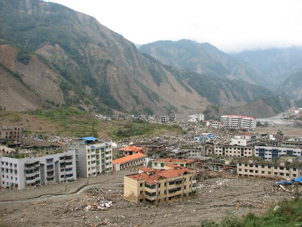
Damage from 2008 Great Sichuan Earthquake in China
The May 12, 2008, Great Sichuan Earthquake, also called the Wenchuan Earthquake, occurred at 14:28 local time, in Sichuan Province, China. The earthquake magnitudes were Mw = 7.9 (USGS), Ms = 8.0 (Chinese Earthquake Administration). The epicenter was 80 km west-northwest of Chengdu, the capital city of Sichuan province.
The May 12, 2008, Great Sichuan Earthquake, also called the Wenchuan Earthquake, occurred at 14:28 local time, in Sichuan Province, China. The earthquake magnitudes were Mw = 7.9 (USGS), Ms = 8.0 (Chinese Earthquake Administration). The epicenter was 80 km west-northwest of Chengdu, the capital city of Sichuan province.

Northridge, CA Earthquake Damage
Collection of USGS still images taken after the January 17, 1994 Northridge earthquake highlighting the damage to buildings and infrastructure.
Collection of USGS still images taken after the January 17, 1994 Northridge earthquake highlighting the damage to buildings and infrastructure.
Related
At what magnitude does damage begin to occur in an earthquake?
It isn't that simple. There is not one magnitude above which damage will occur. It depends on other variables, such as the distance from the earthquake, what type of soil you are on, building construction, etc. That being said, damage does not usually occur until the earthquake magnitude reaches somewhere above 4 or 5. Learn more: Glossary of earthquake terms Earthquake Magnitude, Energy Release...
What does an earthquake feel like?
The way an earthquake feels depends on where you are, where the earthquake is, and how big the earthquake is: A large earthquake nearby will feel like a sudden large jolt followed quickly by more strong shaking that may last a few seconds or up to a couple of minutes if it's a rare great event. The shaking will feel violent and it will be difficult to stand up. The contents of your house will be a...
What are those booms I sometimes hear before or during an earthquake?
"Booms" have been reported for a long time, and they tend to occur more in the Northeastern US and along the East Coast. Of course, most "booms" that people hear or experience are actually some type of cultural noise, such as some type of explosion, a large vehicle going by, or sometimes a sonic boom, but there have been many reports of "booms" that cannot be explained by man-made sources. No one...
Why do earthquakes in other countries seem to cause more damage and casualties than earthquakes in the U.S.?
There is more damage and more deaths from earthquakes in other parts of the world primarily because of buildings which are poorly designed and constructed for earthquake regions, and population density.
How does an earthquake affect groundwater levels and water quality in wells?
Groundwater levels in wells can oscillate up and down when seismic waves pass. The water level might remain higher or lower for a period of time after the seismic waves end, but sometimes a long-term offset of groundwater levels follows an earthquake. The largest recorded earthquake-induced offset in a well is a one meter rise. Water quality can also be affected by earthquakes, typically in...
What is liquefaction?
Liquefaction takes place when loosely packed, water-logged sediments at or near the ground surface lose their strength in response to strong ground shaking. Liquefaction occurring beneath buildings and other structures can cause major damage during earthquakes. For example, the 1964 Niigata earthquake caused widespread liquefaction in Niigata, Japan which destroyed many buildings. Also, during the...
Can you feel an earthquake if you're in a cave? Is it safer to be in a cave during an earthquake?
There is nothing different about a cave that would make it immune to the shaking from an earthquake. Just as there are safer and less safe places to be on the surface of the earth during an earthquake, there are also various characteristics inside caves that make some cave locations safer or less safe than others. First of all, whether or not you feel an earthquake in a cave depends chiefly upon...
What are earthquake lights?
Phenomena such as sheet lightning, balls of light, streamers, and steady glows, reported in association with earthquakes are called earthquake lights (EQL). Geophysicists differ on the extent to which they think that individual reports of unusual lighting near the time and epicenter of an earthquake actually represent EQL: some doubt that any of the reports constitute solid evidence for EQL...
How does the USGS tell the difference between an earthquake and a sonic boom?
Steps to identification of a sonic boom: The USGS sees either nothing on our seismic records or a fairly short high-frequency signal that doesn't look like an earthquake. On rare occasions, we see the event on multiple stations, and the time difference between stations matches the speed of sound in air, which is slower than the speed of seismic waves in rock. Felt reports come from a wide area...
1964 Quake: The Great Alaska Earthquake
"1964 Quake: The Great Alaska Earthquake" is an eleven minute video highlighting the impacts and effects of America's largest recorded earthquake. It is an expanded version of the four minute video "Magnitude 9.2". Both were created as part of USGS activities acknowledging the fifty year anniversary of the quake on March 27, 2014.
"1964 Quake: The Great Alaska Earthquake" is an eleven minute video highlighting the impacts and effects of America's largest recorded earthquake. It is an expanded version of the four minute video "Magnitude 9.2". Both were created as part of USGS activities acknowledging the fifty year anniversary of the quake on March 27, 2014.
Damage from 2008 Great Sichuan Earthquake in China
The May 12, 2008, Great Sichuan Earthquake, also called the Wenchuan Earthquake, occurred at 14:28 local time, in Sichuan Province, China. The earthquake magnitudes were Mw = 7.9 (USGS), Ms = 8.0 (Chinese Earthquake Administration). The epicenter was 80 km west-northwest of Chengdu, the capital city of Sichuan province.
The May 12, 2008, Great Sichuan Earthquake, also called the Wenchuan Earthquake, occurred at 14:28 local time, in Sichuan Province, China. The earthquake magnitudes were Mw = 7.9 (USGS), Ms = 8.0 (Chinese Earthquake Administration). The epicenter was 80 km west-northwest of Chengdu, the capital city of Sichuan province.
Northridge, CA Earthquake Damage
Collection of USGS still images taken after the January 17, 1994 Northridge earthquake highlighting the damage to buildings and infrastructure.
Collection of USGS still images taken after the January 17, 1994 Northridge earthquake highlighting the damage to buildings and infrastructure.
Updated Date: February 16, 2022