U.S. flag

An official website of the United States government

3D Hydrography Program

The implementation of 3D National Hydrography Program (3DHP) marks the start of a new era of water data - the first systematic remapping of the Nation’s hydrography since the original USGS 1:24,000-scale topographic mapping program was active. Community-wide coordinated investments will contribute toward a consistent set of national water data to answer the most demanding water resource questions.

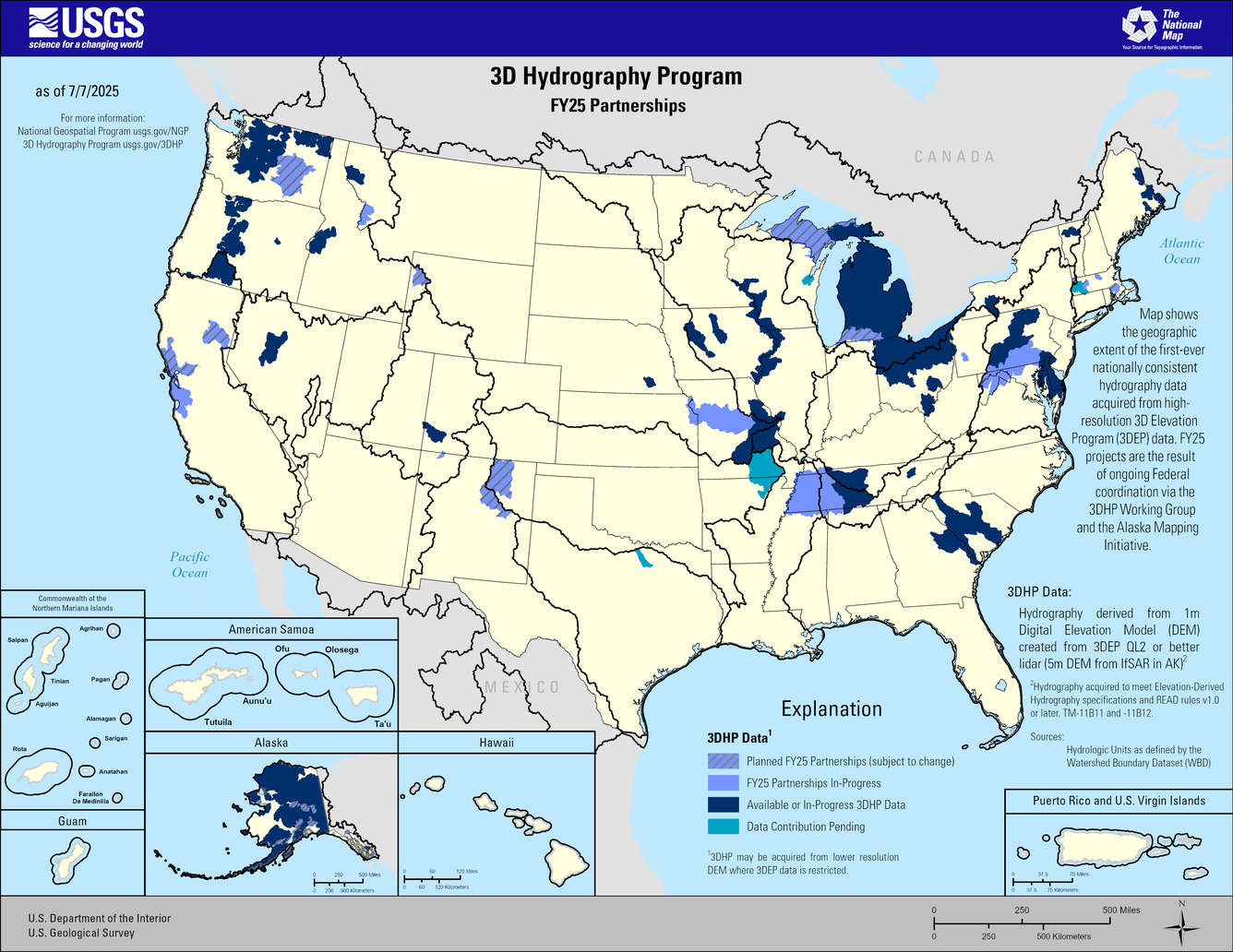
3D Hydrography Program FY24 Partnerships
This map of the United States and its territories shows geographic extent of the first-ever nationally consistent hydrography data acquired from high-resolution 3D Elevation Program (3DEP) data. FY24 projects are the result of ongoing Federal coordination via the 3DHP Working Group and the Alaska Mapping Initiative.
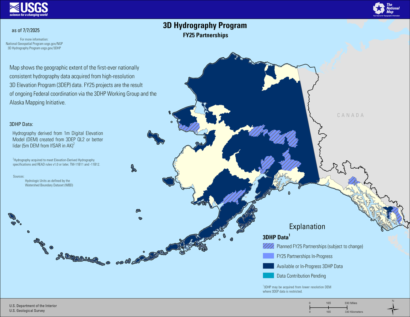
3D Hydrography Program FY24 Partnerships in Alaska
This map of Alaska shows geographic extent of the first-ever nationally consistent hydrography data acquired from high-resolution 3D Elevation Program (3DEP) data. FY24 projects are the result of ongoing Federal coordination via the 3DHP Working Group and the Alaska Mapping Initiative.
FY24 Status of 3DHP Quality Data
This map of the United States and its territories shows geographic extent of the first-ever nationally consistent hydrography data acquired from high-resolution 3D Elevation Program (3DEP) data. FY24 projects are the result of ongoing Federal coordination via the 3DHP Working Group and the Alaska Mapping Initiative.
FY24 Status of 3DHP Quality Data in Alaska
This map of Alasska shows geographic extent of the first-ever nationally consistent hydrography data acquired from high-resolution 3D Elevation Program (3DEP) data. FY24 projects are the result of ongoing Federal coordination via the 3DHP Working Group and the Alaska Mapping Initiative.


The 3DHP will significantly improve the level of detail, currency, and content of hydrography data by deriving (1) three-dimensional (3D) stream network datasets and watersheds from high-quality 3D Elevation Program (3DEP) data and (2) other elevation derivatives to support applications like hydrologic and hydraulic modeling (Figure 1). The 3DHP will improve the ability to track information related to water as it moves through the hydrologic cycle by connecting surface-water features traditionally represented in the National Hydrography Dataset (NHD) to data about wetlands, engineered hydrologic systems, and groundwater; it will also improve the attribution of important hydrologic characteristics like streamflow permanence. 

3DHP feature density and alignment compared to NHD
Figure 1: Graphic showing the improved alignment possible in the 3D Hydrography Program by deriving hydrography data from high-quality 3DEP elevation data. 

News

The National Map and the 3D Hydrography Program

The National Map and the 3D Hydrography Program

The 3D Hydrography Program at One Year

The 3D Hydrography Program at One Year

USGS announces elevation and hydrography data acquisition partnership opportunities for fiscal year 2025.

USGS announces elevation and hydrography data acquisition partnership opportunities for fiscal year 2025.

Publications

The 3D National Topography Model Call for Action—Part 1. The 3D Hydrography Program

The U.S. Geological Survey is initiating the 3D Hydrography Program (3DHP), the first systematic remapping of the Nation’s surface waters since the original 1:24,000-scale topographic mapping program was active from 1947 to 1992. Building on decades of experience maintaining the National Hydrography Dataset (NHD), the Watershed Boundary Dataset (WBD), and the NHDPlus High Resolution (NHDPlus HR),
Authors
Rebecca Anderson, Vicki Lukas, Stephen S. Aichele

Elevation-derived hydrography acquisition specifications

Hydrographic features derived from U.S. Geological Survey (USGS) 3D Elevation Program data, and collected for use by the USGS, must meet the specifications described in this document. The specifications described herein pertain to the final product delivered to the USGS, not to methods used to derive the hydrographic features. The specifications describe the collection area, spatial reference syst
Authors
Silvia Terziotti, Christy-Ann Archuleta

Elevation-derived hydrography—Representation, extraction, attribution, and delineation rules

With the increasing availability of 3D Elevation Program (3DEP) quality high resolution elevation data across the United States and the pressing need for better integrated elevation and hydrography data, the U.S. Geological Survey is developing guidance to improve the horizontal and vertical alignment of these datasets. The U.S. Geological Survey is providing the Elevation-Derived Hydrography—Acqu
Authors
Christy-Ann Archuleta, Silvia Terziotti
Was this page helpful?