
A gravel bar on the north fork of the Agashashok River, Alaska. This work is part of the Hydro-Ecology of Arctic Thawing (HEAT): Hydrology project that takes place in the Arctic Network Parks because they lie in a region that is rapidly warming.
Images
Browse images from a wide range of science topics covered by USGS. All items in this gallery are considered public domain unless otherwise noted.
Filter Total Items: 1458

Gravel bar on the north fork of the Agashashok River, Alaska
A gravel bar on the north fork of the Agashashok River, Alaska. This work is part of the Hydro-Ecology of Arctic Thawing (HEAT): Hydrology project that takes place in the Arctic Network Parks because they lie in a region that is rapidly warming.

Lindsay Carlson swabbing hunter harvested ducks in western Alaska
Lindsay Carlson swabbing hunter-harvested ducks in western Alaska as part of USGS research to investigate the persistence of avian influenza viruses in North American wetlands. USGS scientists and colleagues found that influenza A viruses may remain infectious in surface waters of northern wetlands for more than seven months.
Lindsay Carlson swabbing hunter-harvested ducks in western Alaska as part of USGS research to investigate the persistence of avian influenza viruses in North American wetlands. USGS scientists and colleagues found that influenza A viruses may remain infectious in surface waters of northern wetlands for more than seven months.

A misty morning in the headwaters of the Akillik River, Alaska
A misty morning in the headwaters of the Akillik River, Alaska. This work is part of the Hydro-Ecology of Arctic Thawing (HEAT): Hydrology project that takes place in the Arctic Network Parks because they lie in a region that is rapidly warming.
A misty morning in the headwaters of the Akillik River, Alaska. This work is part of the Hydro-Ecology of Arctic Thawing (HEAT): Hydrology project that takes place in the Arctic Network Parks because they lie in a region that is rapidly warming.

Skinny Common Murre flying with keel protruding
Skinny Common Murre with keel protruding. Lower Cook Inlet, Alaska
Skinny Common Murre with keel protruding. Lower Cook Inlet, Alaska

Twentymile River sonar on a bridge
Twentymile River sonar on a bridge

A Peregrine Falcon flies off with a Black-legged Kittiwake
A Peregrine Falcon flies off with a Black-legged Kittiwake from its colony at Gull Island, Alaska.
A Peregrine Falcon flies off with a Black-legged Kittiwake from its colony at Gull Island, Alaska.

Knik River sonar on a bridge
Knik River sonar on a bridge

Glaucous-winged Gull chick on Bogoslof Island in August 2018
A Glaucous-winged Gull on the rock floor of the Bogoslof Volcano a year after it explosively erupted.
A Glaucous-winged Gull on the rock floor of the Bogoslof Volcano a year after it explosively erupted.

Glaucous-winged Gull chick walking on Bogoslof Island in August 2018
A Glaucous-winged Gull on the rock floor of the Bogoslof Volcano a year after it explosively erupted.
A Glaucous-winged Gull on the rock floor of the Bogoslof Volcano a year after it explosively erupted.

Scientist standing on the pre-1900 riverbed
A scientist standing on the pre-1900 riverbed that is now 20 feet above the rapids at The Kink on the North Fork Fortymile River. The Kink resulted from human mining activity that diverted the river in 1900.
A scientist standing on the pre-1900 riverbed that is now 20 feet above the rapids at The Kink on the North Fork Fortymile River. The Kink resulted from human mining activity that diverted the river in 1900.

USGS scientist at The Kink, North Fork Fortymile River, Alaska
A USGS scientist standing on the pre-1900 riverbed that is now the rim of the bedrock canyon at The Kink on North Fork Fortymile River. The Kink resulted from human mining activity that diverted the river in 1900.
A USGS scientist standing on the pre-1900 riverbed that is now the rim of the bedrock canyon at The Kink on North Fork Fortymile River. The Kink resulted from human mining activity that diverted the river in 1900.

USGS scientist investigates bedrock canyon cut by a river
A scientist at The Kink on North Fork Fortymile River. He is standing next to gravel that was in the river in 1900 but is now on the rim of a 20-foot-deep bedrock canyon. The canyon formed as a result of human mining activity that diverted the river in 1900.
A scientist at The Kink on North Fork Fortymile River. He is standing next to gravel that was in the river in 1900 but is now on the rim of a 20-foot-deep bedrock canyon. The canyon formed as a result of human mining activity that diverted the river in 1900.

Scientist investigates bedrock canyon, North Fork Fortymile River, AK
A scientist investigates a bedrock canyon cut by the North Fork Fortymile River in response to human mining activity in 1900. The smooth grooves on the rock in the lower right corner were formed by river erosion in the last century.
A scientist investigates a bedrock canyon cut by the North Fork Fortymile River in response to human mining activity in 1900. The smooth grooves on the rock in the lower right corner were formed by river erosion in the last century.

Skinny Common Murre (in foreground) with keel protruding
Skinny Common Murre (in foreground) with keel protruding in lower Cook Inlet, Alaska.
Skinny Common Murre (in foreground) with keel protruding in lower Cook Inlet, Alaska.

Geologic mapping in remote interior Alaska
A USGS scientist is recording structural measurements collected from an outcrop of deformed and metamorphosed bedrock in the Yukon-Tanana upland of eastern interior Alaska. A team of two geologists were deployed by helicopter to conduct a geologic mapping and sampling traverse covering approximately 5 miles along the top of this ridge.
A USGS scientist is recording structural measurements collected from an outcrop of deformed and metamorphosed bedrock in the Yukon-Tanana upland of eastern interior Alaska. A team of two geologists were deployed by helicopter to conduct a geologic mapping and sampling traverse covering approximately 5 miles along the top of this ridge.

Scientists in kayaks next to floating limnocorral
Two scientists in kayaks next to a floating limnocorral on McKinley Lake, near Cordova, Alaska for Elodea spp. experiment. This experiment is studying the effect of the invasive species Elodea spp. on aquatic ecosystems. Disclaimer statement: Any use of trade, firm, or product names is for descriptive purposes only and does not imply endorsement by the U.S.
Two scientists in kayaks next to a floating limnocorral on McKinley Lake, near Cordova, Alaska for Elodea spp. experiment. This experiment is studying the effect of the invasive species Elodea spp. on aquatic ecosystems. Disclaimer statement: Any use of trade, firm, or product names is for descriptive purposes only and does not imply endorsement by the U.S.
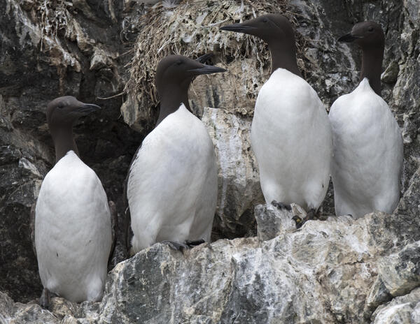
Skinny Common Murre with keel protruding (second from the left)
Skinny Common Murre with keel protruding (second from the left) contrasted by normal murres. Lower Cook Inlet, Alaska.
Skinny Common Murre with keel protruding (second from the left) contrasted by normal murres. Lower Cook Inlet, Alaska.

USGS on the Colville River Delta, Alaska
Alaska Native Science and Engineer Program (ANSEP) student and USGS intern Parker Pickett on the Colville River Delta, Alaska, helping to band molting snow geese and black brant.
Alaska Native Science and Engineer Program (ANSEP) student and USGS intern Parker Pickett on the Colville River Delta, Alaska, helping to band molting snow geese and black brant.

A Black-legged Kittiwake harasses a melanistic Common Murre
A Black-legged Kittiwake harasses a melanistic (all black) Common Murre, forcing it off its breeding site in Kachemak Bay, Alaska, 2018. See related paper published in the Marine Ornithology: Journal of Seabird Research and Conservation at: http://www.marineornithology.org/PDF/50_2/50_2_225-22
A Black-legged Kittiwake harasses a melanistic (all black) Common Murre, forcing it off its breeding site in Kachemak Bay, Alaska, 2018. See related paper published in the Marine Ornithology: Journal of Seabird Research and Conservation at: http://www.marineornithology.org/PDF/50_2/50_2_225-22

Before and after views of Kasatochi Volcano's eruption of 2008
Before and after views of Kasatochi Volcano's eruption of 2008
Before and after views of Kasatochi Volcano's eruption of 2008

Glaucous-winged Gulls grab eggs abandoned by breeding Common Murres
Glaucous-winged Gulls capitalize upon a disturbance at the Gull Island colony in 2018 to grab eggs abandoned by breeding Common Murres. One lone Common Murre continues incubation despite the rest of the colony flushing.
Glaucous-winged Gulls capitalize upon a disturbance at the Gull Island colony in 2018 to grab eggs abandoned by breeding Common Murres. One lone Common Murre continues incubation despite the rest of the colony flushing.