
Fishing for lake trout (Salvelinus namaycush) in Wrangell St. Elias National Park. Sam Graf (NPS – LACL) and Ashley Stanek (USGS – ASC) angle for lake trout (Salvelinus namaycush) in Wrangell St. Elias National Park as part of a study examining mercury in lake food webs.
Images
Browse images from a wide range of science topics covered by USGS. All items in this gallery are considered public domain unless otherwise noted.
Filter Total Items: 1458

Fishing for lake trout in Wrangell St. Elias National Park
Fishing for lake trout (Salvelinus namaycush) in Wrangell St. Elias National Park. Sam Graf (NPS – LACL) and Ashley Stanek (USGS – ASC) angle for lake trout (Salvelinus namaycush) in Wrangell St. Elias National Park as part of a study examining mercury in lake food webs.

Burbot in Wrangell St. Elias National Park
Burbot in Wrangell St. Elias National Park. Burbot (Lota lota) were collected as part of a study examining mercury in lake food webs.
Burbot in Wrangell St. Elias National Park. Burbot (Lota lota) were collected as part of a study examining mercury in lake food webs.

Fyke net in Wrangell St. Elias National Park
Fyke net in Wrangell St. Elias National Park. Sam Graf (NPS – LACL) adjusts a fyke net installed in a lake in Wrangell St. Elias National Park. Fyke nets are used to non-lethally capture fish.
Fyke net in Wrangell St. Elias National Park. Sam Graf (NPS – LACL) adjusts a fyke net installed in a lake in Wrangell St. Elias National Park. Fyke nets are used to non-lethally capture fish.
Arctic grayling in Wrangell St. Elias National Park
Arctic grayling (Thymallus arcticus) in Wrangell St. Elias National Park. Arctic grayling were collected as part of a study examining mercury in lake food webs.
Arctic grayling (Thymallus arcticus) in Wrangell St. Elias National Park. Arctic grayling were collected as part of a study examining mercury in lake food webs.

Lake trout sampling
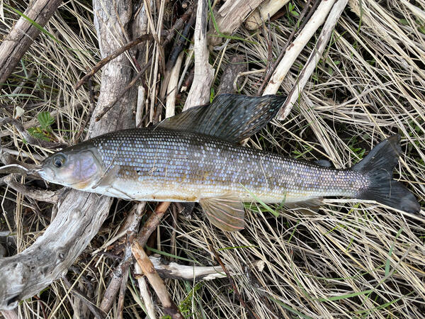
Lake trout with stomach contents in Wrangell St. Elias National Park. Dorsal muscle collection and stomach content analysis are used to evaluate biomagnification of mercury in Lake trout (Salvelinus namaycush). Stomach contents visible below the fish consist primarily of slimy sculpin (Cottus cognatus).
Lake trout with stomach contents in Wrangell St. Elias National Park. Dorsal muscle collection and stomach content analysis are used to evaluate biomagnification of mercury in Lake trout (Salvelinus namaycush). Stomach contents visible below the fish consist primarily of slimy sculpin (Cottus cognatus).

Collecting benthic macroinvertebrates
Collecting benthic macroinvertebrates in Wrangell St. Elias National Park. Sarah Laske (USGS – ASC) collects benthic macroinvertebrates using a kick net in a lake in Wrangell St. Elias National Park, Alaska, as part of a study examining mercury in lake food webs.
Collecting benthic macroinvertebrates in Wrangell St. Elias National Park. Sarah Laske (USGS – ASC) collects benthic macroinvertebrates using a kick net in a lake in Wrangell St. Elias National Park, Alaska, as part of a study examining mercury in lake food webs.

Collecting benthic macroinvertebrates in Wrangell St. Elias National Park
Sam Graf (NPS – LACL) collects benthic macroinvertebrates using an Eckman grab in Wrangell St. Elias National Park as part of a study examining mercury in lake food webs.
Sam Graf (NPS – LACL) collects benthic macroinvertebrates using an Eckman grab in Wrangell St. Elias National Park as part of a study examining mercury in lake food webs.

Collecting zooplankton in Wrangell St. Elias National Park
Sarah Laske (USGS - ASC) collects zooplankton from a lake using a plankton net in Wrangell St. Elias National Park as part of a study examining mercury in lake food webs. Sam Graf (NPS - LACL) angles.
Sarah Laske (USGS - ASC) collects zooplankton from a lake using a plankton net in Wrangell St. Elias National Park as part of a study examining mercury in lake food webs. Sam Graf (NPS - LACL) angles.

USFWS aerial survey for sea otters
Example of a screen capture of machine learning assisted image processing with OtterChecker9000 from the USFWS aerial survey for sea otters in Southeast AK.
Example of a screen capture of machine learning assisted image processing with OtterChecker9000 from the USFWS aerial survey for sea otters in Southeast AK.

Tributary of Agashashok River, Noatak National Park and Preserve, Alaska
Tributary of Agashashok River located in the Noatak National Park and Preserve, Alaska. Recent observations from Arctic Alaska indicate that waters draining permafrost landscapes may be susceptible to iron and carbon mobilization following thaw.
Tributary of Agashashok River located in the Noatak National Park and Preserve, Alaska. Recent observations from Arctic Alaska indicate that waters draining permafrost landscapes may be susceptible to iron and carbon mobilization following thaw.

Three marine mammal trainers measure a healthy female walrus
Sea World Orlando marine mammal trainers, Kelly Trotto, Josh Boepple and Matt Oddi, measure a healthy mature female walrus in support of a USGS study that seeks to develop methods to monitor walrus body condition from survey drones flown high above walruses where they rest on shore. With this new tool, USGS intends to examine the environmental factors that affe
Sea World Orlando marine mammal trainers, Kelly Trotto, Josh Boepple and Matt Oddi, measure a healthy mature female walrus in support of a USGS study that seeks to develop methods to monitor walrus body condition from survey drones flown high above walruses where they rest on shore. With this new tool, USGS intends to examine the environmental factors that affe

Laura Geissinger watching sea otters through a spotting scope
Graduate student Laura Geissinger looks through a spotting scope. The student is watching sea otters in Kachemak Bay forage. USGS researchers spend hundreds of hours annually observing sea otter foraging behavior to document prey composition and energy recovery rates.
Graduate student Laura Geissinger looks through a spotting scope. The student is watching sea otters in Kachemak Bay forage. USGS researchers spend hundreds of hours annually observing sea otter foraging behavior to document prey composition and energy recovery rates.

Walrus at SeaWorld Orlando, Florida as part of USGS research
An adult female walrus being positioned by marine mammal trainers at SeaWorld Orlando, Florida for measurement using aerial photographs (see camera at the top of the image). These images were taken as part of a USGS study in collaboration with zoos and aquaria in the United States and western Europe for validating aerial imagery as a method for monitoring the b
An adult female walrus being positioned by marine mammal trainers at SeaWorld Orlando, Florida for measurement using aerial photographs (see camera at the top of the image). These images were taken as part of a USGS study in collaboration with zoos and aquaria in the United States and western Europe for validating aerial imagery as a method for monitoring the b

Plane with camera
Image depicting the new camera system USGS, FWS, and NPS are using to conduct photo-based aerial surveys for sea otters.
Image depicting the new camera system USGS, FWS, and NPS are using to conduct photo-based aerial surveys for sea otters.

Study site locations for waterbird and Arctic lake ecosystem research on the Arctic Coastal Plain of Alaska
linkThe Teshekpuk Lake region was designated as a Special Area in 1977 by the Secretary of the Interior, Cecil Andrus. The map shows the approximate boundary of the Special Area in 2008, 2013, and 2020.

Marine mammal trainers measure a healthy female walrus
Indianapolis Zoo marine mammal trainers, Erika Allen and Sydney Pitts, measure a healthy female walrus in support of a USGS study that seeks to develop methods to monitor walrus body condition from survey drones flown high above walruses where they rest on shore. With this new tool, USGS intends to examine the environmental factors that affect walrus body condi
Indianapolis Zoo marine mammal trainers, Erika Allen and Sydney Pitts, measure a healthy female walrus in support of a USGS study that seeks to develop methods to monitor walrus body condition from survey drones flown high above walruses where they rest on shore. With this new tool, USGS intends to examine the environmental factors that affect walrus body condi

Sagavanirktok River Winter Streamflow Measurement at USGS Station 15908000
Sagavanirktok River Winter Streamflow Measurement at USGS Station 15908000. Ice augers are used to drill through river ice in order to measure ice thickness, water depth, and water velocity under the ice. The total streamflow under the ice is computed with these measurements from 25 holes across the channel.
Sagavanirktok River Winter Streamflow Measurement at USGS Station 15908000. Ice augers are used to drill through river ice in order to measure ice thickness, water depth, and water velocity under the ice. The total streamflow under the ice is computed with these measurements from 25 holes across the channel.

Intern designs graphic showing how USGS collects and releases bird species checklist data to the public
linkThis is a graphical abstract depicting the process that the USGS Alaska Science Center uses for compiling and releasing bird species checklist data to the public via USGS and eBird. Scientists from the USGS Alaska Science Center regularly work in remote field camps, often for days or weeks at a time.

Lake trout otolith section
Cross section of a lake trout (Salvelinus namaycush) otolith collected from a fish in Lake Clark National Park. Otoliths, also known as 'earstones' are hard, calcium carbonate structures located directly behind the brain of bony fishes.
Cross section of a lake trout (Salvelinus namaycush) otolith collected from a fish in Lake Clark National Park. Otoliths, also known as 'earstones' are hard, calcium carbonate structures located directly behind the brain of bony fishes.
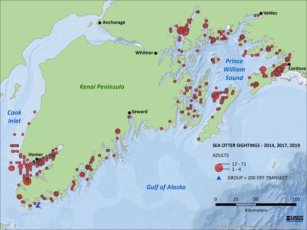
Density estimate of sea otters in southcentral Alaska
Density estimate of sea otters in southcentral Alaska from aerial surveys flown in 2014, 2017, and 2019. Sea otters in southcentral Alaska are the northernmost stock of sea otters and a keystone predator because they are known for structuring nearshore marine ecosystems through their feeding habits. Biologists with the USGS and USFWS conducted aerial
Density estimate of sea otters in southcentral Alaska from aerial surveys flown in 2014, 2017, and 2019. Sea otters in southcentral Alaska are the northernmost stock of sea otters and a keystone predator because they are known for structuring nearshore marine ecosystems through their feeding habits. Biologists with the USGS and USFWS conducted aerial
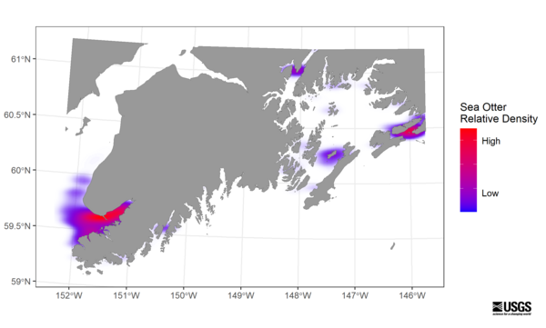
Distribution map of sea otters in southcentral Alaska
Distribution map of sea otters in southcentral Alaska from aerial surveys flown in 2014, 2017, and 2019.
Distribution map of sea otters in southcentral Alaska from aerial surveys flown in 2014, 2017, and 2019.