
Groundwater and Streamflow Information
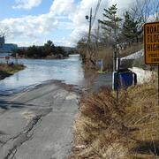
Surface-water Monitoring, Groundwater monitoring, and Flood Hazards
Surface-water Monitoring, Groundwater monitoring, and Flood Hazards
Water Use and Availability
Surface-water Modeling, Groundwater-flow Modeling, Hydrogeologic Characterization, Water Use, Flood Science, Climate Change
Surface-water Modeling, Groundwater-flow Modeling, Hydrogeologic Characterization, Water Use, Flood Science, Climate Change
Water Quality
Surface-water-quality Monitoring, Groundwater-quality Monitoring, Water-quality Modeling, Wetlands, Ecosystem Health
Surface-water-quality Monitoring, Groundwater-quality Monitoring, Water-quality Modeling, Wetlands, Ecosystem Health
Coastal Science
Beach and Barrier Dynamics, Flood Hazards, Nearshore Environmental Health, Tide and Wave Hydrodynamics, Wetlands, Climate and Land-Use Change
Beach and Barrier Dynamics, Flood Hazards, Nearshore Environmental Health, Tide and Wave Hydrodynamics, Wetlands, Climate and Land-Use Change
Ecosystem Health
Aquatic Community Health, Biogeochemical and Hydrologic Assessment, Climate Change, Ecological Assessment of Human and Natural Impacts
Aquatic Community Health, Biogeochemical and Hydrologic Assessment, Climate Change, Ecological Assessment of Human and Natural Impacts
New York Water Science Center
The New York Water Science Center will provide the hydrologic observations, research, and modeling needed for full integration of hydrogeologic, physiochemical, biological, and landscape processes across the freshwater to marine continuum.


NY WSC Quick Links
NY WSC Quick Links
Explore some of our most popular science topics, data, and tools
News
USGS Satellites and Test Tubes Meet to Ensure Safe Drinking Water
USGS Satellites and Test Tubes Meet to Ensure Safe Drinking Water
Advanced Quantitative Precipitation Information System Enhances Flood Prediction in San Francisco Bay Area
Advanced Quantitative Precipitation Information System Enhances Flood Prediction in San Francisco Bay Area
Native American Research Assistantship Student Learns USGS Water Science
Native American Research Assistantship Student Learns USGS Water Science
Publications
The Long Island Sound and Watershed Metadata map application
The Long Island Sound and its watershed encompass an area of about 17,000 square miles and include the Connecticut, Housatonic, and Thames Rivers, which all drain to the sound. Dozens of organizations from government agencies, nonprofits, and Tribal Nations have developed projects and monitoring programs to analyze and protect the water resources of the watershed and sound. The abundance...
A geospatial analysis of water-quality threats from orphan wells in principal and secondary aquifers of the United States
Throughout the history of oil and gas production in the United States, millions of wells have been drilled for exploration and energy production. Hundreds of thousands of unplugged wells are no longer actively producing and are currently under orphan status, with no responsible party obligated for plugging. Orphan wells can pose threats to water resources by providing pathways for...
Hydrogeologic framework and considerations for drilling and grouting of closed-loop geothermal bores in the Erie-Ontario Lowlands and Allegheny Plateau of New York State
The hydrogeologic framework at closed-loop geothermal sites in the Erie-Ontario Lowlands and Allegheny Plateau of central and western New York is the result of the complex interaction of bedrock geology, glacial geology, and groundwater hydrology, and the occurrence of petroleum and gas. Considerations for closed-loop geothermal bore installation include the thickness and character of...
Science
Regional Assessment of Compound Flood Hazard from the Combined Effects of Coastal, Stormwater and Groundwater Emergence Flooding
Compound flooding is flooding that results from a co-occurrence of multiple flood drivers. In this project we consider precipitation (pluvial flooding, overland flow of stormwater), coastal storm surge and tidal flooding (coastal flooding), and flooding that occurs as a shallow water table intersects the land surface or critical infrastructure (groundwater emergence flooding). These flooding...

A National Predictive Model for PFAS Occurrence in Groundwater
In October of 2024, USGS Scientist’s published a study where they created a model to predict PFAS occurrence in groundwater at the depths of drinking water supplies. This model can help guide our partners to sample areas where PFAS in drinking water could be an issue for the public.
By
Ecosystems Mission Area, Water Resources Mission Area, Contaminant Biology, Environmental Health Program, Toxic Substances Hydrology, California Water Science Center, Eastern Ecological Science Center, Lower Mississippi-Gulf Water Science Center, New England Water Science Center, New Jersey Water Science Center, New Mexico Water Science Center, New York Water Science Center, Pennsylvania Water Science Center, South Atlantic Water Science Center (SAWSC), Western Ecological Research Center (WERC)

Groundwater Flow Modeling - Long Island, New York
Numerical models provide a means to synthesize existing hydrogeologic information into an internally consistent mathematical representation of a real system or process, and thus are useful tools for testing and improving conceptual models or hypotheses of groundwater flow systems. The goal of this effort is to develop a regional model for the Long Island aquifer system to simulate changes in water...