
FAQs
Frequently asked questions

What are some of the signs of climate change?
• Temperatures are rising world-wide due to greenhouse gases trapping more heat in the atmosphere. • Droughts are becoming longer and more extreme around the world. • Tropical storms becoming more severe due to warmer ocean water temperatures. • As temperatures rise there is less snowpack in mountain ranges and polar areas and the snow melts faster. • Overall, glaciers are melting at a faster rate...

How can climate change affect natural disasters?
With increasing global surface temperatures the possibility of more droughts and increased intensity of storms will likely occur. As more water vapor is evaporated into the atmosphere it becomes fuel for more powerful storms to develop. More heat in the atmosphere and warmer ocean surface temperatures can lead to increased wind speeds in tropical storms. Rising sea levels expose higher locations...

Does the USGS monitor global warming?
Not specifically. Our charge is to understand characteristics of the Earth, especially the Earth's surface, that affect our Nation's land, water, and biological resources. That includes quite a bit of environmental monitoring. Other agencies, especially NOAA and NASA, are specifically funded to monitor global temperature and atmospheric phenomena such as ozone concentrations. The work through...

How do changes in climate and land use relate to one another?
The link between land use and the climate is complex. First, land cover--as shaped by land use practices--affects the global concentration of greenhouse gases. Second, while land use change is an important driver of climate change, a changing climate can lead to changes in land use and land cover. For example, farmers might shift from their customary crops to crops that will have higher economic...

What is Lidar data and where can I download it?
Light Detection and Ranging ( lidar ) is a technology used to create high-resolution models of ground elevation with a vertical accuracy of 10 centimeters (4 inches). Lidar equipment, which includes a laser scanner, a Global Positioning System (GPS), and an Inertial Navigation System (INS), is typically mounted on a small aircraft. The laser scanner transmits brief pulses of light to the ground...

What is remote sensing and what is it used for?
Remote sensing is the process of detecting and monitoring the physical characteristics of an area by measuring its reflected and emitted radiation at a distance (typically from satellite or aircraft). Special cameras collect remotely sensed images, which help researchers "sense" things about the Earth. Some examples are: Cameras on satellites and airplanes take images of large areas on the Earth's...

Why is the ocean salty?
Oceans cover about 70 percent of the Earth's surface and about 97 percent of all water on and in the Earth is saline —there's a lot of salty water on our planet. By some estimates, if the salt in the ocean could be removed and spread evenly over the Earth’s land surface it would form a layer more than 500 feet (166 meters) thick, about the height of a 40-story office building. But, where did all...
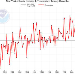
How do we know the climate is changing?
The scientific community is certain that the Earth's climate is changing because of the trends that we see in the instrumented climate record and the changes that have been observed in physical and biological systems. The instrumental record of climate change is derived from thousands of temperature and precipitation recording stations around the world. We have very high confidence in these...

What is a geographic information system (GIS)?
A Geographic Information System (GIS) is a computer system that analyzes and displays geographically referenced information. It uses data that is attached to a unique location. Most of the information we have about our world contains a location reference: Where are USGS streamgages located? Where was a rock sample collected? Exactly where are all of a city's fire hydrants? If, for example, a rare...
Has the USGS made any Biologic Carbon Sequestration assessments?
The USGS is congressionally mandated (2007 Energy Independence and Security Act) to conduct a comprehensive national assessment of storage and flux (flow) of carbon and the fluxes of other greenhouse gases (including carbon dioxide) in ecosystems. At this writing, reports have been completed for Alaska , the Eastern U.S. , the Great Plains , and the Western U.S. Learn more: Land Change Science...

How does carbon get into the atmosphere?
Atmospheric carbon dioxide comes from two primary sources—natural and human activities. Natural sources of carbon dioxide include most animals, which exhale carbon dioxide as a waste product. Human activities that lead to carbon dioxide emissions come primarily from energy production, including burning coal, oil, or natural gas. Learn more: Sources of Greenhouse Gas Emissions (EPA)

What is carbon sequestration?
Carbon dioxide is the most commonly produced greenhouse gas. Carbon sequestration is the process of capturing and storing atmospheric carbon dioxide. It is one method of reducing the amount of carbon dioxide in the atmosphere with the goal of reducing global climate change. The USGS is conducting assessments on two major types of carbon sequestration: geologic and biologic .