


Mount Rainier volcano looms over Puyallup Valley, near Orting, Washington.
Where does the United States rank in the number of volcanoes?
The United States ranks third, behind Indonesia and Japan, in the number of historically active volcanoes (that is, those for which we have written accounts of eruptions). In addition, about 10 percent of the more than 1,500 volcanoes that have erupted in the past 10,000 years are located in the United States. Most of these volcanoes are found in the Aleutian Islands, the Alaska Peninsula, the Hawaiian Islands, and the Cascade Range of the Pacific Northwest.
Related
How many active volcanoes are there on Earth?
There are about 1,350 potentially active volcanoes worldwide, aside from the continuous belts of volcanoes on the ocean floor at spreading centers like the Mid-Atlantic Ridge. About 500 of those 1,350 volcanoes have erupted in historical time. Many of those are located along the Pacific Rim in what is known as the " Ring of Fire." In the United States, volcanoes in the Cascade Range and Alaska...
How much of the Earth is volcanic?
More than 80 percent of the Earth's surface--above and below sea level--is of volcanic origin. Gaseous emissions from volcanic vents over hundreds of millions of years formed the Earth's earliest oceans and atmosphere, which supplied the ingredients vital to evolve and sustain life. Over geologic eons, countless volcanic eruptions have produced mountains, plateaus, and plains, which subsequently...
What are some benefits of volcanic eruptions?
Over geologic time, volcanic eruptions and related processes have directly and indirectly benefited mankind: Volcanic materials ultimately break down and weather to form some of the most fertile soils on Earth, cultivation of which has produced abundant food and fostered civilizations. The internal heat associated with young volcanic systems has been harnessed to produce geothermal energy. Most of...
What was the most destructive volcanic eruption in the history of the United States?
The May 18, 1980 eruption of Mount St. Helens (Washington) was the most destructive in the history of the United States. Novarupta (Katmai) Volcano in Alaska erupted considerably more material in 1912, but owing to the isolation and sparse population of the region, there were no human deaths and little property damage. In contrast, the eruption of Mount St. Helens caused loss of lives and...
Where is the largest active volcano in the world?
Rising gradually to more than 4 km (2.5 mi) above sea level, Hawaii’s Mauna Loa is the largest active volcano on our planet. Its submarine flanks descend to the sea floor an additional 5 km (3 mi), and the sea floor in turn is depressed by Mauna Loa's great mass another 8 km (5 mi). This makes the volcano's summit about 17 km (10.5 mi) above its base! Learn more: USGS Hawaiian Volcano Observatory
Which volcanic eruptions were the deadliest?
Deadliest Volcanic Eruptions Since 1500 A.D. Eruption Year Casualties Major Cause Nevado del Ruiz, Colombia 1985 25,000 1,3 Mudflows 3 Mont Pelée, Martinique 1902 30,000 1 (29,025) 2 Pyroclastic flows 2 Krakatau, Indonesia 1883 36,000 1 (36,417) 2 Tsunami 2 Tambora, Indonesia 1815 92,000 1,2 Starvation 2 Unzendake, Japan 1792 15,000 1 (14,030) 2 Volcano collapse, Tsunami 2 Lakagigar (Laki)...
Which volcanoes in the contiguous United States have erupted since the Nation was founded?
Excluding steam eruptions, these volcanoes have shown activity: Mount St. Helens, Washington - Eruptions and/or lava dome growth occurred in the late 1700s, 1800-1857, 1980-1986, and 2004-2008. Lassen Peak, California - A series of steam blasts began on May 30, 1914. An eruption occurred 12 months later on May 21, 1915. Minor activity continued through the middle of 1917. Mount Hood, Oregon -...
What was the largest volcanic eruption in the 20th century?
The world's largest eruption of the 20th century occurred in 1912 at Novarupta on the Alaska Peninsula in what is now Katmai National Park and Preserve. An estimated 15 cubic kilometers of magma was explosively erupted during 60 hours beginning on June 6th. This volume is equivalent to 230 years of eruption at Kilauea (Hawaii) or about 30 times the volume erupted by Mount St. Helens (Washington)...

Mount Rainier Looms over the Puyallup Valley, Washington
Mount Rainier volcano looms over Puyallup Valley, near Orting, Washington.

Mount Hood, OR
View of Mount Hood from Pittock Mansion, Portland, OR.
View of Mount Hood from Pittock Mansion, Portland, OR.

Littoral Explosion At Kilauea Volcano, Hawai'i
When lava from the Pu'u 'Ō'ō-Kupaianaha eruption, active since 1983, meets the ocean, large littoral explosions can result.
When lava from the Pu'u 'Ō'ō-Kupaianaha eruption, active since 1983, meets the ocean, large littoral explosions can result.

A gas plume arising from Augustine Volcano during it's eruptive phase 2005-06.
A gas plume arising from Augustine Volcano during it's eruptive phase 2005-06. This photo was taken during a FLIR/maintenance flight on January 24, 2006.
A gas plume arising from Augustine Volcano during it's eruptive phase 2005-06. This photo was taken during a FLIR/maintenance flight on January 24, 2006.

Mount St. Helens (left) and Mount Rainier viewed toward the north.
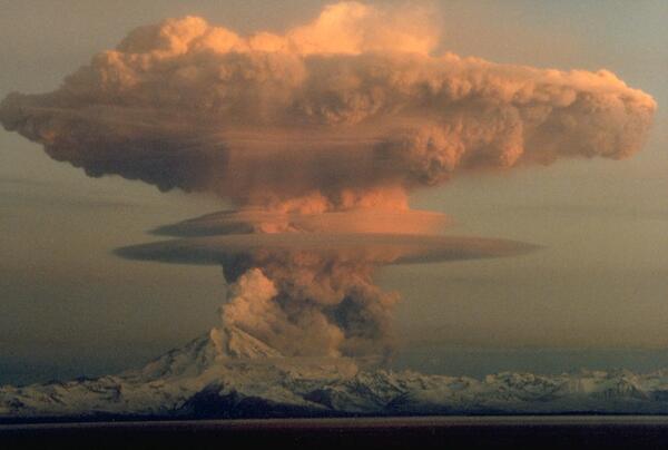
Redoubt Volcano
Ascending eruption cloud from Redoubt Volcano as viewed to the west from the Kenai Peninsula. The mushroom-shaped plume rose from avalanches of hot debris (pyroclastic flows) that cascaded down the north flank of the volcano. A smaller, white steam plume rises from the summit crater.
Ascending eruption cloud from Redoubt Volcano as viewed to the west from the Kenai Peninsula. The mushroom-shaped plume rose from avalanches of hot debris (pyroclastic flows) that cascaded down the north flank of the volcano. A smaller, white steam plume rises from the summit crater.

Cascade Volcanoes
The volcanoes from closest to farthest are Mt. Washington, Three Fingered Jack, Mt. Jefferson. This picture is taken from Middle Sister looking north in the Cascade Range, Three Sisters Wilderness Area, Deschutes National Forest, Oregon.
The volcanoes from closest to farthest are Mt. Washington, Three Fingered Jack, Mt. Jefferson. This picture is taken from Middle Sister looking north in the Cascade Range, Three Sisters Wilderness Area, Deschutes National Forest, Oregon.
Related
How many active volcanoes are there on Earth?
There are about 1,350 potentially active volcanoes worldwide, aside from the continuous belts of volcanoes on the ocean floor at spreading centers like the Mid-Atlantic Ridge. About 500 of those 1,350 volcanoes have erupted in historical time. Many of those are located along the Pacific Rim in what is known as the " Ring of Fire." In the United States, volcanoes in the Cascade Range and Alaska...
How much of the Earth is volcanic?
More than 80 percent of the Earth's surface--above and below sea level--is of volcanic origin. Gaseous emissions from volcanic vents over hundreds of millions of years formed the Earth's earliest oceans and atmosphere, which supplied the ingredients vital to evolve and sustain life. Over geologic eons, countless volcanic eruptions have produced mountains, plateaus, and plains, which subsequently...
What are some benefits of volcanic eruptions?
Over geologic time, volcanic eruptions and related processes have directly and indirectly benefited mankind: Volcanic materials ultimately break down and weather to form some of the most fertile soils on Earth, cultivation of which has produced abundant food and fostered civilizations. The internal heat associated with young volcanic systems has been harnessed to produce geothermal energy. Most of...
What was the most destructive volcanic eruption in the history of the United States?
The May 18, 1980 eruption of Mount St. Helens (Washington) was the most destructive in the history of the United States. Novarupta (Katmai) Volcano in Alaska erupted considerably more material in 1912, but owing to the isolation and sparse population of the region, there were no human deaths and little property damage. In contrast, the eruption of Mount St. Helens caused loss of lives and...
Where is the largest active volcano in the world?
Rising gradually to more than 4 km (2.5 mi) above sea level, Hawaii’s Mauna Loa is the largest active volcano on our planet. Its submarine flanks descend to the sea floor an additional 5 km (3 mi), and the sea floor in turn is depressed by Mauna Loa's great mass another 8 km (5 mi). This makes the volcano's summit about 17 km (10.5 mi) above its base! Learn more: USGS Hawaiian Volcano Observatory
Which volcanic eruptions were the deadliest?
Deadliest Volcanic Eruptions Since 1500 A.D. Eruption Year Casualties Major Cause Nevado del Ruiz, Colombia 1985 25,000 1,3 Mudflows 3 Mont Pelée, Martinique 1902 30,000 1 (29,025) 2 Pyroclastic flows 2 Krakatau, Indonesia 1883 36,000 1 (36,417) 2 Tsunami 2 Tambora, Indonesia 1815 92,000 1,2 Starvation 2 Unzendake, Japan 1792 15,000 1 (14,030) 2 Volcano collapse, Tsunami 2 Lakagigar (Laki)...
Which volcanoes in the contiguous United States have erupted since the Nation was founded?
Excluding steam eruptions, these volcanoes have shown activity: Mount St. Helens, Washington - Eruptions and/or lava dome growth occurred in the late 1700s, 1800-1857, 1980-1986, and 2004-2008. Lassen Peak, California - A series of steam blasts began on May 30, 1914. An eruption occurred 12 months later on May 21, 1915. Minor activity continued through the middle of 1917. Mount Hood, Oregon -...
What was the largest volcanic eruption in the 20th century?
The world's largest eruption of the 20th century occurred in 1912 at Novarupta on the Alaska Peninsula in what is now Katmai National Park and Preserve. An estimated 15 cubic kilometers of magma was explosively erupted during 60 hours beginning on June 6th. This volume is equivalent to 230 years of eruption at Kilauea (Hawaii) or about 30 times the volume erupted by Mount St. Helens (Washington)...
Mount Rainier Looms over the Puyallup Valley, Washington
Mount Rainier volcano looms over Puyallup Valley, near Orting, Washington.
Mount Rainier volcano looms over Puyallup Valley, near Orting, Washington.
Mount Hood, OR
View of Mount Hood from Pittock Mansion, Portland, OR.
View of Mount Hood from Pittock Mansion, Portland, OR.
Littoral Explosion At Kilauea Volcano, Hawai'i
When lava from the Pu'u 'Ō'ō-Kupaianaha eruption, active since 1983, meets the ocean, large littoral explosions can result.
When lava from the Pu'u 'Ō'ō-Kupaianaha eruption, active since 1983, meets the ocean, large littoral explosions can result.
A gas plume arising from Augustine Volcano during it's eruptive phase 2005-06.
A gas plume arising from Augustine Volcano during it's eruptive phase 2005-06. This photo was taken during a FLIR/maintenance flight on January 24, 2006.
A gas plume arising from Augustine Volcano during it's eruptive phase 2005-06. This photo was taken during a FLIR/maintenance flight on January 24, 2006.
Mount St. Helens (left) and Mount Rainier viewed toward the north.
Redoubt Volcano
Ascending eruption cloud from Redoubt Volcano as viewed to the west from the Kenai Peninsula. The mushroom-shaped plume rose from avalanches of hot debris (pyroclastic flows) that cascaded down the north flank of the volcano. A smaller, white steam plume rises from the summit crater.
Ascending eruption cloud from Redoubt Volcano as viewed to the west from the Kenai Peninsula. The mushroom-shaped plume rose from avalanches of hot debris (pyroclastic flows) that cascaded down the north flank of the volcano. A smaller, white steam plume rises from the summit crater.
Cascade Volcanoes
The volcanoes from closest to farthest are Mt. Washington, Three Fingered Jack, Mt. Jefferson. This picture is taken from Middle Sister looking north in the Cascade Range, Three Sisters Wilderness Area, Deschutes National Forest, Oregon.
The volcanoes from closest to farthest are Mt. Washington, Three Fingered Jack, Mt. Jefferson. This picture is taken from Middle Sister looking north in the Cascade Range, Three Sisters Wilderness Area, Deschutes National Forest, Oregon.
Updated Date: January 24, 2023