
A view of the western portion of the lava lake within Halema‘uma‘u, at the summit of Kīlauea. This photo, taken from the west crater rim, shows the active west vent (lower right), the main island (upper left), and the old west vent from the Dec. 2020–May 2021 eruption (lower left).
Images
Hawaiian Volcano Observatory images of eruptive activity, field work, and more.
Filter Total Items: 2880

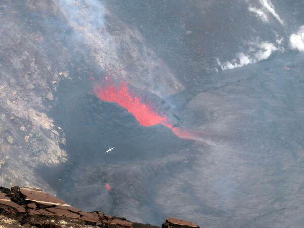
October 13, 2021 — Kīlauea summit eruption
A view of the western portion of the lava lake within Halema‘uma‘u, at the summit of Kīlauea. This photo, taken from the west crater rim, shows the active west vent (lower right), the main island (upper left), and the old west vent from the Dec. 2020–May 2021 eruption (lower left).

Kīlauea summit eruption - October 12, 2021
A view of the fountaining at the west vent in Halema‘uma‘u crater, at the summit of Kīlauea. The photo was taken from the west rim, looking down upon the vent. Low fountaining and roiling within the cone supplied lava to the lake via a narrow spillway. Lava spreading out into the lake develops a zig-zag pattern in the surface crust. USGS photo by M.
A view of the fountaining at the west vent in Halema‘uma‘u crater, at the summit of Kīlauea. The photo was taken from the west rim, looking down upon the vent. Low fountaining and roiling within the cone supplied lava to the lake via a narrow spillway. Lava spreading out into the lake develops a zig-zag pattern in the surface crust. USGS photo by M.

Kīlauea summit eruption - October 12, 2021
A wide view of the ongoing eruption at Kīlauea summit, from the south rim of Halema‘uma‘u. A vent on the western crater wall (left) continues to supply lava to the active west half of the lava lake.
A wide view of the ongoing eruption at Kīlauea summit, from the south rim of Halema‘uma‘u. A vent on the western crater wall (left) continues to supply lava to the active west half of the lava lake.

Kīlauea summit eruption - October 12, 2021
Associated with an increase in fountaining activity at the main western vent in Halema‘uma‘u, a short-lived vent opened just to the north (right). Activity at this vent lasted about 10 hours with low-level fountaining about 3 meters (10 ft) high.
Associated with an increase in fountaining activity at the main western vent in Halema‘uma‘u, a short-lived vent opened just to the north (right). Activity at this vent lasted about 10 hours with low-level fountaining about 3 meters (10 ft) high.
Kīlauea summit eruption - October 12, 2021
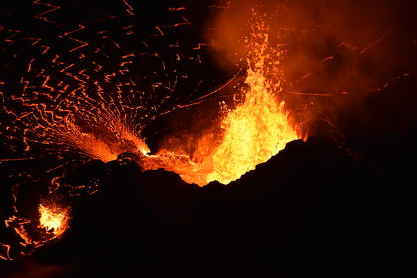
Lava fountains from the western vent within Halema‘uma‘u continue to supply lava into the lava lake through a short spillway. Consistent fountain heights of 10–15 meters (30–50 ft) were interrupted by frequent larger busts of spatter exceeding the height of the cone (30 m or 100 ft). USGS photo taken by B. Carr on October 12, 2021.
Lava fountains from the western vent within Halema‘uma‘u continue to supply lava into the lava lake through a short spillway. Consistent fountain heights of 10–15 meters (30–50 ft) were interrupted by frequent larger busts of spatter exceeding the height of the cone (30 m or 100 ft). USGS photo taken by B. Carr on October 12, 2021.

VMAP Vog Dashboard: public forecast for October 11, 2021
VMAP Vog Dashboard: public forecast for October 11, 2021. Colors denote probability of exceeding ‘Moderate’ sulfur dioxide air quality threshold. Source: http://weather.hawaii.edu/vmap/new/
VMAP Vog Dashboard: public forecast for October 11, 2021. Colors denote probability of exceeding ‘Moderate’ sulfur dioxide air quality threshold. Source: http://weather.hawaii.edu/vmap/new/

October 11, 2021 — Kīlauea
This zoomed-in view of the western fissure within Halema‘uma‘u, at the summit of Kīlauea, was captured on October 11, 2021, through the lens of a laser rangefinder. A prominent horseshoe-shaped spatter cone, measured to be standing 28 m (92 ft) above the adjacent lava lake, surrounds a roiling lava pond which also hosts taller fountains at times.
This zoomed-in view of the western fissure within Halema‘uma‘u, at the summit of Kīlauea, was captured on October 11, 2021, through the lens of a laser rangefinder. A prominent horseshoe-shaped spatter cone, measured to be standing 28 m (92 ft) above the adjacent lava lake, surrounds a roiling lava pond which also hosts taller fountains at times.

October 11, 2021 — Kīlauea
This zoomed-in view of the northwest side of the main island within the Halema‘uma‘u lava lake shows a "rootless lava flow" (silver) that formed in the early stages of the eruption on September 29, 2021.
This zoomed-in view of the northwest side of the main island within the Halema‘uma‘u lava lake shows a "rootless lava flow" (silver) that formed in the early stages of the eruption on September 29, 2021.

October 10, 2021 — Kīlauea, lava fountaining in Halema‘uma‘u
Fountaining at the western vent in Halema‘uma‘u crater, at Kīlauea volcano's summit, was approximately 15 meters (50 feet) high on the evening of October 10, 2021. Spatter from the fountaining would occasionally land on the wall of the vent cone and cool (visible on the right).
Fountaining at the western vent in Halema‘uma‘u crater, at Kīlauea volcano's summit, was approximately 15 meters (50 feet) high on the evening of October 10, 2021. Spatter from the fountaining would occasionally land on the wall of the vent cone and cool (visible on the right).

October 10, 2021 — Kīlauea, Halema‘uma‘u lava lake at dusk
Lava fountaining activity continues from the western vent in Halema‘uma‘u, within Kīlauea summit caldera, viewed at dusk on October 10, 2021, from the west rim of the crater. Only the western half of the lake surface is active; the eastern half is covered by a cooling, solidified crust. USGS image by B. Carr.
Lava fountaining activity continues from the western vent in Halema‘uma‘u, within Kīlauea summit caldera, viewed at dusk on October 10, 2021, from the west rim of the crater. Only the western half of the lake surface is active; the eastern half is covered by a cooling, solidified crust. USGS image by B. Carr.

October 9, 2021 — Kīlauea, summit eruptive vent
HVO scientists captured this zoomed-in photo of the western fissure within Halema‘uma‘u through the lens of a laser rangefinder on October 9, 2021. The fissure has formed a horseshoe-shaped spatter cone around its source, with an opening on the east (right) side allowing lava to flow into the active lava lake.
HVO scientists captured this zoomed-in photo of the western fissure within Halema‘uma‘u through the lens of a laser rangefinder on October 9, 2021. The fissure has formed a horseshoe-shaped spatter cone around its source, with an opening on the east (right) side allowing lava to flow into the active lava lake.

October 8, 2021 — Kīlauea summit eruption
In this overflight photo of the Halema‘uma‘u lava lake, captured on October 8, 2021 and looking from the northeast, two western fissures are visible: one inactive from the December 2020–May 2021 Kīlauea summit eruption (center), and another actively feeding lava into the lake at this time (upper-right).
In this overflight photo of the Halema‘uma‘u lava lake, captured on October 8, 2021 and looking from the northeast, two western fissures are visible: one inactive from the December 2020–May 2021 Kīlauea summit eruption (center), and another actively feeding lava into the lake at this time (upper-right).

October 8, 2021 — Kīlauea summit eruption
On the morning of October 8, 2021, HVO scientists completed a routine helicopter overflight of the ongoing eruption within Halema‘uma‘u at the summit of Kīlauea.
On the morning of October 8, 2021, HVO scientists completed a routine helicopter overflight of the ongoing eruption within Halema‘uma‘u at the summit of Kīlauea.

October 8, 2021 — Kīlauea summit eruption
Though not every ānuenue (rainbow) has an actively erupting volcanic fissure at its end, this one did for a brief moment during HVO scientists' helicopter overflight of the Kīlauea summit on the morning of October 8, 2021.
Though not every ānuenue (rainbow) has an actively erupting volcanic fissure at its end, this one did for a brief moment during HVO scientists' helicopter overflight of the Kīlauea summit on the morning of October 8, 2021.
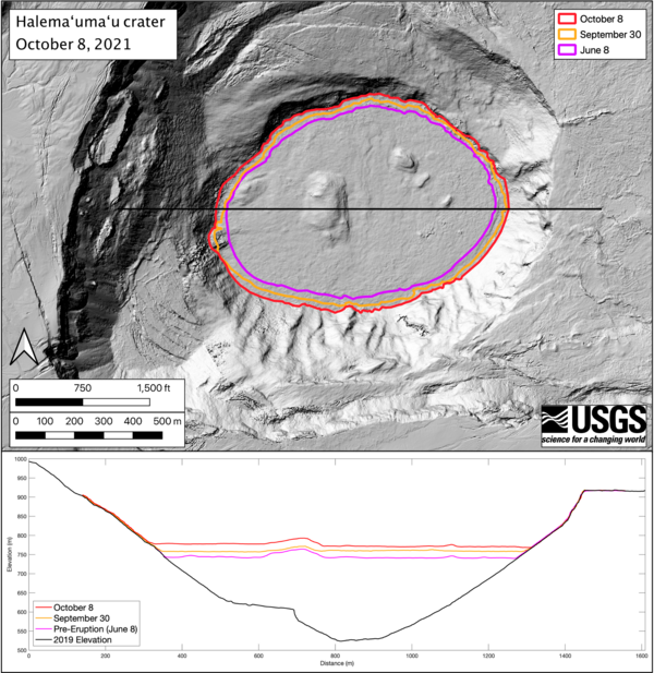
October 8, 2021 — Kīlauea, Halema‘uma‘u Lava Lake Growth
The eruption within Halema‘uma‘u crater, at Kīlauea's summit, continues to feed a growing lava lake. Photos taken during helicopter overflights of the crater allow HVO scientists to create elevation maps of the rising lake’s surface. The surface area of the Halema‘uma‘u lava lake is now 553000 square meters, or 157 acres.
The eruption within Halema‘uma‘u crater, at Kīlauea's summit, continues to feed a growing lava lake. Photos taken during helicopter overflights of the crater allow HVO scientists to create elevation maps of the rising lake’s surface. The surface area of the Halema‘uma‘u lava lake is now 553000 square meters, or 157 acres.
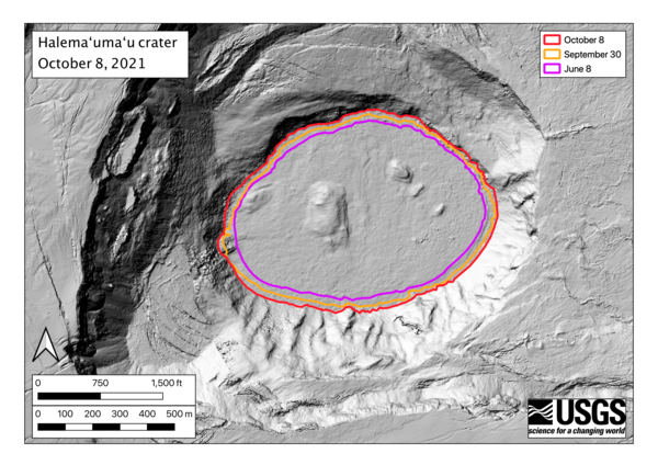
October 8, 2021 — Kīlauea, Halema‘uma‘u Lava Lake Growth
The surface area of the Halema‘uma‘u lava lake at the summit of Kīlauea is now 553,000 square meters, or 157 acres. At its widest point, the lake is a kilometer wide (0.62 mile).
The surface area of the Halema‘uma‘u lava lake at the summit of Kīlauea is now 553,000 square meters, or 157 acres. At its widest point, the lake is a kilometer wide (0.62 mile).
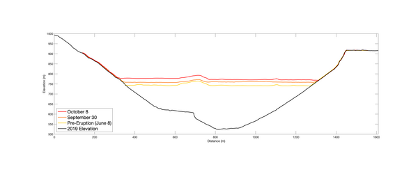
October 8, 2021 — Kīlauea, Halema‘uma‘u Lava Lake Depth
The elevation profiles running East-West across Halema‘uma‘u crater show the rise of the lava lake surface during the ongoing eruption at the summit of Kīlauea. The lake lake is now about 260 m (850 feet) deep, and has risen nearly 30 m (98 feet) above the previous lake surface since the eruption began on September 29.
The elevation profiles running East-West across Halema‘uma‘u crater show the rise of the lava lake surface during the ongoing eruption at the summit of Kīlauea. The lake lake is now about 260 m (850 feet) deep, and has risen nearly 30 m (98 feet) above the previous lake surface since the eruption began on September 29.
October 8, 2021 — Kīlauea, active west vent in Halema‘uma‘u crater
A Koa‘e Kea (white-tailed tropicbird) flies above the erupting west vent within Halema‘uma‘u crater, at the summit of Kīlauea. Photo taken from the south rim of Halema‘uma‘u at 10:41 a.m. HST on Oct. 8, 2021. USGS photo by J.M. Chang.
A Koa‘e Kea (white-tailed tropicbird) flies above the erupting west vent within Halema‘uma‘u crater, at the summit of Kīlauea. Photo taken from the south rim of Halema‘uma‘u at 10:41 a.m. HST on Oct. 8, 2021. USGS photo by J.M. Chang.
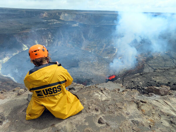
October 8, 2021 — Kīlauea summit eruption monitoring
USGS scientist takes video of the erupting west vent within Halema‘uma‘u crater, at the summit of Kīlauea. Photo taken from the northwest rim of Halema‘uma‘u at 12:27 p.m. HST on Oct. 8, 2021. USGS photo by J.M. Chang.
USGS scientist takes video of the erupting west vent within Halema‘uma‘u crater, at the summit of Kīlauea. Photo taken from the northwest rim of Halema‘uma‘u at 12:27 p.m. HST on Oct. 8, 2021. USGS photo by J.M. Chang.
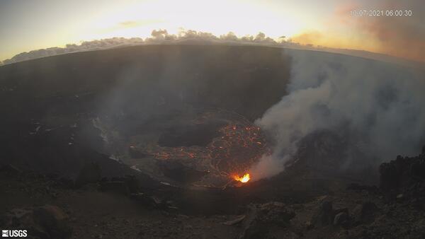
Kīlauea summit eruption in Halemaʻumaʻu crater - October 7, 2021
KWcam image taken on October 7, 2021, just after 6 a.m. HST. This image shows the ongoing eruption within Halemaʻumaʻu crater at the summit of Kīlauea. The eruption began the afternoon of September 29, 2021, as fissures in the floor of the crater; this activity is generating a lava lake that is slowly filling the crater.
KWcam image taken on October 7, 2021, just after 6 a.m. HST. This image shows the ongoing eruption within Halemaʻumaʻu crater at the summit of Kīlauea. The eruption began the afternoon of September 29, 2021, as fissures in the floor of the crater; this activity is generating a lava lake that is slowly filling the crater.

October 7, 2021 — Kīlauea
The eruption continues in Halema‘uma‘u crater, at the summit of Kīlauea. Lava fountaining no longer emerges from the central portion of the lake, with fountaining limited to the west vent shown here. Low fountaining within the cone supplies lava into the lake via a short spillway. USGS image by M. Patrick.
The eruption continues in Halema‘uma‘u crater, at the summit of Kīlauea. Lava fountaining no longer emerges from the central portion of the lake, with fountaining limited to the west vent shown here. Low fountaining within the cone supplies lava into the lake via a short spillway. USGS image by M. Patrick.