An official website of the United States government
Here's how you know
Official websites use .gov
A .gov website belongs to an official government organization in the United States.
Secure .gov websites use HTTPS
A lock () or https:// means you’ve safely connected to the .gov website. Share sensitive information only on official, secure websites.
This photograph of Kīlauea's ongoing middle East Rift Zone eruption was captured during a Hawaiian Volcano Observatory helicopter overflight during the morning of September 17, 2024. Geologists observed fountaining eruptive fissures and active lava flows on the floor of Nāpau Crater, just downrift (northeast) of the September 15 eruptive fissure. This south-facing view shows the current activity from the north side of Nāpau Crater. USGS photo by A. Ellis.
Timeline of eruption events:
Magma intruded beneath the ground near Makaopuhi Crater—a well-known magma storage region on Kīlauea’s middle East Rift Zone on September 14. HVO published a Status Report alerting the public and partners to the activity, which was accompanied by hundreds of earthquakes and ground deformation.
PHASE 1: a brief eruption occurred west of Nāpau Crater on the middle East Rift Zone between 9 and 10 p.m. HST on September 15. 2024. Infrasound sensors in HVO’s monitoring network recorded strong signals indicative of gas or steam venting. At the same time, HVO’s seismometers recorded weak but sustained low frequency tremor. Although an eruption could not be confirmed visually Sunday night by webcams or satellite thermal data due to heavy rainfall, the geophysical data indicated that an eruption could be taking place. That night, some residents in nearby communities also reported strong sulfur or burning smells. The alert level and aviation color code for Kīlauea is raised to ORANGE/WATCH. During an overflight the next morning, geologists observed that a 480-meter (1600-foot) long fissure had covered 16,500 square meters (4 acres) with about 20,000 cubic meters (about 5 million gallons) of lava. Lava was no longer flowing on the surface as of Monday, but magma was still moving underground as detected by seismometers, tiltmeters and GPS.
During the USGS Hawaiian Volcano Observatory reconnaissance overflight the morning of September 19, geologists observed the fissure west of Nāpau Crater generating a lava flow that travels northeast before cascading into the crater on the remote middle East Rift Zone of Kīlauea. This aerial view is looking in a south direction, from north of the eruption site. Nāpau Crater is in the left part of the photo. USGS photo by M. Zoeller.
PHASE 2: NOAA GOES satellite thermal imagery and HVO webcam imagery detect that the eruption has resumed around 6 p.m. HST on September 16. Interestingly, no changes were detected in other monitoring datasets. Fissures from this phase of the eruption produced lava fountains and flows that gradually decreased through the night. But activity would soon resume.
PHASE 3: Between 4 and 5 a.m. HST September 17, infrasound signals, a GOES satellite thermal anomaly, and webcam imagery indicated that the eruption had resumed. After sunrise, HVO scientists on a helicopter overflight observed new vents had opened in Nāpau Crater, with several lava fountains approximately 10 meters (yards) high generating lava flows on the floor of Nāpau Crater. This eruptive phase was more vigorous, l longer lived and continued at gradually decreasing levels through Wednesday afternoon. In total, the fissure system has stretched over 1.6 kilometers (1.0 miles) of the East Rift Zone, with lava flows now covering 18 hectares (44 acres).
PHASE 4: At 3:15 p.m. HST, on September 18, new eruptive fissures opened west of Nāpau Crater. A monitoring camera deployed by HVO field crews with permission from Hawaiʻi Volcanoes National Park recorded “lava falls” cascading down the northwest walls of Nāpau Crater. Vigorous activity continued and by the morning of September 19, about 2/3 of Nāpau Crater floor had been covered with new lava. As of 10 a.m. HST on September 20 morning, phase 4 eruptive activity had paused.
On September 19, USGS Hawaiian Volcano Observatory geologists were able to capture this video of the fissurevent eruption west of Nāpau Crater on the middle East Rift Zone of Kīlauea. They observed a 150-m-long (nearly 500 feet) fissure west of the crater erupting lava in a curtain of lava 10-20 meters (33-66 feet) high. USGS video by M. Zoeller.
September 19 and 20 eruption reference and thermal map
A helicopter overflight on September 20, 2024, allowed for aerial visual and thermal imagery to be collected at the middle East Rift Zone eruption site on Kīlauea. This thermal map shows that the eruption at Nāpau Crater had paused this morning, with no fountaining or active lava on the surface. Shortly after these morning thermal images were collected, a small portion of the fissure system briefly reactivated, but soon died out again. As of this afternoon, the eruption was again in a pause. The scale of the thermal map ranges from blue to red, with blue colors indicative of cooler temperatures and red colors indicative of warmer temperatures.
This reference map depicts fissures and lava flows from the Kīlauea middle East Rift Zone eruption on Thursday, September 19, 2024. Map data are current as of the Hawaiian Volcano Observatory helicopter overflight that occurred between 9:00 and 10:00 a.m. Areas in bright red represent new lava flows since the area was last mapped late on September 18, with these new flows now covering most of the floor of Nāpau Crater. In total, the fissure system has stretched over 1.8 kilometers (1.1 miles) of the East Rift Zone, with the lava flows now covering 63 hectares (156 acres).
Hazards
Far-reaching - VOG
High level of volcanic gas—primarily water vapor (H2O), and sulfur dioxide (SO2)—are emitted during eruptions and can have far-reaching effects downwind. As SO2 is released from lava, it reacts in the atmosphere to create the visible haze known as vog (volcanic smog) that has been observed downwind of eruptive vents. Vog creates the potential for airborne health hazards to residents and visitors, damages agricultural crops and other plants, and affects livestock. For more information on gas hazards at the summit of Kīlauea, please see: https://pubs.er.usgs.gov/publication/fs20173017. Vog information can be found at https://vog.ivhhn.org.
This photograph of Kīlauea's ongoing middle East Rift Zone eruption was captured during a Hawaiian Volcano Observatory helicopter overflight during the morning of September 17, 2024. This photo was taken at 8:11 am H.S.T. Geologists observed fountaining eruptive fissures and active lava flows bisecting the floor of Nāpau Crater, just downrift (northeast) of the September 15 eruptive fissure. This south-facing view shows the current activity from the west side of the crater. USGS photo by N. Deligne.
Additional ground cracking and outbreaks of lava around the active fissures are possible at any time, or existing fissures can be reactivated.
Hawaiian lava flows generally advance slowly downslope and can be avoided by people. They destroy everything in their paths. If new lava flows cover and burn vegetation and soil, they can ignite natural gas pockets in the subsurface, which can cause methane explosions. These explosions can blast lava fragments up to several meters (yards) away and can be hazardous to observers.
Hazards associated with active or recent lava flows include hot and glassy (sharp) surfaces that can cause serious burns, abrasions, and lacerations upon contact with unprotected or exposed skin; uneven and rough terrain can lead to falls and other injuries; hot temperatures that can cause heat exhaustion or dehydration, or in heavy rain can produce steamy ground-fog that can be acidic, severely limiting visibility and sometimes causing difficulty breathing.
Pele's hair and other lightweight volcanic glass fragments from lava fountains and spattering will fall downwind, dusting the ground within a few hundred meters (yards) of the vent. High winds may waft lighter particles and transport them greater distances downwind. Exposure to these volcanic particles can cause skin and eye irritation.
USGS Hawaiian Volcano Observatory geologists collected a sample of the middle East Rift Zone Kīlauea eruption in Nāpau Crater, within a closed area Hawaiʻi Volcanoes National Park. Geologists put molten lava into a metal bucket and rapidly quench it with water.
Low-angle view of fissures bisecting Nāpau Crater during the eruption of Kīlauea's middle East Rift Zone, September 17, 2024
This photograph of Kīlauea's ongoing middle East Rift Zone eruption was captured during a Hawaiian Volcano Observatory helicopter overflight during the morning of September 17, 2024. This low-angle view looking southwest shows three lava fountains; the tallest is approximately 10 meters (30 feet) high.
This photograph of Kīlauea's ongoing middle East Rift Zone eruption was captured during a Hawaiian Volcano Observatory helicopter overflight during the morning of September 17, 2024. This low-angle view looking southwest shows three lava fountains; the tallest is approximately 10 meters (30 feet) high.
PWcam views of the eruption in Nāpau Crater on September 17, 2024
The PWcam is located on the west flank of Pu‘u‘ō‘ō on the middle East Rift Zone of Kīlauea. The webcam looks to the west and provides views of the eruption within Nāpau Crater in the distance. USGS webcam image.
The PWcam is located on the west flank of Pu‘u‘ō‘ō on the middle East Rift Zone of Kīlauea. The webcam looks to the west and provides views of the eruption within Nāpau Crater in the distance. USGS webcam image.
Lava flow erupted west of Nāpau Crater on the middle East Rift Zone of Kīlauea, observed September 16, 2024
During a USGS Hawaiian Volcano Observatory overflight at approximately 10:30 a.m. HST on September 16, geologists observed freshly erupted lava west of Nāpau Crater on the remote middle East Rift Zone of Kīlauea, within Hawaiʻi Volcanoes National Park. This eruption likely occurred between approximately 9–10 p.m. HST on September 15.
During a USGS Hawaiian Volcano Observatory overflight at approximately 10:30 a.m. HST on September 16, geologists observed freshly erupted lava west of Nāpau Crater on the remote middle East Rift Zone of Kīlauea, within Hawaiʻi Volcanoes National Park. This eruption likely occurred between approximately 9–10 p.m. HST on September 15.
September 16, 2024 —Kīlauea middle East Rift Zone eruption reference map
This reference map depicts the fissure and lava flows from the Kīlauea middle East Rift Zone eruption of Sunday, September 15, 2024. The eruption occurred between approximately 9:00 and 10:00 p.m., in a remote and closed area of Hawaiʻi Volcanoes National Park.
This reference map depicts the fissure and lava flows from the Kīlauea middle East Rift Zone eruption of Sunday, September 15, 2024. The eruption occurred between approximately 9:00 and 10:00 p.m., in a remote and closed area of Hawaiʻi Volcanoes National Park.
September 16, 2024 — Thermal map of small eruption on Kīlauea East Rift Zone
This thermal map shows two small lava pads erupted late on September 15, just west of Nāpau Crater on the East Rift Zone of Kīlauea. This small eruption resulted from magma intruding from the summit into the East Rift Zone, and was associated with an increase in earthquake activity along the East Rift Zone.
This thermal map shows two small lava pads erupted late on September 15, just west of Nāpau Crater on the East Rift Zone of Kīlauea. This small eruption resulted from magma intruding from the summit into the East Rift Zone, and was associated with an increase in earthquake activity along the East Rift Zone.
September 16, 2024 — Overflight video of eruption site near Nāpau Crater, Kīlauea
A brief, small eruption occurred on the middle East Rift Zone of Kīlauea late on September 15. The eruption produced two small pads of lava just west of Nāpau Crater, which is west (uprift) of the former Pu‘u‘ō‘ō eruption site.
A brief, small eruption occurred on the middle East Rift Zone of Kīlauea late on September 15. The eruption produced two small pads of lava just west of Nāpau Crater, which is west (uprift) of the former Pu‘u‘ō‘ō eruption site.
September 16, 2024 —Kīlauea middle East Rift Zone eruption overflight
This video, taken during a Hawaiian Volcano Observatory morning overflight of Kīlaueaʻs middle East Rift Zone on September 16, 2024, shows new lava flows erupted over about an hour during the evening on September 15, 2024.
This video, taken during a Hawaiian Volcano Observatory morning overflight of Kīlaueaʻs middle East Rift Zone on September 16, 2024, shows new lava flows erupted over about an hour during the evening on September 15, 2024.
September 16, 2024—Brief eruption near Nāpau Crater on Kīlauea Middle East Rift Zone
During a USGS Hawaiian Volcano Observatory overflight at approximately 10:30 a.m. HST on September 16, geologists observed freshly erupted lava west of Nāpau Crater on the remote middle East Rift Zone of Kīlauea, within Hawaiʻi Volcanoes National Park. This eruption likely occurred between approximately 9–10 p.m. HST on September 15.
During a USGS Hawaiian Volcano Observatory overflight at approximately 10:30 a.m. HST on September 16, geologists observed freshly erupted lava west of Nāpau Crater on the remote middle East Rift Zone of Kīlauea, within Hawaiʻi Volcanoes National Park. This eruption likely occurred between approximately 9–10 p.m. HST on September 15.
September 16, 2024 —Kīlauea middle East Rift Zone eruption
An east-facing view showing Nāpau Crater in the background and the recent eruption in the foreground. This brief eruption took place on the middle East Rift Zone of Kīlauea over about an hour during heavy rain that obscured webcam views the evening of September 15, 2024. USGS photo by M. Zoeller.
An east-facing view showing Nāpau Crater in the background and the recent eruption in the foreground. This brief eruption took place on the middle East Rift Zone of Kīlauea over about an hour during heavy rain that obscured webcam views the evening of September 15, 2024. USGS photo by M. Zoeller.
September 16, 2024 —Kīlauea middle East Rift Zone eruption preliminary reference map
This reference map depicts the approximate location of the fissures that erupted from the Kīlauea middle East Rift Zone, likely between approximately 9:00 and 10:00 p.m. HST on Sunday 15, 2024, in a remote and closed area of Hawaiʻi Volcanoes National Park. Small lava pads erupted from two fissure segments in a couple hundred meters (hundred yards).
This reference map depicts the approximate location of the fissures that erupted from the Kīlauea middle East Rift Zone, likely between approximately 9:00 and 10:00 p.m. HST on Sunday 15, 2024, in a remote and closed area of Hawaiʻi Volcanoes National Park. Small lava pads erupted from two fissure segments in a couple hundred meters (hundred yards).
Steam rises from a new lava flow erupted west of Nāpau Crater on the middle East Rift Zone of Kīlauea, September 16, 2024
During a USGS Hawaiian Volcano Observatory overflight at approximately 10:30 a.m. HST on September 16, geologists observed steam rising above freshly erupted lava west of Nāpau Crater on the remote middle East Rift Zone of Kīlauea, within Hawaiʻi Volcanoes National Park. This eruption likely occurred between approximately 9–10 p.m.
During a USGS Hawaiian Volcano Observatory overflight at approximately 10:30 a.m. HST on September 16, geologists observed steam rising above freshly erupted lava west of Nāpau Crater on the remote middle East Rift Zone of Kīlauea, within Hawaiʻi Volcanoes National Park. This eruption likely occurred between approximately 9–10 p.m.
Dead vegetation surrounded by fresh lava observed on Hawaiian Volcano Observatory overflight at ~10:30 a.m. HST, September 16, 2024
Dead trees and vegetation are surrounded by freshly erupted lava west of Nāpau Crater on the remote middle East Rift Zone of Kīlauea, within Hawaiʻi Volcanoes National Park. This eruption likely occurred between approximately 9–10 p.m. HST on September 15. USGS photo by M. Zoeller.
Dead trees and vegetation are surrounded by freshly erupted lava west of Nāpau Crater on the remote middle East Rift Zone of Kīlauea, within Hawaiʻi Volcanoes National Park. This eruption likely occurred between approximately 9–10 p.m. HST on September 15. USGS photo by M. Zoeller.
This photograph of Kīlauea's ongoing middle East Rift Zone eruption was captured during a Hawaiian Volcano Observatory helicopter overflight during the morning of September 17, 2024. Geologists observed fountaining eruptive fissures and active lava flows on the floor of Nāpau Crater, just downrift (northeast) of the September 15 eruptive fissure. This south-facing view shows the current activity from the north side of Nāpau Crater. USGS photo by A. Ellis.
Timeline of eruption events:
Magma intruded beneath the ground near Makaopuhi Crater—a well-known magma storage region on Kīlauea’s middle East Rift Zone on September 14. HVO published a Status Report alerting the public and partners to the activity, which was accompanied by hundreds of earthquakes and ground deformation.
PHASE 1: a brief eruption occurred west of Nāpau Crater on the middle East Rift Zone between 9 and 10 p.m. HST on September 15. 2024. Infrasound sensors in HVO’s monitoring network recorded strong signals indicative of gas or steam venting. At the same time, HVO’s seismometers recorded weak but sustained low frequency tremor. Although an eruption could not be confirmed visually Sunday night by webcams or satellite thermal data due to heavy rainfall, the geophysical data indicated that an eruption could be taking place. That night, some residents in nearby communities also reported strong sulfur or burning smells. The alert level and aviation color code for Kīlauea is raised to ORANGE/WATCH. During an overflight the next morning, geologists observed that a 480-meter (1600-foot) long fissure had covered 16,500 square meters (4 acres) with about 20,000 cubic meters (about 5 million gallons) of lava. Lava was no longer flowing on the surface as of Monday, but magma was still moving underground as detected by seismometers, tiltmeters and GPS.
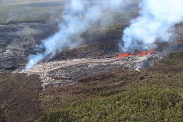
During the USGS Hawaiian Volcano Observatory reconnaissance overflight the morning of September 19, geologists observed the fissure west of Nāpau Crater generating a lava flow that travels northeast before cascading into the crater on the remote middle East Rift Zone of Kīlauea. This aerial view is looking in a south direction, from north of the eruption site. Nāpau Crater is in the left part of the photo. USGS photo by M. Zoeller.
PHASE 2: NOAA GOES satellite thermal imagery and HVO webcam imagery detect that the eruption has resumed around 6 p.m. HST on September 16. Interestingly, no changes were detected in other monitoring datasets. Fissures from this phase of the eruption produced lava fountains and flows that gradually decreased through the night. But activity would soon resume.
PHASE 3: Between 4 and 5 a.m. HST September 17, infrasound signals, a GOES satellite thermal anomaly, and webcam imagery indicated that the eruption had resumed. After sunrise, HVO scientists on a helicopter overflight observed new vents had opened in Nāpau Crater, with several lava fountains approximately 10 meters (yards) high generating lava flows on the floor of Nāpau Crater. This eruptive phase was more vigorous, l longer lived and continued at gradually decreasing levels through Wednesday afternoon. In total, the fissure system has stretched over 1.6 kilometers (1.0 miles) of the East Rift Zone, with lava flows now covering 18 hectares (44 acres).
PHASE 4: At 3:15 p.m. HST, on September 18, new eruptive fissures opened west of Nāpau Crater. A monitoring camera deployed by HVO field crews with permission from Hawaiʻi Volcanoes National Park recorded “lava falls” cascading down the northwest walls of Nāpau Crater. Vigorous activity continued and by the morning of September 19, about 2/3 of Nāpau Crater floor had been covered with new lava. As of 10 a.m. HST on September 20 morning, phase 4 eruptive activity had paused.
On September 19, USGS Hawaiian Volcano Observatory geologists were able to capture this video of the fissurevent eruption west of Nāpau Crater on the middle East Rift Zone of Kīlauea. They observed a 150-m-long (nearly 500 feet) fissure west of the crater erupting lava in a curtain of lava 10-20 meters (33-66 feet) high. USGS video by M. Zoeller.
September 19 and 20 eruption reference and thermal map
A helicopter overflight on September 20, 2024, allowed for aerial visual and thermal imagery to be collected at the middle East Rift Zone eruption site on Kīlauea. This thermal map shows that the eruption at Nāpau Crater had paused this morning, with no fountaining or active lava on the surface. Shortly after these morning thermal images were collected, a small portion of the fissure system briefly reactivated, but soon died out again. As of this afternoon, the eruption was again in a pause. The scale of the thermal map ranges from blue to red, with blue colors indicative of cooler temperatures and red colors indicative of warmer temperatures.
This reference map depicts fissures and lava flows from the Kīlauea middle East Rift Zone eruption on Thursday, September 19, 2024. Map data are current as of the Hawaiian Volcano Observatory helicopter overflight that occurred between 9:00 and 10:00 a.m. Areas in bright red represent new lava flows since the area was last mapped late on September 18, with these new flows now covering most of the floor of Nāpau Crater. In total, the fissure system has stretched over 1.8 kilometers (1.1 miles) of the East Rift Zone, with the lava flows now covering 63 hectares (156 acres).
Hazards
Far-reaching - VOG
High level of volcanic gas—primarily water vapor (H2O), and sulfur dioxide (SO2)—are emitted during eruptions and can have far-reaching effects downwind. As SO2 is released from lava, it reacts in the atmosphere to create the visible haze known as vog (volcanic smog) that has been observed downwind of eruptive vents. Vog creates the potential for airborne health hazards to residents and visitors, damages agricultural crops and other plants, and affects livestock. For more information on gas hazards at the summit of Kīlauea, please see: https://pubs.er.usgs.gov/publication/fs20173017. Vog information can be found at https://vog.ivhhn.org.
This photograph of Kīlauea's ongoing middle East Rift Zone eruption was captured during a Hawaiian Volcano Observatory helicopter overflight during the morning of September 17, 2024. This photo was taken at 8:11 am H.S.T. Geologists observed fountaining eruptive fissures and active lava flows bisecting the floor of Nāpau Crater, just downrift (northeast) of the September 15 eruptive fissure. This south-facing view shows the current activity from the west side of the crater. USGS photo by N. Deligne.
Additional ground cracking and outbreaks of lava around the active fissures are possible at any time, or existing fissures can be reactivated.
Hawaiian lava flows generally advance slowly downslope and can be avoided by people. They destroy everything in their paths. If new lava flows cover and burn vegetation and soil, they can ignite natural gas pockets in the subsurface, which can cause methane explosions. These explosions can blast lava fragments up to several meters (yards) away and can be hazardous to observers.
Hazards associated with active or recent lava flows include hot and glassy (sharp) surfaces that can cause serious burns, abrasions, and lacerations upon contact with unprotected or exposed skin; uneven and rough terrain can lead to falls and other injuries; hot temperatures that can cause heat exhaustion or dehydration, or in heavy rain can produce steamy ground-fog that can be acidic, severely limiting visibility and sometimes causing difficulty breathing.
Pele's hair and other lightweight volcanic glass fragments from lava fountains and spattering will fall downwind, dusting the ground within a few hundred meters (yards) of the vent. High winds may waft lighter particles and transport them greater distances downwind. Exposure to these volcanic particles can cause skin and eye irritation.
USGS Hawaiian Volcano Observatory geologists collected a sample of the middle East Rift Zone Kīlauea eruption in Nāpau Crater, within a closed area Hawaiʻi Volcanoes National Park. Geologists put molten lava into a metal bucket and rapidly quench it with water.
Low-angle view of fissures bisecting Nāpau Crater during the eruption of Kīlauea's middle East Rift Zone, September 17, 2024
This photograph of Kīlauea's ongoing middle East Rift Zone eruption was captured during a Hawaiian Volcano Observatory helicopter overflight during the morning of September 17, 2024. This low-angle view looking southwest shows three lava fountains; the tallest is approximately 10 meters (30 feet) high.
This photograph of Kīlauea's ongoing middle East Rift Zone eruption was captured during a Hawaiian Volcano Observatory helicopter overflight during the morning of September 17, 2024. This low-angle view looking southwest shows three lava fountains; the tallest is approximately 10 meters (30 feet) high.
PWcam views of the eruption in Nāpau Crater on September 17, 2024
The PWcam is located on the west flank of Pu‘u‘ō‘ō on the middle East Rift Zone of Kīlauea. The webcam looks to the west and provides views of the eruption within Nāpau Crater in the distance. USGS webcam image.
The PWcam is located on the west flank of Pu‘u‘ō‘ō on the middle East Rift Zone of Kīlauea. The webcam looks to the west and provides views of the eruption within Nāpau Crater in the distance. USGS webcam image.
Lava flow erupted west of Nāpau Crater on the middle East Rift Zone of Kīlauea, observed September 16, 2024
During a USGS Hawaiian Volcano Observatory overflight at approximately 10:30 a.m. HST on September 16, geologists observed freshly erupted lava west of Nāpau Crater on the remote middle East Rift Zone of Kīlauea, within Hawaiʻi Volcanoes National Park. This eruption likely occurred between approximately 9–10 p.m. HST on September 15.
During a USGS Hawaiian Volcano Observatory overflight at approximately 10:30 a.m. HST on September 16, geologists observed freshly erupted lava west of Nāpau Crater on the remote middle East Rift Zone of Kīlauea, within Hawaiʻi Volcanoes National Park. This eruption likely occurred between approximately 9–10 p.m. HST on September 15.
September 16, 2024 —Kīlauea middle East Rift Zone eruption reference map
This reference map depicts the fissure and lava flows from the Kīlauea middle East Rift Zone eruption of Sunday, September 15, 2024. The eruption occurred between approximately 9:00 and 10:00 p.m., in a remote and closed area of Hawaiʻi Volcanoes National Park.
This reference map depicts the fissure and lava flows from the Kīlauea middle East Rift Zone eruption of Sunday, September 15, 2024. The eruption occurred between approximately 9:00 and 10:00 p.m., in a remote and closed area of Hawaiʻi Volcanoes National Park.
September 16, 2024 — Thermal map of small eruption on Kīlauea East Rift Zone
This thermal map shows two small lava pads erupted late on September 15, just west of Nāpau Crater on the East Rift Zone of Kīlauea. This small eruption resulted from magma intruding from the summit into the East Rift Zone, and was associated with an increase in earthquake activity along the East Rift Zone.
This thermal map shows two small lava pads erupted late on September 15, just west of Nāpau Crater on the East Rift Zone of Kīlauea. This small eruption resulted from magma intruding from the summit into the East Rift Zone, and was associated with an increase in earthquake activity along the East Rift Zone.
September 16, 2024 — Overflight video of eruption site near Nāpau Crater, Kīlauea
A brief, small eruption occurred on the middle East Rift Zone of Kīlauea late on September 15. The eruption produced two small pads of lava just west of Nāpau Crater, which is west (uprift) of the former Pu‘u‘ō‘ō eruption site.
A brief, small eruption occurred on the middle East Rift Zone of Kīlauea late on September 15. The eruption produced two small pads of lava just west of Nāpau Crater, which is west (uprift) of the former Pu‘u‘ō‘ō eruption site.
September 16, 2024 —Kīlauea middle East Rift Zone eruption overflight
This video, taken during a Hawaiian Volcano Observatory morning overflight of Kīlaueaʻs middle East Rift Zone on September 16, 2024, shows new lava flows erupted over about an hour during the evening on September 15, 2024.
This video, taken during a Hawaiian Volcano Observatory morning overflight of Kīlaueaʻs middle East Rift Zone on September 16, 2024, shows new lava flows erupted over about an hour during the evening on September 15, 2024.
September 16, 2024—Brief eruption near Nāpau Crater on Kīlauea Middle East Rift Zone
During a USGS Hawaiian Volcano Observatory overflight at approximately 10:30 a.m. HST on September 16, geologists observed freshly erupted lava west of Nāpau Crater on the remote middle East Rift Zone of Kīlauea, within Hawaiʻi Volcanoes National Park. This eruption likely occurred between approximately 9–10 p.m. HST on September 15.
During a USGS Hawaiian Volcano Observatory overflight at approximately 10:30 a.m. HST on September 16, geologists observed freshly erupted lava west of Nāpau Crater on the remote middle East Rift Zone of Kīlauea, within Hawaiʻi Volcanoes National Park. This eruption likely occurred between approximately 9–10 p.m. HST on September 15.
September 16, 2024 —Kīlauea middle East Rift Zone eruption
An east-facing view showing Nāpau Crater in the background and the recent eruption in the foreground. This brief eruption took place on the middle East Rift Zone of Kīlauea over about an hour during heavy rain that obscured webcam views the evening of September 15, 2024. USGS photo by M. Zoeller.
An east-facing view showing Nāpau Crater in the background and the recent eruption in the foreground. This brief eruption took place on the middle East Rift Zone of Kīlauea over about an hour during heavy rain that obscured webcam views the evening of September 15, 2024. USGS photo by M. Zoeller.
September 16, 2024 —Kīlauea middle East Rift Zone eruption preliminary reference map
This reference map depicts the approximate location of the fissures that erupted from the Kīlauea middle East Rift Zone, likely between approximately 9:00 and 10:00 p.m. HST on Sunday 15, 2024, in a remote and closed area of Hawaiʻi Volcanoes National Park. Small lava pads erupted from two fissure segments in a couple hundred meters (hundred yards).
This reference map depicts the approximate location of the fissures that erupted from the Kīlauea middle East Rift Zone, likely between approximately 9:00 and 10:00 p.m. HST on Sunday 15, 2024, in a remote and closed area of Hawaiʻi Volcanoes National Park. Small lava pads erupted from two fissure segments in a couple hundred meters (hundred yards).
Steam rises from a new lava flow erupted west of Nāpau Crater on the middle East Rift Zone of Kīlauea, September 16, 2024
During a USGS Hawaiian Volcano Observatory overflight at approximately 10:30 a.m. HST on September 16, geologists observed steam rising above freshly erupted lava west of Nāpau Crater on the remote middle East Rift Zone of Kīlauea, within Hawaiʻi Volcanoes National Park. This eruption likely occurred between approximately 9–10 p.m.
During a USGS Hawaiian Volcano Observatory overflight at approximately 10:30 a.m. HST on September 16, geologists observed steam rising above freshly erupted lava west of Nāpau Crater on the remote middle East Rift Zone of Kīlauea, within Hawaiʻi Volcanoes National Park. This eruption likely occurred between approximately 9–10 p.m.
Dead vegetation surrounded by fresh lava observed on Hawaiian Volcano Observatory overflight at ~10:30 a.m. HST, September 16, 2024
Dead trees and vegetation are surrounded by freshly erupted lava west of Nāpau Crater on the remote middle East Rift Zone of Kīlauea, within Hawaiʻi Volcanoes National Park. This eruption likely occurred between approximately 9–10 p.m. HST on September 15. USGS photo by M. Zoeller.
Dead trees and vegetation are surrounded by freshly erupted lava west of Nāpau Crater on the remote middle East Rift Zone of Kīlauea, within Hawaiʻi Volcanoes National Park. This eruption likely occurred between approximately 9–10 p.m. HST on September 15. USGS photo by M. Zoeller.