

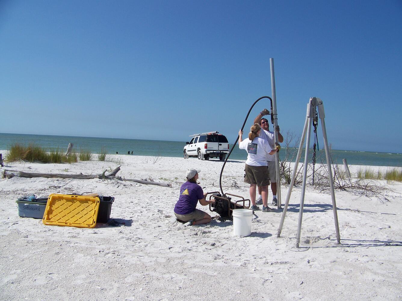
Scientists collected sand auger cores from Fire Island to help reconstruct the evolution of the barrier over the last several centuries, with the goal of quantifying changes in sediment input and partitioning through time (e.g., how sand is distributed between the terrestrial portion of the barrier and the beach/shoreface).
Coastal Sediment Availability and Flux (CSAF) Capabilities
Active
By St. Petersburg Coastal and Marine Science Center
September 15, 2020
As part of the Coastal Sediment Availability and Flux project, we use innovative technology and integrate a variety of techniques to characterize barrier island environments, reconstruct their past history, and predict their future vulnerability.
Geophysics
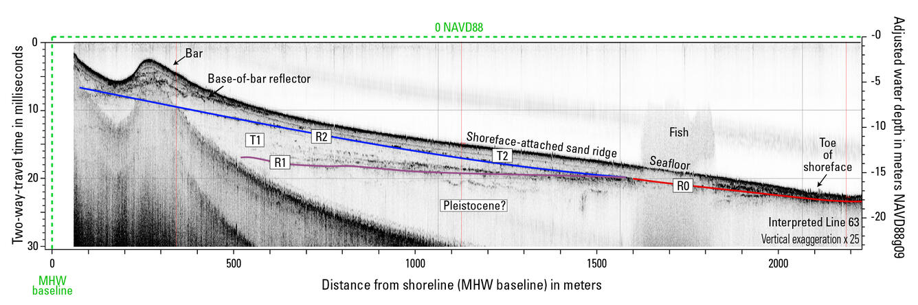
We acquire geophysical data to investigate changes in the shape and geology of inner shelf, shoreface, beach, and barrier environments. In shallow marine environments, we acquire high-resolution multibeam and single-beam bathymetry – data that show the shape and depth of the seafloor. By repeating surveys in the same location annually or semi-annually, we track erosional or depositional processes that might impact the response of the barrier to storms, sea-level rise, or human intervention. We pair bathymetry with sub-bottom geophysics (e.g., Chirp), to explore sediment layers beneath the seafloor. On land, we examine what’s beneath beaches and barriers using ground-penetrating radar (GPR) to learn about their evolution through time.


Remote Sensing
Remote sensing allows us to assess changes in barrier island extent, inlet dynamics, overwash processes, and land cover at varying spatial scales. Different spectra, or frequency ranges, in satellite imagery help us classify land cover features. This is especially useful for rapidly changing coastal features, like new inlets, where we can use multiple forms of remotely sensed imagery to study their evolution.

Sources/Usage: Public Domain. View Media Details

Sources/Usage: Public Domain. View Media Details
Reduced-Complexity Models
We use reduced-complexity models to infer past changes in coastal systems and reconstruct past geomorphology, which can help predict future change. This animation displays modeled beach profile elevation as it has evolved at Parramore Island, Virginia. These data are based on geomorphic field investigations and measure distance (in kilometers) of cross-shore accretion. QS is the flux of sand to the beach and QD is the flux of sand from the beach to the active dune. Yellow represents sand, blue represents water, while green represents marsh.

Sources/Usage: Public Domain. View Media Details
Sediment Sampling
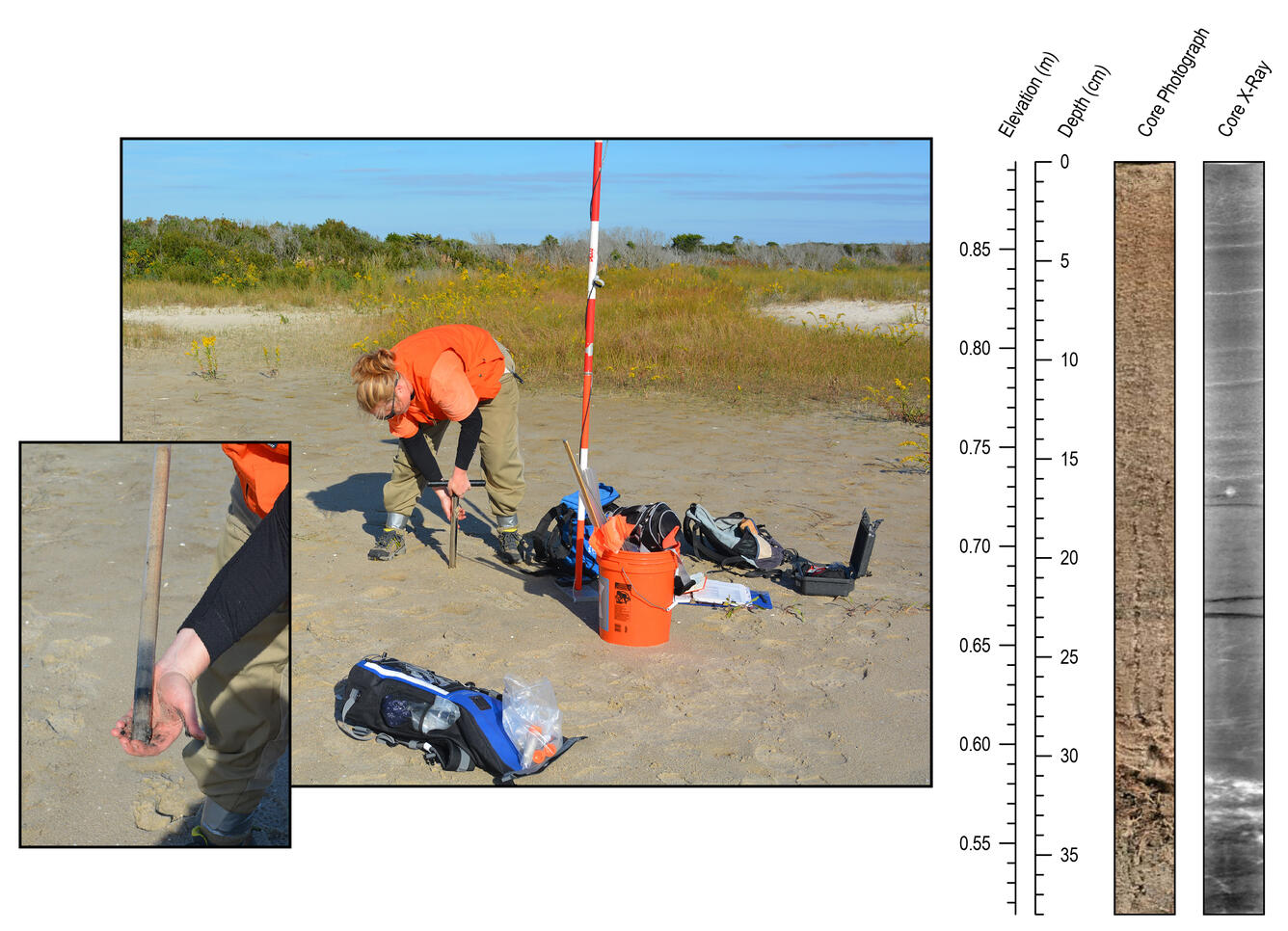
Sediment sampling is used to verify remote sensing observations and can tell us how old sediments are, where they came from, and what processes brought them there. Sediment cores can extend records of erosion and deposition further into the past than geophysical or remote sensing methods.

This research is part of the part of the Coastal Sediment Availability and Flux project.
Coastal Sediment Availability and Flux (CSAF)
Sediments are the foundation of coastal systems, including barrier islands. Their behavior is driven by not only sediment availability, but also sediment exchanges between barrier island environments. We collect geophysical, remote sensing, and sediment data to estimate these parameters, which are integrated with models to improve prediction of coastal response to extreme storms and sea-level rise...

Secrets of the Sediment on Barrier Islands
Join the USGS St. Petersburg Coastal and Marine Science Center as they uncover the secrets of the sediment on barrier islands in Pinellas County, Florida. This video was originally created for use at the 2021 virtual St. Petersburg Science Festival.

Research Geologist Daniel Ciarletta holds up a sand auger core collected at Fire Island
Scientists collected sand auger cores from Fire Island to help reconstruct the evolution of the barrier over the last several centuries, with the goal of quantifying changes in sediment input and partitioning through time (e.g., how sand is distributed between the terrestrial portion of the barrier and the beach/shoreface).

Geologist Julie Bernier examines a water-logged sand auger core
Scientists collected sand auger cores from Fire Island to help reconstruct the evolution of the barrier over the last several centuries, with the goal of quantifying changes in sediment input and partitioning through time (e.g. how sand is distributed between the terrestrial portion of the barrier and the beach/shoreface).
Scientists collected sand auger cores from Fire Island to help reconstruct the evolution of the barrier over the last several centuries, with the goal of quantifying changes in sediment input and partitioning through time (e.g. how sand is distributed between the terrestrial portion of the barrier and the beach/shoreface).

Looking towards the beach in the High Dune Wilderness of Fire Island
Looking over the dunes towards the beach in the Otis Pike Fire Island High Dune Wilderness at Fire Island, New York.
Looking over the dunes towards the beach in the Otis Pike Fire Island High Dune Wilderness at Fire Island, New York.

USACE LARC used for DUNEX field work
USGS Research Geologist Jennifer Miselis will conduct shoreface geophysical surveys at the USACE Field Research Facility during DUNEX aboard the LARC, which is shown here being set up for the survey.
USGS Research Geologist Jennifer Miselis will conduct shoreface geophysical surveys at the USACE Field Research Facility during DUNEX aboard the LARC, which is shown here being set up for the survey.

USGS DUNEX Survey underway off of a USACE amphibious vessel
A geophysical instrument (chirp) is towed in the water (yellow instrument) from a floating sled to acquire information about the geology below the seafloor in Duck, NC as part of DUNEX. The USACE Field Research Facility can be seen in the background in the upper left corner.
A geophysical instrument (chirp) is towed in the water (yellow instrument) from a floating sled to acquire information about the geology below the seafloor in Duck, NC as part of DUNEX. The USACE Field Research Facility can be seen in the background in the upper left corner.

Beach and groin at Seven Mile Island, New Jersey
A groin at Seven Mile Island, New Jersey traps sand and contributes to widening of the barrier beach. This illustrates how human modification and wave processes shape the beach. In May 2021, Andrew Farmer, Chelsea Stalk, and Emily Wei conducted a multibeam bathymetry survey offshore of Seven Mile Island, along the southern coast of New Jersey.
A groin at Seven Mile Island, New Jersey traps sand and contributes to widening of the barrier beach. This illustrates how human modification and wave processes shape the beach. In May 2021, Andrew Farmer, Chelsea Stalk, and Emily Wei conducted a multibeam bathymetry survey offshore of Seven Mile Island, along the southern coast of New Jersey.

Succession of beach ridges, Caladesi Island, Gulf of Mexico coast, FL
Mendenhall postdoctoral fellow Daniel Ciarletta captured this view of the modern beach ridge system at Caladesi Island, along the Gulf coast of central Florida. Ciarletta and colleagues are studying the island as part of a project to explore barrier island response to long-term changes in sediment availability.
Mendenhall postdoctoral fellow Daniel Ciarletta captured this view of the modern beach ridge system at Caladesi Island, along the Gulf coast of central Florida. Ciarletta and colleagues are studying the island as part of a project to explore barrier island response to long-term changes in sediment availability.


Collecting sediment core with vibracore equipment at Mullet Key, FL
Dan Ciarletta (right) working alongside Julie Bernier (left) to collect a sediment core on Mullet Key, an island within Fort de Soto Park in Pinellas County, Florida. The core will be used to reconstruct the geologic history of the island.
Dan Ciarletta (right) working alongside Julie Bernier (left) to collect a sediment core on Mullet Key, an island within Fort de Soto Park in Pinellas County, Florida. The core will be used to reconstruct the geologic history of the island.

Surveying the Beach at Caladesi Island, Gulf of Mexico Coast, Florida
Mendenhall postdoctoral fellow Daniel Ciarletta and geologist Julie Bernier perform field reconnaissance at Caladesi Island, along the Gulf coast of central Florida. The scientists are refining a plan to sample and survey the island using sediment vibracores and ground-penetrating radar.
Mendenhall postdoctoral fellow Daniel Ciarletta and geologist Julie Bernier perform field reconnaissance at Caladesi Island, along the Gulf coast of central Florida. The scientists are refining a plan to sample and survey the island using sediment vibracores and ground-penetrating radar.

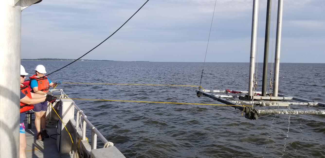
Scientist deploys instrument during geophysical survey
A scientist deploys a sound velocity cast from a boat while conducting a chirp geophysical survey offshore of the Rockaway Peninsula, New York. These geophysical data were used to quantify volumes of available shoreface sediment on this margin.
A scientist deploys a sound velocity cast from a boat while conducting a chirp geophysical survey offshore of the Rockaway Peninsula, New York. These geophysical data were used to quantify volumes of available shoreface sediment on this margin.

Using unique methods to measure nearshore and coastal geology
USGS scientists use specialized equipment to measure sediment dynamics in nearshore and coastal systems. Access by boat is limited in these areas, so personal watercraft are equipped with GPS and echosounders to collect bathymetric data. Seismic sleds are pulled along transects from the beach across the water to measure changes in sediment type below the water.
USGS scientists use specialized equipment to measure sediment dynamics in nearshore and coastal systems. Access by boat is limited in these areas, so personal watercraft are equipped with GPS and echosounders to collect bathymetric data. Seismic sleds are pulled along transects from the beach across the water to measure changes in sediment type below the water.

Scientists collect data on Pelican Island, Alabama
In an effort spanning the Natural Hazards and Ecosystems Mission Areas, pilots from the Saint Petersburg and Woods Hole Coastal and Marine Science Centers collect imagery data using Unmanned Aerial System (UAS) while personnel from the Wetlands and Aquatic Research Center (WARC) conduct ground-based site surveys of Pelican Island, Alabama.
In an effort spanning the Natural Hazards and Ecosystems Mission Areas, pilots from the Saint Petersburg and Woods Hole Coastal and Marine Science Centers collect imagery data using Unmanned Aerial System (UAS) while personnel from the Wetlands and Aquatic Research Center (WARC) conduct ground-based site surveys of Pelican Island, Alabama.
As part of the Coastal Sediment Availability and Flux project, we use innovative technology and integrate a variety of techniques to characterize barrier island environments, reconstruct their past history, and predict their future vulnerability.
Geophysics
We acquire geophysical data to investigate changes in the shape and geology of inner shelf, shoreface, beach, and barrier environments. In shallow marine environments, we acquire high-resolution multibeam and single-beam bathymetry – data that show the shape and depth of the seafloor. By repeating surveys in the same location annually or semi-annually, we track erosional or depositional processes that might impact the response of the barrier to storms, sea-level rise, or human intervention. We pair bathymetry with sub-bottom geophysics (e.g., Chirp), to explore sediment layers beneath the seafloor. On land, we examine what’s beneath beaches and barriers using ground-penetrating radar (GPR) to learn about their evolution through time.
Remote Sensing
Remote sensing allows us to assess changes in barrier island extent, inlet dynamics, overwash processes, and land cover at varying spatial scales. Different spectra, or frequency ranges, in satellite imagery help us classify land cover features. This is especially useful for rapidly changing coastal features, like new inlets, where we can use multiple forms of remotely sensed imagery to study their evolution.
Sources/Usage: Public Domain. View Media Details
Sources/Usage: Public Domain. View Media Details
Reduced-Complexity Models
We use reduced-complexity models to infer past changes in coastal systems and reconstruct past geomorphology, which can help predict future change. This animation displays modeled beach profile elevation as it has evolved at Parramore Island, Virginia. These data are based on geomorphic field investigations and measure distance (in kilometers) of cross-shore accretion. QS is the flux of sand to the beach and QD is the flux of sand from the beach to the active dune. Yellow represents sand, blue represents water, while green represents marsh.
Sources/Usage: Public Domain. View Media Details
Sediment Sampling
Sediment sampling is used to verify remote sensing observations and can tell us how old sediments are, where they came from, and what processes brought them there. Sediment cores can extend records of erosion and deposition further into the past than geophysical or remote sensing methods.
This research is part of the part of the Coastal Sediment Availability and Flux project.
Coastal Sediment Availability and Flux (CSAF)
Sediments are the foundation of coastal systems, including barrier islands. Their behavior is driven by not only sediment availability, but also sediment exchanges between barrier island environments. We collect geophysical, remote sensing, and sediment data to estimate these parameters, which are integrated with models to improve prediction of coastal response to extreme storms and sea-level rise...
Secrets of the Sediment on Barrier Islands
Join the USGS St. Petersburg Coastal and Marine Science Center as they uncover the secrets of the sediment on barrier islands in Pinellas County, Florida. This video was originally created for use at the 2021 virtual St. Petersburg Science Festival.
Research Geologist Daniel Ciarletta holds up a sand auger core collected at Fire Island
Scientists collected sand auger cores from Fire Island to help reconstruct the evolution of the barrier over the last several centuries, with the goal of quantifying changes in sediment input and partitioning through time (e.g., how sand is distributed between the terrestrial portion of the barrier and the beach/shoreface).
Scientists collected sand auger cores from Fire Island to help reconstruct the evolution of the barrier over the last several centuries, with the goal of quantifying changes in sediment input and partitioning through time (e.g., how sand is distributed between the terrestrial portion of the barrier and the beach/shoreface).
Geologist Julie Bernier examines a water-logged sand auger core
Scientists collected sand auger cores from Fire Island to help reconstruct the evolution of the barrier over the last several centuries, with the goal of quantifying changes in sediment input and partitioning through time (e.g. how sand is distributed between the terrestrial portion of the barrier and the beach/shoreface).
Scientists collected sand auger cores from Fire Island to help reconstruct the evolution of the barrier over the last several centuries, with the goal of quantifying changes in sediment input and partitioning through time (e.g. how sand is distributed between the terrestrial portion of the barrier and the beach/shoreface).
Looking towards the beach in the High Dune Wilderness of Fire Island
Looking over the dunes towards the beach in the Otis Pike Fire Island High Dune Wilderness at Fire Island, New York.
Looking over the dunes towards the beach in the Otis Pike Fire Island High Dune Wilderness at Fire Island, New York.
USACE LARC used for DUNEX field work
USGS Research Geologist Jennifer Miselis will conduct shoreface geophysical surveys at the USACE Field Research Facility during DUNEX aboard the LARC, which is shown here being set up for the survey.
USGS Research Geologist Jennifer Miselis will conduct shoreface geophysical surveys at the USACE Field Research Facility during DUNEX aboard the LARC, which is shown here being set up for the survey.
USGS DUNEX Survey underway off of a USACE amphibious vessel
A geophysical instrument (chirp) is towed in the water (yellow instrument) from a floating sled to acquire information about the geology below the seafloor in Duck, NC as part of DUNEX. The USACE Field Research Facility can be seen in the background in the upper left corner.
A geophysical instrument (chirp) is towed in the water (yellow instrument) from a floating sled to acquire information about the geology below the seafloor in Duck, NC as part of DUNEX. The USACE Field Research Facility can be seen in the background in the upper left corner.
Beach and groin at Seven Mile Island, New Jersey
A groin at Seven Mile Island, New Jersey traps sand and contributes to widening of the barrier beach. This illustrates how human modification and wave processes shape the beach. In May 2021, Andrew Farmer, Chelsea Stalk, and Emily Wei conducted a multibeam bathymetry survey offshore of Seven Mile Island, along the southern coast of New Jersey.
A groin at Seven Mile Island, New Jersey traps sand and contributes to widening of the barrier beach. This illustrates how human modification and wave processes shape the beach. In May 2021, Andrew Farmer, Chelsea Stalk, and Emily Wei conducted a multibeam bathymetry survey offshore of Seven Mile Island, along the southern coast of New Jersey.
Succession of beach ridges, Caladesi Island, Gulf of Mexico coast, FL
Mendenhall postdoctoral fellow Daniel Ciarletta captured this view of the modern beach ridge system at Caladesi Island, along the Gulf coast of central Florida. Ciarletta and colleagues are studying the island as part of a project to explore barrier island response to long-term changes in sediment availability.
Mendenhall postdoctoral fellow Daniel Ciarletta captured this view of the modern beach ridge system at Caladesi Island, along the Gulf coast of central Florida. Ciarletta and colleagues are studying the island as part of a project to explore barrier island response to long-term changes in sediment availability.
Collecting sediment core with vibracore equipment at Mullet Key, FL
Dan Ciarletta (right) working alongside Julie Bernier (left) to collect a sediment core on Mullet Key, an island within Fort de Soto Park in Pinellas County, Florida. The core will be used to reconstruct the geologic history of the island.
Dan Ciarletta (right) working alongside Julie Bernier (left) to collect a sediment core on Mullet Key, an island within Fort de Soto Park in Pinellas County, Florida. The core will be used to reconstruct the geologic history of the island.
Surveying the Beach at Caladesi Island, Gulf of Mexico Coast, Florida
Mendenhall postdoctoral fellow Daniel Ciarletta and geologist Julie Bernier perform field reconnaissance at Caladesi Island, along the Gulf coast of central Florida. The scientists are refining a plan to sample and survey the island using sediment vibracores and ground-penetrating radar.
Mendenhall postdoctoral fellow Daniel Ciarletta and geologist Julie Bernier perform field reconnaissance at Caladesi Island, along the Gulf coast of central Florida. The scientists are refining a plan to sample and survey the island using sediment vibracores and ground-penetrating radar.
Scientist deploys instrument during geophysical survey
A scientist deploys a sound velocity cast from a boat while conducting a chirp geophysical survey offshore of the Rockaway Peninsula, New York. These geophysical data were used to quantify volumes of available shoreface sediment on this margin.
A scientist deploys a sound velocity cast from a boat while conducting a chirp geophysical survey offshore of the Rockaway Peninsula, New York. These geophysical data were used to quantify volumes of available shoreface sediment on this margin.
Using unique methods to measure nearshore and coastal geology
USGS scientists use specialized equipment to measure sediment dynamics in nearshore and coastal systems. Access by boat is limited in these areas, so personal watercraft are equipped with GPS and echosounders to collect bathymetric data. Seismic sleds are pulled along transects from the beach across the water to measure changes in sediment type below the water.
USGS scientists use specialized equipment to measure sediment dynamics in nearshore and coastal systems. Access by boat is limited in these areas, so personal watercraft are equipped with GPS and echosounders to collect bathymetric data. Seismic sleds are pulled along transects from the beach across the water to measure changes in sediment type below the water.
Scientists collect data on Pelican Island, Alabama
In an effort spanning the Natural Hazards and Ecosystems Mission Areas, pilots from the Saint Petersburg and Woods Hole Coastal and Marine Science Centers collect imagery data using Unmanned Aerial System (UAS) while personnel from the Wetlands and Aquatic Research Center (WARC) conduct ground-based site surveys of Pelican Island, Alabama.
In an effort spanning the Natural Hazards and Ecosystems Mission Areas, pilots from the Saint Petersburg and Woods Hole Coastal and Marine Science Centers collect imagery data using Unmanned Aerial System (UAS) while personnel from the Wetlands and Aquatic Research Center (WARC) conduct ground-based site surveys of Pelican Island, Alabama.