
Natural Hazards
How do volcanoes erupt?
Can you predict earthquakes?
What is the difference between a tsunami and a tidal wave?
What is a landslide and what causes one?
The USGS monitors and conducts research on a wide range of natural hazards to help decision-makers prepare for and respond to hazard events that threaten life and property.
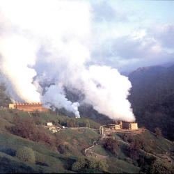
Why are there so many earthquakes in the Geysers area in Northern California?
The Geysers Geothermal Field is located in a tectonically active region of Northern California. The major seismic hazards in the region are from large earthquakes occurring along regional faults that are located miles away from the geothermal field, such as the San Andreas and Healdsburg-Rodgers Creek faults. However, activities associated with the withdrawal of steam for producing electric power...
Can the position of the moon or the planets affect seismicity? Are there more earthquakes in the morning/in the evening/at a certain time of the month?
Earthquakes are equally as likely to occur in the morning or the evening. Many studies in the past have shown no significant correlations between the rate of earthquake occurrence and the semi-diurnal tides when using large earthquake catalogs. Several recent studies, however, have found a correlation between earth tides (caused by the position of the moon relative to the earth) and some types of...

Foreshocks, aftershocks - what's the difference?
"Foreshock" and "aftershock" are relative terms. Foreshocks are earthquakes that precede larger earthquakes in the same location. An earthquake cannot be identified as a foreshock until after a larger earthquake in the same area occurs. Aftershocks are smaller earthquakes that occur in the same general area during the days to years following a larger event or "mainshock." They occur within 1-2...

What is an earthquake and what causes them to happen?
An earthquake is caused by a sudden slip on a fault. The tectonic plates are always slowly moving, but they get stuck at their edges due to friction. When the stress on the edge overcomes the friction, there is an earthquake that releases energy in waves that travel through the earth's crust and cause the shaking that we feel. In California there are two plates - the Pacific Plate and the North...

What is declination?
At most places on the Earth's surface, the compass doesn't point exactly toward geographic north. The deviation of the compass from true north is an angle called "declination" (or "magnetic declination"). It is a quantity that has been a nuisance to navigators for centuries, especially since it varies with both geographic location and time . It might surprise you to know that at very high...

What is it about an earthquake that causes a tsunami?
Although earthquake magnitude is one factor that affects tsunami generation, there are other important factors to consider. The earthquake must be a shallow marine event that displaces the seafloor. Thrust earthquakes (as opposed to strike slip) are far more likely to generate tsunamis, but small tsunamis have occurred in a few cases from large (i.e., > M8) strike-slip earthquakes. Note the...

What is the difference between a tsunami and a tidal wave?
Although both are sea waves, a tsunami and a tidal wave are two different and unrelated phenomena. A tidal wave is a shallow water wave caused by the gravitational interactions between the Sun, Moon, and Earth ("tidal wave" was used in earlier times to describe what we now call a tsunami.) A tsunami is an ocean wave triggered by large earthquakes that occur near or under the ocean, volcanic...

Is there a system to warn populations of an imminent occurrence of a tsunami?
NOAA (National Oceanic and Atmospheric Administration) maintains the U.S. Tsunami Warning Centers , and work in conjunction with USGS seismic networks to help determine when and where to issue tsunami warnings. Also, if an earthquake meets certain criteria for potentially generating a tsunami, the pop-up window and the event page for that earthquake on the USGS Latest Earthquakes Map will include...

What are tsunamis?
Tsunamis are ocean waves triggered by: Large earthquakes that occur near or under the ocean Volcanic eruptions Submarine landslides Onshore landslides in which large volumes of debris fall into the water Scientists do not use the term "tidal wave" because these waves are not caused by tides. Tsunami waves are unlike typical ocean waves generated by wind and storms, and most tsunamis do not "break"...

Could a large tsunami happen in the United States?
Large tsunamis have occurred in the United States and will undoubtedly occur again. Significant earthquakes around the Pacific rim have generated tsunamis that struck Hawaii, Alaska, and the U.S. west coast. One of the largest and most devastating tsunamis that Hawaii has experienced was in 1946 from an earthquake along the Aleutian subduction zone. Runup heights reached a maximum of 33 to 55 feet...

Is the Hawai'i lava-flow hazard zone map still accurate?
Yes, the Map Showing Lava-Flow Hazards Zones on Hawai'i Island is still accurate. It was most recently revised in 1992. The map is intended to communicate long-term lava-flow hazards, rather than short-term hazards, which can change daily during periods of eruptive activity. Hazard assessments are based on the assumption that future eruptions will be similar to those in the past. For the past 200...

What can a homeowner do if a company uses the Lava Flow Hazard Map for Hawai'i Island to set elevated insurance or mortgage rates?
An option is to contact the State of Hawaii Department of Commerce and Consumer Affairs . The USGS Lava-Flow Hazard Zone Map is meant to convey relative volcanic hazard rather than risk. A volcanic hazard is a destructive event that can occur in a given area or location, such as a lava flow or a volcanic earthquake, along with the probability of the event's occurrence. It is important to be aware...