
These images show grass carp larvae from the Maumee River. Characteristics of larval grass carp include overall length (left), skeletal muscle development (center) and presence of an eye spot that lacks pigmentation (right; pigment starting to develop on lower eye).
Multimedia
The following photos and video presentations highlight the work of the USGS scientists in the Great Lakes Region.
Images

Grass carp larvae
These images show grass carp larvae from the Maumee River. Characteristics of larval grass carp include overall length (left), skeletal muscle development (center) and presence of an eye spot that lacks pigmentation (right; pigment starting to develop on lower eye).
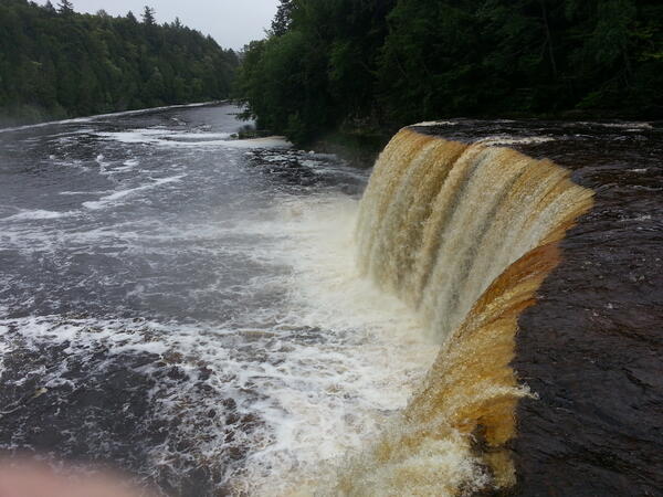
Tahquamenon River, MI Toxic Substances and areas of concern
Photo of Tahquamenon River, MI
Toxic Substances and Areas of Concer
Photo of Tahquamenon River, MI
Toxic Substances and Areas of Concer
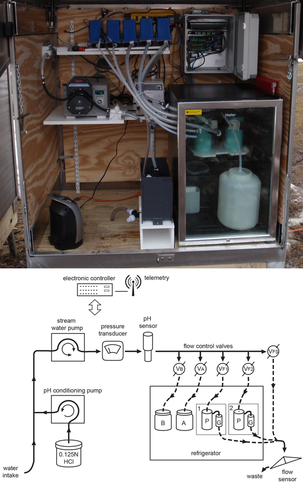
A custom automated pathogen sampler and schematic illustration.
A photograph of U.S. Geological Survey (USGS) custom automated pathogen sampler (top) and schematic illustrating the remote-unattended-automated pathogen sampler (bottom). Sample collection proceeds over the course of a runoff-event or low-flow period for up to a maximum of 5 days before a site visit by personnel is needed to collect the samples.
A photograph of U.S. Geological Survey (USGS) custom automated pathogen sampler (top) and schematic illustrating the remote-unattended-automated pathogen sampler (bottom). Sample collection proceeds over the course of a runoff-event or low-flow period for up to a maximum of 5 days before a site visit by personnel is needed to collect the samples.

View of the Great Lakes from ISS
Veiw of the Great Lakes from space on the ISS
Veiw of the Great Lakes from space on the ISS

Edge-of-field: runoff before and after conservation practice install
These photos, taken before and after a grassed-waterway conservation practice was installed, show a change in the water clarity of agricultural runoff at an edge-of-field surface monitoring site in Wisconsin.
These photos, taken before and after a grassed-waterway conservation practice was installed, show a change in the water clarity of agricultural runoff at an edge-of-field surface monitoring site in Wisconsin.

Edge-of-field: sites and installations
These photos show various edge-of-field monitoring surface and subsurface monitoring sites, installation efforts, and runoff events across the Great Lakes basin.
These photos show various edge-of-field monitoring surface and subsurface monitoring sites, installation efforts, and runoff events across the Great Lakes basin.
Videos
")
Monitoring Stormwater and Green Infrastructure (Gary City Hall, Ind.)
This time-lapse video shows the construction of the new Gary City Hall parking lot and rain garden in Gary, Indiana. The City of Gary is utilizing green infrastructure in their redevelopment projects in the hopes of reducing the amount stormwater runoff that enters their storm-sewer system and, eventually, Lake Michigan.
This time-lapse video shows the construction of the new Gary City Hall parking lot and rain garden in Gary, Indiana. The City of Gary is utilizing green infrastructure in their redevelopment projects in the hopes of reducing the amount stormwater runoff that enters their storm-sewer system and, eventually, Lake Michigan.
")
Edge-of-Field Monitoring Using Depth-Integrated Sample Arm (DISA)
During edge-of-field monitoring of an agricultural field runoff event, a depth-integrated sample arm (DISA) is used to take a water sample at the same time a traditional water sample is taken from an intake located at the bottom of the H-flume exit, where the water is assumed to be completely mixed.
During edge-of-field monitoring of an agricultural field runoff event, a depth-integrated sample arm (DISA) is used to take a water sample at the same time a traditional water sample is taken from an intake located at the bottom of the H-flume exit, where the water is assumed to be completely mixed.

Time-Lapse of Edge-of-Field Event Near Fort Wayne, IN
Time-lapse photo of a rainfall-induced runoff event at an edge-of-field surface site near Fort Wayne, Indiana, on May 10-11, 2016. Edge-of-field monitoring is used to assess the quantity and quality of agricultural runoff and evaluate the effectiveness of conservation practices that aim to reduce nutrient loss.
Time-lapse photo of a rainfall-induced runoff event at an edge-of-field surface site near Fort Wayne, Indiana, on May 10-11, 2016. Edge-of-field monitoring is used to assess the quantity and quality of agricultural runoff and evaluate the effectiveness of conservation practices that aim to reduce nutrient loss.