
Table showing different types of geochronology techniques, the ages over which those techniques are best applied, and the meaning of the ages determined by the techniques.
Mark E. Stelten, PhD
Research geologist with expertise in 40Ar/39Ar and 238U-230Th geochronology. Research focuses on reconstructing the eruptive history of volcanic systems and understanding the magma plumbing systems that feed volcanic eruptions.
I have been conducting research on magmatic systems since 2008 with an emphasis on geochronology and geochemistry. The primary tool of my research is geochronology, particularly 40Ar/39Ar geochronology to determine the eruption age of volcanic rocks and 238U-230Th-226Ra geochronology to determine when the minerals hosted within volcanic rocks crystallized. By integrating geochronology with the chemical and isotopic composition of volcanic rocks and their minerals, I seek to understand (1) the eruptive history of volcanic systems, (2) how magma is generated and stored prior to volcanic eruptions, and (3) the rates and durations of volcanic eruptions.
I have worked on a variety of volcanic and plutonic systems over the course of my career. Prior to working with the U.S. Geological Survey, I conducted research on the Tuolumne Intrusive Suite in Yosemite National Park, California, South Sister volcano in Oregon, and the Yellowstone Plateau Volcanic Field in Wyoming. I began working at the U.S. Geological Survey in 2015 as a postdoc. My postdoctoral work focused on using 40Ar/39Ar geochronology to reconstruct the eruptive history of the Harrat Rahat volcanic field, Kingdom of Saudi Arabia, for the purposes of volcanic hazard assessment. Currently, I am using 40Ar/39Ar geochronology in combination with a variety of other geochemical data sets to understand the recent eruptive history at Yellowstone caldera in Wyoming, Newberry volcano in Oregon, Moffett and Adagdak volcanoes in Alaska, and the San Francisco Volcanic Field in Arizona.
In addition to studying volcanic systems, I also collaborate with researchers in the Geology, Minerals, Energy, and Geophysics Science Center to study the tectonic and geomorphic evolution of the western U.S.
Science and Products

table of geochronology techniques
Table showing different types of geochronology techniques, the ages over which those techniques are best applied, and the meaning of the ages determined by the techniques.

Map of Yellowstone caldera showing the locations and ages of the Central Plateau Member rhyolites
linkMap of Yellowstone caldera showing the locations and ages of the most recent rhyolite eruptions at Yellowstone, the Central Plateau Member rhyolites. Unit boundaries are from Christiansen (2001).
Map of Yellowstone caldera showing the locations and ages of the Central Plateau Member rhyolites
linkMap of Yellowstone caldera showing the locations and ages of the most recent rhyolite eruptions at Yellowstone, the Central Plateau Member rhyolites. Unit boundaries are from Christiansen (2001).

Yellowstone rhyolite generation
Schematic cross section of the magmatic system underneath Yellowstone Caldera and illustrating the processes of rhyolite formation.
Schematic cross section of the magmatic system underneath Yellowstone Caldera and illustrating the processes of rhyolite formation.

Panoramic photo of the West Yellowstone rhyolite lava flow
Panoramic of the West Yellowstone rhyolite lava flow taken along Highway 20 (between the West entrance of Yellowstone National Park and Madison Junction). The flow is approximately 111,000 years old and has a volume of about 41 km3 (10 mi3).
Panoramic of the West Yellowstone rhyolite lava flow taken along Highway 20 (between the West entrance of Yellowstone National Park and Madison Junction). The flow is approximately 111,000 years old and has a volume of about 41 km3 (10 mi3).

View north along U.S. Route 20 from near Ashton, ID, at the margin of the Huckleberry Ridge Tuff in the distance
linkGoogle maps photo taken just north of Ashton, ID, along U.S. Route 20. The photo was taken looking north towards Island Park, ID. The forested ridge in the distance marks the margin of a caldera that formed 2.08 million years ago, when the Huckleberry Ridge Tuff erupted.
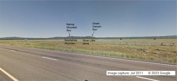
Looking west from the intersection of U.S. Route 20 and Old Hwy 47, in Idaho, at lava flows associated with the Henrys Fork caldera
linkGoogle Maps photo taken at the intersection of U.S. Route 20 and Old Hwy 47 in Idaho, looking west. The tops of Moonshine Mountain and Silver Lake dome, rhyolite lava flows located inside the caldera, are indicated with a dashed black line.
Science and Products
table of geochronology techniques
Table showing different types of geochronology techniques, the ages over which those techniques are best applied, and the meaning of the ages determined by the techniques.
Table showing different types of geochronology techniques, the ages over which those techniques are best applied, and the meaning of the ages determined by the techniques.
Map of Yellowstone caldera showing the locations and ages of the Central Plateau Member rhyolites
linkMap of Yellowstone caldera showing the locations and ages of the most recent rhyolite eruptions at Yellowstone, the Central Plateau Member rhyolites. Unit boundaries are from Christiansen (2001).
Map of Yellowstone caldera showing the locations and ages of the Central Plateau Member rhyolites
linkMap of Yellowstone caldera showing the locations and ages of the most recent rhyolite eruptions at Yellowstone, the Central Plateau Member rhyolites. Unit boundaries are from Christiansen (2001).
Yellowstone rhyolite generation
Schematic cross section of the magmatic system underneath Yellowstone Caldera and illustrating the processes of rhyolite formation.
Schematic cross section of the magmatic system underneath Yellowstone Caldera and illustrating the processes of rhyolite formation.
Panoramic photo of the West Yellowstone rhyolite lava flow
Panoramic of the West Yellowstone rhyolite lava flow taken along Highway 20 (between the West entrance of Yellowstone National Park and Madison Junction). The flow is approximately 111,000 years old and has a volume of about 41 km3 (10 mi3).
Panoramic of the West Yellowstone rhyolite lava flow taken along Highway 20 (between the West entrance of Yellowstone National Park and Madison Junction). The flow is approximately 111,000 years old and has a volume of about 41 km3 (10 mi3).
View north along U.S. Route 20 from near Ashton, ID, at the margin of the Huckleberry Ridge Tuff in the distance
linkGoogle maps photo taken just north of Ashton, ID, along U.S. Route 20. The photo was taken looking north towards Island Park, ID. The forested ridge in the distance marks the margin of a caldera that formed 2.08 million years ago, when the Huckleberry Ridge Tuff erupted.
Looking west from the intersection of U.S. Route 20 and Old Hwy 47, in Idaho, at lava flows associated with the Henrys Fork caldera
linkGoogle Maps photo taken at the intersection of U.S. Route 20 and Old Hwy 47 in Idaho, looking west. The tops of Moonshine Mountain and Silver Lake dome, rhyolite lava flows located inside the caldera, are indicated with a dashed black line.