
Volcano Science Center
Find U.S. Volcano
The Volcano Science Center is the primary center serving the mission of the USGS Volcano Hazards Program — to enhance public safety and minimize social and economic disruption from volcanic unrest and eruption. The center is home to the five US volcano observatories with offices in Anchorage, Alaska; Menlo Park and Mountain View, California; Vancouver, Washington; and Hilo, Hawaii.


News
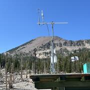
Mapping snow- and ice-free zones to monitor thermal activity in Yellowstone using high-resolution commercial satellite imagery
Mapping snow- and ice-free zones to monitor thermal activity in Yellowstone using high-resolution commercial satellite imagery
Volcano Watch — Pele, Lono, and Hiʻiaka remind us of Nature’s power
Volcano Watch — Pele, Lono, and Hiʻiaka remind us of Nature’s power
Hot Spring Cleaning!
Hot Spring Cleaning!
Publications
Spatial and temporal geochemical variations of lava flows and tephra deposits from the December 2020 to September 2024 eruptions of Kīlauea volcano Spatial and temporal geochemical variations of lava flows and tephra deposits from the December 2020 to September 2024 eruptions of Kīlauea volcano
Kīlauea volcano underwent dramatic morphological changes in 2018. That year recorded the end of the 35-year-long eruption of Puʻuʻōʻō (1983–2018) and 10-year-long (2008–2018) Halemaʻumaʻu lava lake and emplacement of the ~4-month-long lower East Rift Zone lava flows that coincided with ~500 m of summit caldera collapse. Starting on December 20, 2020, eruptions resumed at Kīlauea’s summit...
Small-volume tephra deposits of the May 1924 explosions from Halemaʻumaʻu, Kīlauea volcano, and their origin Small-volume tephra deposits of the May 1924 explosions from Halemaʻumaʻu, Kīlauea volcano, and their origin
More than 50 explosive eruptions occurred from Halemaʻumaʻu at Kīlauea volcano over 17 days from May 11 to 27, 1924. Ballistics weighing as much as 14,000 kg were ejected and most landed within 2 km of the vent. Fine ash made up a major component of the tephra and was dispersed tens of kilometers downwind. Draining of the Halemaʻumaʻu lava lake occurred in late February 1924, with the...
Forecasting volcanic activity in Germany—A multi-criteria approach Forecasting volcanic activity in Germany—A multi-criteria approach
Igneous activity, including shallow intrusions and volcanism, has the potential to disrupt underground critical infrastructure. Notably, future underground infrastructure projects like high-level radioactive waste repositories must be sited in areas of extremely low disruption probability by igneous activity. In Germany, according to the Repository Site Selection Act of 2017...
Science
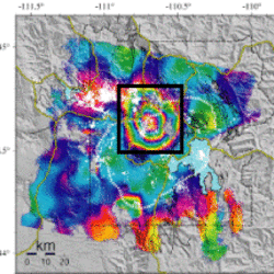
Uplift along the north rim of Yellowstone Caldera
An area on the north rim of Yellowstone caldera, to the south of Norris Geyser Basin, started to uplift slightly in July 2025. Similar deformation occurred in the same area during 1996-2004 and reveals characteristics of the subsurface.
USGS volcano-hydrothermal fluid chemistry data
The USGS has published chemistry data for volcanic and hydrothermal fluids sampled at sites around the United States.

How are lava flows mapped in Hawaii?
Lava flow mapping provides situational awareness of volcanic eruptive hazards in Hawaii. During eruptions, USGS Hawaiian Volcano Observatory (HVO) scientists employ a variety of techniques to collect and disseminate map data depicting key eruptive features, especially lava flows.