
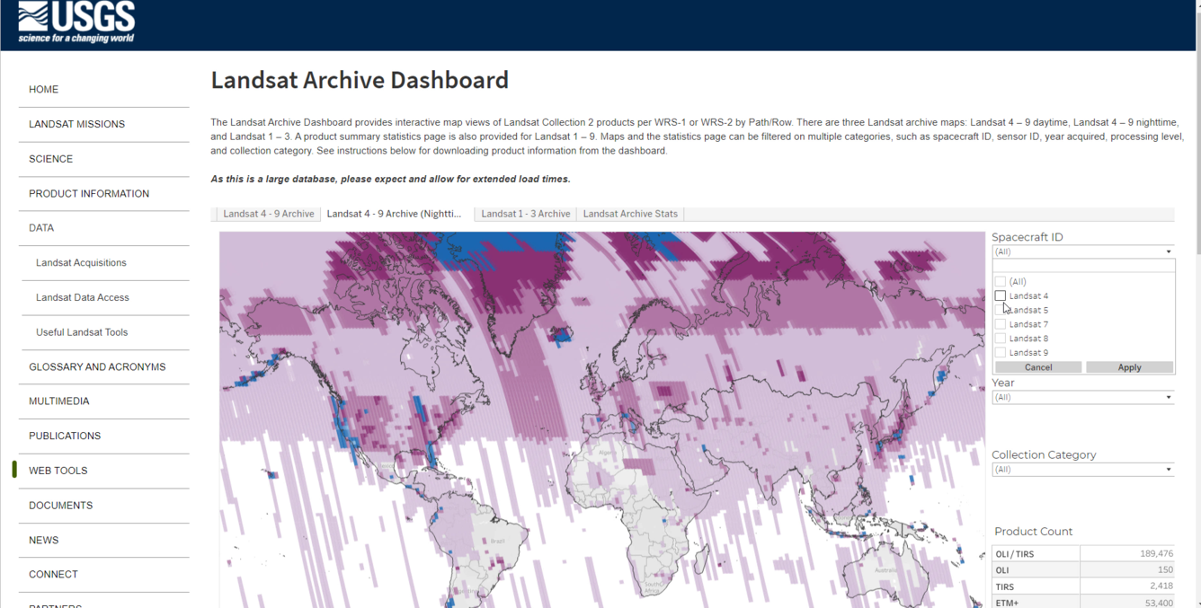
How to Use the Landsat Archive Dashboard
The Landsat Archive Dashboard allows you to explore and examine the vast USGS EROS archive of Landsat Collection 2 Level-1 and Level-2 products.
- The Landsat 4 - 9 archive map is based on the 2 (WRS-2) that contains 233 Paths.
- The Landsat 1 - 3 Archive map is based on WRS-1 and contains 251 Paths.
The colors on the maps show detail about the number of products per Path/Row. Hover details are shown for Path/Row reference and number of products per Path/Row. The data is filtered on Spacecraft ID, Sensor, Year Acquired, Collection Category, and Processing Level.
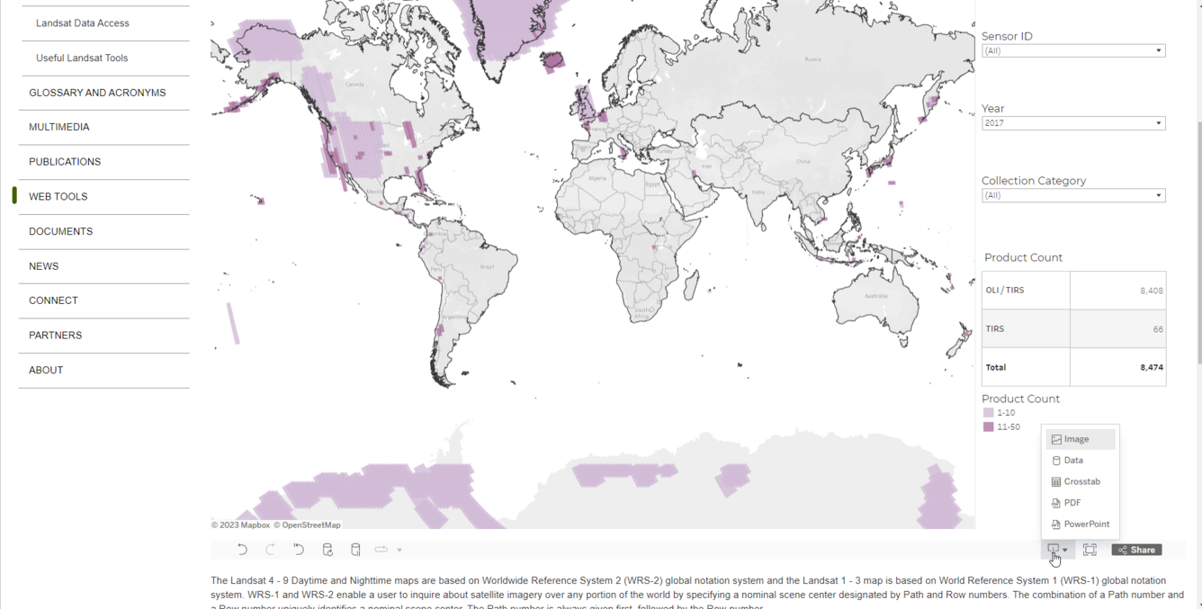
Downloading Scene Metadata from Landsat Archive Dashboard
When filtered to 10,000 scenes or less, users can select the download icon in the bottom right corner of the dashboard and select "Data" to download scene metadata. Users interested in larger metadata downloads should use the Landsat Bulk Metadata download tool.
Step 1
Use the filters on the right and the map tools to narrow down an area of interest with 10,000 products or less.
Step 2
After filtering, select the download icon in the bottom right corner. From the download options select "Data." If the "Data" option is grayed out, filter out more products. Use "Data" from the downloads options instead of "Crosstab" to obtain individual product information from the filtered results.
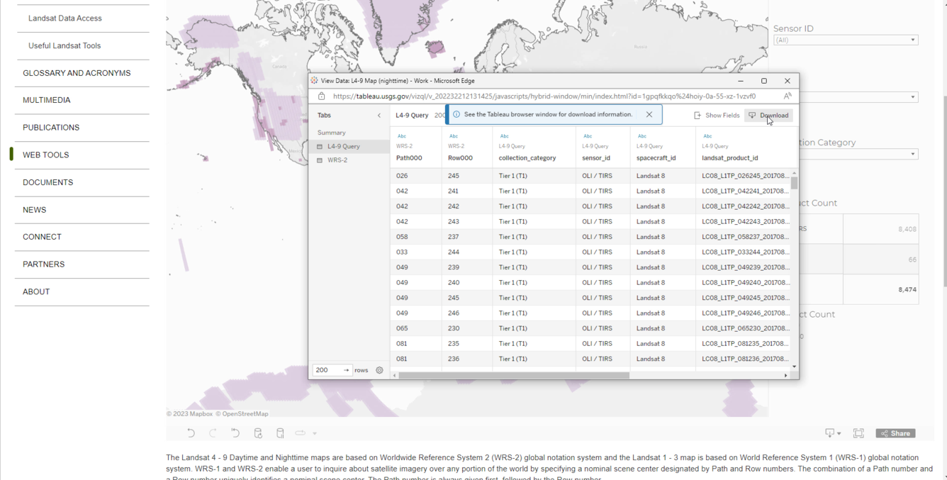
Step 3
From the left side of the popup box, select "L4-9 Query," which contains the filtered product information. Click the "Show Fields" button in the top right corner to add additional fields from the data source i.e. s3_location, date_acquired. The s3_location field provides the file path location to Landsat products stored in the commercial cloud. Select the "Download" button in the top right corner to download the filtered results from the map.
Product Information
For more information on the Landsat products used to create this dashboard, please see the following pages:
Level-1 Digital Object Identifiers (DOI)
- Landsat 8-9 OLI/TIRS Collection 2 Level 1 - doi.org/10.5066/P975CC9B
- Landsat 7 ETM+ Collection 2 Level 1 - doi.org/10.5066/P9TU80IG
- Landsat 4-5 TM Collection 2 Level 1 - doi.org/10.5066/P918ROHC
- Landsat 1-5 MSS Collection 2 Level 1 - doi.org/10.5066/P9AF14YV
Level-2 Digital Object Identifiers (DOI)
- Landsat 8-9 OLI/TIRS Collection 2 Level-2 - doi.org/10.5066/P9OGBGM6
- Landsat 7 ETM+ Collection 2 Level-2 - doi.org/10.5066/P9C7I13B
- Landsat 4-5 TM Collection 2 Level-2 - doi.org/10.5066/P9IAXOVV
Any use of trade, firm, or product names is for descriptive purposes only and does not imply endorsement by the U.S. Government.
Not for navigational use.