
Acoustic Backscatter Intensity
By Woods Hole Coastal and Marine Science Center
2012 (approx.)

Detailed Description
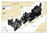
Acoustic backscatter intensity data are an indication of the relative hardness or softness of the sea floor, which is closely related to sediment texture and cohesion. The map shows acoustic backscatter intensity of the sea floor in the Buzzards Bay, Massachusetts. In general, higher values (light tones) represent rock, boulders, cobbles, gravel, shell reefs, and coarse sand. Lower values (dark tones) generally represent fine sand and muddy sediment. Within Buzzards Bay, high acoustic backscatter is most often associated with glacial deposits, such as moraines and meltwater fans. Low acoustic backscatter in the basins of Buzzards Bay are Holocene marine and estuarine muddy deposits.
Sources/Usage
Public Domain.