
AEM survey over Kīlauea summit

Detailed Description
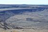
A telephoto view of the Airborne Electromagnetic and Magnetic (AEM) survey over Kaluapele (Kīlauea summit caldera) on July 28, 2022. The helicopter and hoop are visible in the center of the image, surveying over the down-dropped block within Kīlauea caldera. This project is funded by the Additional Supplemental Appropriations for Disaster Relief Act of 2019 (H.R. 2157), which supports investigations into the current state of Kīlauea volcano following the 2018 lower East Rift Zone eruption and summit collapse. Data gathered during the survey will allow USGS scientists to create an image of what is below the surface of Kīlauea volcano, including shallow magmatic structures, fault systems, and groundwater pathways. USGS photo by K. Mulliken.
Sources/Usage
Public Domain.