
Airplane for USGS MAP Study

Detailed Description
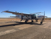
Airplane that will conduct low-level flights. Beneath the plane is a "bird" receiver (shown here in its stowed position under the aircraft) which will be towed behind the aircraft during the survey. Operated by Xcalibur Multiphysics under contract to the USGS. Photo courtesy Xcalibur Multiphysics.
Sources/Usage
Public Domain.