
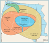
Ashfall for 4 major eruptions in the U.S.
By Volcano Hazards Program
2010 (approx.)

Detailed Description
Map showing the minimum area covered by volcanic ash from eruptions of Valles Caldera, Mount St. Helens, Yellowstone, and Long Valley Caldera.
Sources/Usage
Public Domain.