
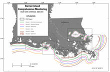
Data-coverage map for each BICM task
By St. Petersburg Coastal and Marine Science Center
2016 (approx.)

Detailed Description
Data-coverage map for each State of Louisiana Barrier Island Comprehensive Monitoring (BICM) task: barrier-shoreline post-storm assessment, historical shoreline changes, bathymetric and historical seafloor change, lidar surveys for the Louisiana coast, habitat mapping and change analysis, and characterization of coastal surface-sediment samples.
Sources/Usage
Public Domain.