
Digital Elevation Map of Mount St. Helens with annotation of pre-19...
By Volcano Hazards Program
2013 (approx.)

Detailed Description
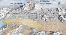
This shaded relief image was produced from LIDAR data. LIDAR is an acronym for Light Detection and Ranging, a modern remote sensing technique used to map topography very accurately—more so than is possible with older techniques. The crater is 1.2 miles (1.9 km) wide east-west. Elsewhere the scale varies owing to the oblique viewing angle. The landslide deposit includes the hummocks deposited to the northwest, and the location where the debris avalanche ruan-up a steep south-facing slope (bottom of image). The pumice plain is the location of a large fallout deposit from the Plinian phase of the eruption. Age of the domes in the center of the crater is indicated in the call-out text.
Sources/Usage
Public Domain.
Dzurisin et al. 2013 (in press)
Related

Geologic History Summary for Mount St. Helens
Mount St. Helens, located in Washington State, is the most active volcano in the Cascade Range, and it is the most likely of the contiguous U.S. volcanoes to erupt in the future.
Related
Geologic History Summary for Mount St. Helens
Mount St. Helens, located in Washington State, is the most active volcano in the Cascade Range, and it is the most likely of the contiguous U.S. volcanoes to erupt in the future.