
Map showing volcanoes that formed at the leading edge of the Yellowstone hotspot in the past several million years

Detailed Description
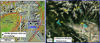
Map showing volcanoes that formed at the leading edge of the Yellowstone hotspot in the past several million years. (A) Map of northwest Wyoming, eastern Idaho, and southern Montana (modified from Brueseke et al., 2017, https://doi.org/10.1130/GES01553.1). Upper Wind River Basin (UWRB) is depicted by dashed blue rectangle. Black dots denote igneous rocks that are less than 10 million years old on the periphery of the Snake River Plain (dashed ovals where HS=Heise volcanic field, YS=Yellowstone Plateau volcanic field; numbers are ages in millions of years when these volcanic fields were active). Red lines denote the width of the ‘seismic parabola’ (an area of high seismicity) associated with the Yellowstone hotspot’s current location and the Yellowstone Crescent of High Terrain; JH=Jackson Hole, WRR=Wind River range, TR=Teton Range, CV=Centennial Valley. (B) Google Earth satellite image of UWRB study area depicting identified volcanoes and the extent of studied UWRB igneous rocks. P=Pilot Knob, LM=Lava Mountain, CM=Crescent Mountain, RT=Raggedtop Mountain, HB=Hey Bear volcano, SM=Spring Mountain.
Sources/Usage
Modified from Brueseke et al., 2017, https://doi.org/10.1130/GES01553.1, used with permission.