
Geologic mapping in remote interior Alaska

Detailed Description
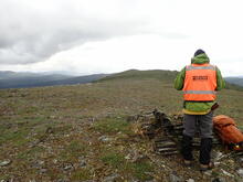
A USGS scientist is recording structural measurements collected from an outcrop of deformed and metamorphosed bedrock in the Yukon-Tanana upland of eastern interior Alaska. A team of two geologists were deployed by helicopter to conduct a geologic mapping and sampling traverse covering approximately 5 miles along the top of this ridge. Similar mapping traverses along other ridges and areas of outcrop in the surrounding region allow scientists to construct new or update older bedrock geologic maps. These maps and associated analytical data improve mineral resource assessments and provide information that supports land use planning and other stakeholder needs.
Sources/Usage
Public Domain.
Jamey Jones, U.S. Geological Survey