
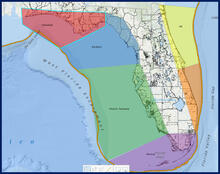
Graphic location map shows the six regions of FCMaP

Detailed Description
Florida Coastal Mapping Program (FCMaP) location map shows the six regions for gap analysis and prioritization; the Panhandle, Big Bend, West Florida Peninsula, the Florida Keys, the southeast coast, and the northeast coast.
Sources/Usage
Public Domain.
Image courtesy of FWRI
Related

The Florida Coastal Mapping Program
The Florida Coastal Mapping Program (FCMaP) is an initiative between Federal and Florida State agencies and institutions to coordinate and facilitate the collection and accessibility of Florida coastal seafloor data in order to fill priority areas and gaps. FCMaP is affiliated with the Florida Institute of Oceanography (FIO) whose activities are guided by the FCMaP Science and Technical Advisory...
Related
The Florida Coastal Mapping Program
The Florida Coastal Mapping Program (FCMaP) is an initiative between Federal and Florida State agencies and institutions to coordinate and facilitate the collection and accessibility of Florida coastal seafloor data in order to fill priority areas and gaps. FCMaP is affiliated with the Florida Institute of Oceanography (FIO) whose activities are guided by the FCMaP Science and Technical Advisory...