
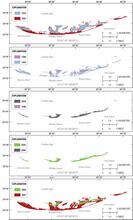
Historical shoreline positions for the Isle Dernieres

Detailed Description
Historical shoreline positions for the Isle Dernieres from 1887 to 2005 with change maps for time periods: 1887–1934, 1934–1996, 1996–2004, and 2004–2005 (modified from BICM Volume 2).
Sources/Usage
Public Domain.